Monday, August 31, 2020

Cumulative COVID-19 Cases by Municipal Area in South of Fraser/Fraser Valley

The BC CDC has recently shared the number of COVID-19 cases by Local Health Area. They included a map which has a colour-coded representation of the cases per 100,000. To help quantify the data further, I thought I would create a chart.

This chart is based on the following table which includes the cumulative number of COVID-19 cases from January until the end of July from the BC CDC, and the 2019 municipal population estimates.

Municipal Area Population Cumulative Cases Rate per 100,000
Chilliwack 94,534 34 36
Delta 109,490 62 57
Ridge Meadows 110,950 96 87
Langley 158,642 138 87
Surrey/White Rock 605,553 585 97
Abbotsford 158,457 454 287
Mission 43,202 158 366

As a note, there was a serious COVID-19 outbreak in the Mission Institution medium security federal prison.

Thursday, August 27, 2020

Aerial photo shows western portion of Downtown Langley City in 1985

I am interested in the history of Langley Prairie, now Langley City. It is important to know about the anthropology for where we live, including how we move around. Langley City exists today because it was a path between what we now called the Salmon River and Nicomekl River. Later, it became an important commercial hub as it was at the intersection of Yale Road to the interior, and Glover Road to Fort Langley. Yale Road became the first alignment of the Trans-Canada Highway.

You can learn a lot about a community by observing its transportation networks. Last year, I wrote a post called, “The search for the meaning of “crescent” found in aerial photos of mid-20th century Langley City.” The post contains old aerial photos of Langley Prairie from that time period.

Downtown Langley City in 1985, focused around 203rd Street. Select image to enlarge.

Recently, I received a Facebook message directing me to Waite Air Photos which has aerial photos of Langley dating back to 1985. These pictures must be purchased for use.

One of the pictures that stood out to me shows the western end of Downtown Langley in 1985.

It is interesting to see the significant changes to the road network over the years.

For example, 203rd Street did not connect between 56th Avenue and Fraser Highway. It was the site of a Safeway. Today, I wonder if extending 203rd Street was a good idea; the extension has made a challenging intersection.

You can also see how 56th Avenue between 7-11 and the former Langley Hotel was a major route. The bottom of the photo (where there is a parking lot) was the old Interurban rail alignment which provided passenger and freight service from Vancouver to Chilliwack until the mid-20th century.

201A Street was also a major route. You can see some of the early apartments that were built in our community. 201A Street made a 90 degree turn at what is now Linwood Park, to connect to 200th Street back then.

If you look at the top of the photo, there is no Willowbrook Mall, and the Langley Bypass actually bypassed Langley City.

There are many other observations that can be made by looking at Langley City 35 years ago.

Wednesday, August 26, 2020

Reducing on-site parking to fight climate change and create a more affordable Langley City

Langley City staff, consultants, and council are in the process of updating our Official Community Plan. This foundational plan will help guide development in our community, if adopted, for years to come. There has been significant consultation to date about the proposed updated OCP. Earlier this summer, I posted about the key themes that emerged from the visioning workshops, open houses, pop-up events, and online survey.

Creating more affordable housing options and fighting climate change were two of the five key themes. The new OCP is being planned for a community with high-quality transit in mind such as RapidBus and SkyTrain. One of the ways to create affordable housing options and fight climate change is to reduce on-site parking requirements.

I posted in 2019 that a recent Metro Vancouver Regional District study found that there is an oversupply of on-site residential apartment parking in our region, including in Langley City. The cost to create a apartment parking spot is around $55,000 each.

When it comes to commercial property, surface parking lots create impervious surfaces which have a negative impact on environmental and human health. For example, unfiltered stormwater which contains pollutants ends up in our ecosystem when it rains. Impervious surfaces such as surface parking lots also contribute to the heat island effect.

Surface parking lots also cause buildings to be spread out which reduces walkability.

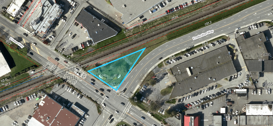
One of the interesting case studies in Langley City is Valley Centre Mall. This mall is located at 201A Street and Fraser Highway. It has seen two infill projects over the years: the Starbucks and Scotiabank buildings which front Fraser Highway. Because of these infill projects, the property owner is required to maintain a parking lots off Industrial Avenue to meet the current City’s minimum on-site parking requirements.

The following picture shows what that parking lots normally looks like.

Parking lot for Valley Centre Mall at 20229 Industrial Avenue. Select image to enlarge.

While Valley Centre Mall has a busy main parking lot, there is normally parking available.

Langley Mall is located near City Hall. Its parking lot was only ever full when the Cruise-In event happened in our community.

Recently, Langley City council has supported staff recommendations to reduced on-site parking requirements for projects near future SkyTrain stations.

While parking is tight in some single-family and townhouse-only areas, there is opportunity to reduce on-site parking requirements for apartment and commercial areas.

This will help create a more affordable and walkable community, and will help fight climate change.

Tuesday, August 25, 2020

Unofficially naming the parklet at the corner of Production Way and Fraser Highway. People’s suggestions revealed.

Over the last few weeks, I asked people to submit their naming suggestions for the unnamed parklet at the corner of Fraser Highway and Production Way. This survey was not official in any way.

Location of unnamed parklet - 5999 Production Way. Select image to enlarge.

With so many serious things going on right now, sometimes it is good to have a little break. There were 47 suggestions received. There were of course some silly suggestions such as Parky McParkface and Pachal Park.

After some curation of the names received, here is the list of suggestions with context as required:

  • By the Rails Park
  • FP Park - Fraser Production.
  • Fraser Way Park
  • Heroes Park
  • Hunter Vogel Park - First Mayor of Langley City. Appointed between March 15, 1955 and May 29, 1955.
  • Industrial Park
  • Jack Arnold Park - Long serving Langley City Councillor from 1990 until 2018.
  • Joe Chesney Park - Started BC's first full-time country music radio station, broadcasting from Langley from the early 1960s to mid 1980s.
  • Lucky Triangle Park
  • Pleasant Park
  • Production Park
  • Railway Park
  • SkyTrain View Park
  • tawâw Park – Cree word meaning “come in, you're welcome; there's room.”
  • Triangle Park
  • Willowbrook Park

In the next little bit, I’ll put together a survey for people to vote for the unofficial name of the park based on these suggestions.