Thursday, May 31, 2018

204th and 54th crosswalk enhancements make walking safer

If you’ve travelled along 204th Street between 53rd Avenue and Downtown Langley recently, you’ll have likely noticed some changes to the crosswalk at the 54th Avenue intersection.
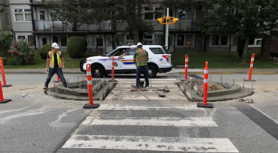
Construction crews working on enhancing the crosswalk at 204th Street and 54th Avenue. Select image to enlarge.

This crossing is well used by people in the area including many seniors. Because of the large width of the road, people driving vehicles regularly fail to stop for people that want to use the crosswalk. The width of 204th Street in that area also encourages people to speed along the corridor. I use that crosswalk regularly, and have lost track of the number of near-misses and failed stops that I have experienced from people who drive through that intersection.

One of the recent changes to that intersection is the installation of a pedestrian-controlled flashing crosswalk. The crosswalk also includes enhanced lighting which will improve crosswalk visibility. Given the amount of days with grey skies and/or rain in Langley City, this is a major safety improvement.

Slowing down traffic is key to creating safer streets. People walking have an 80% risk of dying when hit by a person driving who is going 50km/h or higher, but only a 10% risk of dying when hit at 30km/h or less.

Enhanced crosswalk at 204th Street and 54th Avenue, looking north. Select image to enlarge.

Enhanced crosswalk at 204th Street and 54th Avenue at street level. Select image to enlarge.

Enhanced crosswalk at 204th Street and 54th Avenue, looking south. Select image to enlarge.

The pedestrian island which is featured in the preceding pictures serves three purposes. It enhances the visibility of people crossing, it reduces the amount of time a person is exposed directly to traffic, and it slows people driving down. All of these create a safer and more inviting walking experience.

One of Langley City council’s strategic priorities is to build a “multi-modal transportation network within the community and to encourage greater pedestrian and cyclist use.” Improving safety is key to encouraging more walking and cycling.

The crossing at 50A Avenue at 208th Street is getting a similar safety enhancement. I look forward to seeing safer crosswalks being rolled out throughout Langley City.

Wednesday, May 30, 2018

Continuing the Positive Momentum - An Election Announcement

Over the past few years, Langley City council has made progress investing in our neighbourhoods, our parks, and our Downtown. When I ran for council, I promised to take a fresh approach to addressing complex issues around safety and homelessness.

While progress has been made, there is still much more work to be done. That is why I have the following announcement to make.

Tuesday, May 29, 2018

It's Bike to Work Week in BC. Should it be Bike to Shops, Schools, and Parks Week instead?

This week is Bike to Work Week in BC, an opportunity to raise awareness about cycling as a way of commuting to work. Bike to Work Week started in Victoria back in 1995 with approximately 500 participants. Last year, 44,523 people in 56 communities around the province took part in Bike to Work Week events.

Langley is one of the communities that is officially part of this years Bike to Work Week. More information about events and prizes can be found at the Go By Bike BC website.

Yesterday, I had an opportunity to chat with Michelle Eliot and Tom Skinner from HUB Cycling about cycling in our province on BC Today. I was part of the second half of the show.

I started by pointing out that there is about 8% of the population that will ride their bike no matter what. These are the people that you see in shoulder bike lanes along 200 Street. There is around one-third of the population that will never ride a bike. This leaves around 60% of the population that wants to ride a bike if safe infrastructure is built such as buffered and protected bike lanes.

A person riding their bike along 203 Street in Langley City in a protected bike lane. Select image to enlarge.

I noted that communities throughout the province, from Langley City to Kelowna, are investing in cycling infrastructure that supports the 60% of people that are interesting in cycling as long as safe infrastructure is provided. This has resulted in the number of people riding bikes rapidly increasing.

While encouraging people to bike to work is important, only about one-third of all trips taken are for travelling between home and work in our region. Local governments should focus on providing safe cycling infrastructure for the majority of trips that get people to places where they shop, play, and socialize. In communities like Langley City which is 10 square kilometres, this is a real opportunity, maybe even more so than biking to work.

Monday, May 28, 2018

Light rail to cut Surrey B-Line travel time during peak period almost in half on opening day

TransLink and Surrey are building light rail along 104 Avenue and King George Boulevard between Newton and Guildford Town Centres. The total travel time from one end of the line to the other will be 27 minutes on light rail. Much has been said about this 27 minutes not being significantly different than the average 29 minutes it currently takes to ride the 96 B-Line between Newton and Guildford today. A key word is average.

Rendering of light rail system and Surrey's public realm. Select image to enlarge.

The light rail project team recently released a comprehensive environmental and socio-economic review of stage 1 of South of Fraser Light Rail. One of the sections of this review is on travel times and traffic. As noted in the review, it takes around “29 minutes on the 96 B-Line [between Newton and Guildford]. During periods of congestion, B-Line travel times can take longer than 50 minutes.” On day one of light rail’s operation, during peak periods, it will cut travel times by 23 minutes for transit riders.

If light rail wasn’t built, average B-Line travel times would continue to get worse. Travel times on the B-Line end-to-end would increase to 40 minutes by 2030, with travel times during peak travel periods being much worse.

End-to-end travel time will always be 27 minutes for light rail between Newton and Guildford Town Centres. This will not change based on the time of day, or years into the future. In 2045, at the busiest time of the day, it will still only take 27 minutes to get between Newton and Guildford on light rail.

When it comes to cars, it currently takes 20 minutes to get between Newton and Guildford along King George Boulevard and 104 Avenue. This is expected to increase to 32 minutes by 2030. Light rail will be a faster option than driving.

As Surrey and the South of Fraser continue to grow, transit service that runs in its own dedicated right-of-way will be required to give people a way out of congestion. It is because light rail will be running in its own right-of-way that its travel time will remain so consistent.

Stage one of light rail will remove around 1,600 vehicles per day of the road during the peak morning travel period by 2045. This is equal to around two lanes of traffic. Stage 1 will increase the number of people in Surrey who are within a 5-minute walk of rapid transit from around 1% to around 7%.

More information on travel times and traffic is provided in section 7.2 of the review.

Thursday, May 24, 2018

Game-changers that will deliver better health services in Langley

Accessing physical and mental health services can be a challenge in Langley and throughout the province. If you have a family doctor, your barriers to accessing health services are lower, but there is still a patchwork of seemingly uncoordinated services that must be navigated. For people without a family doctor, accessing these health services can almost feel impossible.

In late April, I attended a workshop hosted by the Langley Division of Family Practice called, “Team Langley goes to the Big Leagues — Primary Care Network Strategy Meeting.” The workshop was attended by people who work in health services and local government. The goal of the workshop was to create a vision of transforming the way that health care is delivered in Langley, so that everyone can have access to the right health services, when they need it, in our community.

At the beginning of the workshop, participants visualized how many health providers are required to deliver care for people with different needs. 10 health care providers are required to service the health needs of a senior in our community as an example.

People at the workshop identified the following as critical barriers for patients, providers, and the community that must be overcome to deliver better health services in Langley.

Barriers that limit access to health services in Langley. Select graphic to enlarge.

What really stood out was that limited access to home-based health services, mental health services, and addiction treatment services was a significant barriers to overcome. Another barrier was poor communication between providers for existing services. I remember one provider talking about the challenging paperwork required for something that should have been a simple request.

Most of the evening was spent visioning “game changing” ways that would deliver health services more effectively in our community. The following infographic shows the results of that exercise.

Game-changing ideas that will deliver better health services, and more positive health outcomes, for people in Langley. Select graphic to enlarge.

The big ideas were: providing a health care concierge that can help people navigate the health system, creating a better triage system, developing centralized and patient-led care plans, increasing access to mental health services, and creating neighbourhood-level health clinics where all primary health services could be accessed.

It was certainly an eye-opening night for me. It seemed to me that increasing access and improving coordination of health services will deliver the best outcome for people in Langley.

The full visual report is available for download. As a note, a provider is someone that delivers health services such as a physician.

Wednesday, May 23, 2018

Public supports TransLink’s transportation vision priorities

Back in 2014, the region’s mayors agreed on a 10-year vision for transportation focused on expanding high-quality public transit, enhancing walking and cycling infrastructure, and maintaining our regional road network.

Currently, phase 1 of the vision is funded and is being implemented. TransLink has setup an interactive map where you can view the status of all projects and expanded services that have been built, implemented, or are underway.

At the end of March, an agreement was reached to fund phase 2 of the vision. The two big items in phase two are extending the Millennium Line to Arbutus at Broadway in Vancouver, and building light rail in Surrey.

As part of the process, TransLink conducted a series of public consultations both online and in-person during the first half of this month. Around 2,700 people completed an online survey, and around 900 people participated in-person.

TransLink also commissioned a scientific survey of 2,000 Metro Vancouver residents. These residents were asked how important they felt the major components of phase 2 of the vision were for the region. The follow chart shows the summary of what people who participated in the survey thought.

Reponses to question: How important do you feel each of these planned transportation improvements is for the Metro Vancouver region? Select chart to enlarge.

The bus system is the backbone of the transit network in our region; the majority of transit trips are by bus. It was interesting to see that people placed a higher importance on expanding current service on the bus network and the SkyTrain network, over building new rail lines. In all cases, no more than 25% of participants thought that the phase two projects where not important.

When asked about the fairness of how phase two will be paid for, the majority of survey participant thought that the proposed funding sources were reasonably fair. The exception was property tax where 53% of people thought it was unfair.

Responses to questions Do you feel that these are fair or unfair ways of paying for the region’s portion of these transportation improvements? Select chart to enlarge.

There seems to be strong support for having developers pay for expanding transit service. This makes sense as growth should pay for growth. We currently have developers pay for expanding municipality infrastructure. As one of the participants noted, “Development [levies] are the best bet because of the value added to the properties near to the SkyTrain they should pay as they will see the higher increase in value.”

With phase one and phase two moving forward, all that remains is getting funding sorted out to pay for the final phase of the vision which includes building light rail to Downtown Langley. I am hopeful that this funding will get secured before the next federal election.

Tuesday, May 22, 2018

Building sidewalks, enhancing crosswalks supports our most vulnerable residents. Creating a better community for all.

When you create a community that supports its most vulnerable residents, you create a community that is better for everyone. Vulnerable residents can include young children, seniors, people with mental and/or physical disabilities, and people with lower incomes.

While education, health, and social support systems play critical roles in building strong communities, so does the built form of a community. How we design our buildings and neighbourhoods, how we place buildings in relationship to other buildings and our streets, and how we design our streets are also critical elements to creating communities that either support or detract from creating an inclusive community.

If you have lived in Langley City over the last decade, you will have noticed that there has been a renewed focus on investing in people-powered transportation infrastructure. Whether it is building sidewalks, enhancing crosswalks, or building safer cycling lanes, these investments support some of the most vulnerable residents in our community.

If you are a parent (or imaging being a parent), would you feel safe letting your child ride a bike on 208 Street in the shoulder bike lane? Would you feel more comfortable with them riding down 203 Street? If you had a scooter or other mobility-assistance device which corridor would you feel safer on?

To the point that when we build communities for the most vulnerable, we build better communities for all, more people in general are now using active forms of transportation along corridors like 203 Street than ever before. This promotes better health outcomes, builds a strong sense of community as people start seeing their neighbours, and gets more eyes and ears on the street which reduces crime.

Much of Langley City was built-out during an era when planners actively discouraged walking. As such, many parts of our industrial area, commercial areas outside of Downtown, and single-family housing areas lack the most basic form of infrastructure: the sidewalk.

I was reminded of how important sidewalks were this weekend as I watched a senior negotiating 62 Avenue on a scooter. The north side of 62 Avenue is in the Township while the south side is in the City.

A senior riding their scooter along 62 Avenue. Select image to enlarge.

The same seniors trying to cross 62 Avenue to get onto 203 Street.

Langley City council is investing in walking infrastructure. As I posted about previously, we are investing more than $1 million to support walking in this year alone. I was reminded this weekend that Langley City must not slowdown investing in transportation infrastructure that supports our most vulnerable residents. This situation of a senior navigating 62 Avenue needs to be a thing of the past in our community.

Thursday, May 17, 2018

Rental zoning will give municipalities new tool to support affordable housing

Yesterday, I posted about the state of rental housing in the South of Fraser based on information compiled by the BC Non-Profit Housing Association. The short of it is that market rental housing is becoming less affordable for people in our region. In Langley City, close to half of renter households spend more that 30% of their income on housing. Spending more than 30% of a household’s income on housing costs is considered unaffordable.

Transportation costs are significant for most renter households. The Metro Vancouver Regional District has done research around how to increase affordability for households that make a moderate income. Langley City’s average household income is around $50,000 per year. This is considered a moderate income.

Pinetree Way in Coquitlam is near high-quality public transit

Metro Vancouver’s solution is to build rental housing near high-quality public transit. One of the challenges with this today is that land near high-quality transit normally goes for a premium. One of the ways around this is to zone areas near high-quality transit for rental housing. This would dampen increasing land costs, as it would reduce speculative practices. Rental zoning would encourage people to create rental buildings for the long-term. This will result in more rental units, stabilizing rents throughout our region.

Currently, local governments don’t have the power to create rental zones, but this is about to change. The provincial government has a bill that is currently working its way through the legislature that would allow municipalities to create rental zones.

In Langley City and Surrey, rental zoning could be applied along sections of Fraser Highway, 104 Avenue, and King George Boulevard near transit stops. It could also be applied along B-Line routes. One of the good things about the proposed new rental zoning is that local governments don’t have to take an all-or-nothing approach to creating rental housing. The proposed zone would allow a municipality to make anywhere from 1% to 100% of building housing units rental within the zone. This would work well for mixed-use buildings.

While the provincial and federal governments hold most of the power to create affordable housing, the proposed new rental zoning will give local governments the ability to encourage affordable rental units for moderate income households in our region.

Wednesday, May 16, 2018

New index shows state of housing costs for renters in the South of Fraser

Ensuring that everyone can afford a place to live is one of the biggest challenges that our region has ever faced. Whether looking to own a home, rent at market rates, or get into some form of subsidized housing, most people are feeling the pressure.

The Canadian Rental Housing Index is put together by the BC Non-Profit Housing Association. It looks at rent affordability throughout Canada. The index was recently updated with the latest census data, and includes information at the municipal, regional, provincial, and federal levels. What does the index say about South of Fraser communities?

Langley City has some of the lowest household incomes in Metro Vancouver. The following chart shows the average and median gross incomes for renter households in 2016.

Average & Median Incomes in 2016: The average and median gross incomes of renter households. Select chart to enlarge.

The next chart shows the average monthly rent and utility costs in 2016.

Average Monthly Rent and Utilities in 2016: Includes heat, hot water, and electricity. Select chart to enlarge.

Langley City had some of the lowest housing costs in the South of Fraser, but because we also have the lowest household income levels, close to half of Langley City renter households are spending more than 30% of their income on housing. This means that these households are overspending on housing. Between 2016 and this year, the cost of housing has increased, so I would expect that the number of renter households that are overspending on housing costs is now larger.

Overspending in 2016: Households spending more than 30% of their before-tax income on rent and utilities are generally considered to be living in unaffordable situations. Select chart to enlarge.

Transportation is a critical component when it comes to affordability. In communities where driving is the only option, transportation costs can equal a third of housing costs. While in community where walking, cycling, and public transit are viable options, transportation costs can equal about a quarter of housing costs.

Transportation costs are not presented in this index. In the future, it would be good to see transportation costs also included.

The provincial government has recently put measures in place to address creating more affordable transportation and housing options. It will be interesting to see what impacts these policies will have over the next several years.

Tuesday, May 15, 2018

May 14 Council Meeting Notes: Increasing budget for Downtown Langley Business Improvement Area. New Employer Health Tax will rise property tax 1%.

As last night’s Langley City council meeting was only one week from the last meeting, it was brief.

The meeting opened with awarding Emily Condon, a student at Alice Brown Elementary, the winner of the Local Government Awareness Day poster contest. She drew the winner poster encouraging people to leave their phone alone when they are driving. Her and other student’s posters can be seen at Timms Community Centre.

Emily Condon receiving an award from the mayor. Select image to enlarge.

The Downtown Langley Business Association represents merchants in the business improvement area (BIA) as shown on the following map.

Downtown Langley Business Improvement Area highlighted in grey. Select map to enlarge.

One of the special features of a BIA is that property owners can choose to tax themselves over-and-above normal property tax to pay for additional services which are delivered through a business association. The City must enable this additional property taxation through a bylaw. The currently bylaw for the Downtown Langley BIA is expiring in 2019.

The Downtown Langley Business Association executive was present last night as Langley City Council considered giving first, second, and third reading to a new enablement bylaw for the period 2020 through 2029. The bylaw will enable a 7% budget increase per year for the business association, funded by an additional property tax applied only within the BIA. Their maximum budget will be $497,976 in 2020, rising to $915,508 in 2029.

Besides supporting merchants in our Downtown, the association partners with the City to deliver events that benefit all local residents. These events include Arts Alive, Fork ‘N’ Finger, and the McBurney Plaza Summer Series.

Council gave three readings to the BIA bylaw.

The provincial government is ending MSP premiums, replacing the lost revenue with a new Employer Health Tax. As local governments are employers, we will be subject to this new tax. For Langley City, this means that our property tax will have to increase by 1% or $291,000 in 2019 to cover this new Employer Health Tax. This will leave less funding available to fund critical local infrastructure and services.

This is a classic example of provincial government downloading. Langley City council passed a motion calling for the BC government to exempt local governments, regional districts and school boards from the Employer Health Tax to lessen the financial burden on local taxpayers. Council also asked that a letter be written to other municipalities encouraging them to also write letters to the province regarding the impact of the tax.

Langley City council gave final reading to the updated Parks & Public Facilities Regulation Bylaw, and associated updated Municipal Ticket Information System Bylaw. These updates include new restrictions on camping in our community. I posted about these changes in more detail last week.

Council also gave final reading to discharge the land use contract for 5139 206 Street to facilitate a secondary suite.

5454, 5464, 5474, 5484, 5490 Brydon Crescent are subject to rezoning. Select map to enlarge.

In order to allow a public hearing, council gave first and second reading to a zoning amendment to accommodate a 30 unit, 3-story townhouse project along Brydon Crescent as shown.

Monday, May 14, 2018

Maps and list of most Langley City infrastructure projects in progress

Last week, I posted about infrastructure projects that are under construction, will begin construction, or are in the design phase this year. In the post, there was a picture of the project map from a poster that was at the Douglas Neighbourhood Meeting.

Langley City has now posted higher-resolution maps that show many of the projects in our community that are in progress. These maps don’t contain city-wide projects such as replacing all streetlights will LED streetlights.

Alice Brown and Uplands Neighbourhood Projects. Select map to download

Simonds and Blacklock Neighbourhood Projects. Select map to download.

Nicomekl and Douglas Neighbourhood Projects. Select map to download.

Here is the complete list of projects on the maps:

  • Watermain Replacement 197A St, South of 46 Avenue
  • Hunter Park Renovation
  • Penzer Park, New Parking Lot
  • Penzer Park, New Washroom
  • New 46A Ave Sidewalk
  • Grade Crescent Corridor Planning
  • H.D. Stafford Traffic Calming
  • 48 Avenue Sanitary Sewer Rehabilitation
  • Reservoir SCADA System Upgrade
  • Muckle Creek Culvert Replacement at 48 Avenue and at 50 Avenue
  • New Traffic Signal at 50 Avenue and 200 Street
  • Booster Pump Station Removal at Grade Crescent at 200 Street
  • Nicomekl Floodplain Pedestrian Bridge Replacement near 201A Street, and near 203 Street
  • City Park, Spray Park and Playground Upgrades
  • City Park, New Walking Path, Passive Play Area, and Off-Leash Dog Area
  • City Park, Retaining Wall Replacement
  • City Park, South Field Renovation
  • Enhanced Crosswalk at 50A Avenue at 208 Street
  • Nicholas Park, Spray Park Upgrade
  • Brydon Park, Master Plan Design
  • Brydon Park, Playground/Sport Court Renovation
  • Traffic Calming at 198 Street at 53 Avenue
  • 56 Avenue Pavement Replacement between 198 Street and 200 Street
  • Watermain Upgrade along Fraser Highway near Surrey Border
  • Storm Sewer Relining along Fraser Highway near Railway Tracks
  • Michaud Greenway Concept Design
  • New Michaud Community Garden
  • Traffic Study for 62 Avenue
  • New Traffic Signal at 203 Street at Industrial Avenue
  • Duncan Way Industrial Area Sidewalks and Multi-Use Path Project
  • Glover Road Traffic Signal Rebuilds at 56 Avenue, Eastleigh Crescent, and Duncan Way
  • 56 Avenue Project between Glover Road and Langley Bypass
  • Logan Creek Culvert Replacement
  • Rotary Centennial Park Concept Design
  • Fraser Highway One-Way Concept Design
  • Douglas Park, Lighting Replacement
  • Douglas Park, Playground Replacement
  • Douglas Crescent Road and Utilities Project between 206 Street and 208 Street
  • Enhanced Crosswalk at 54 Avenue and 204 Street
  • Traffic Signal Rebuild at 51B/53A/53 Avenue

There are plenty of projects on-the-go that will ensure that our City can maintain and enhance the services required to provide a good quality of life for people who live in our community.

Thursday, May 10, 2018

May 7, 2018 Council Meeting Notes: Financial audit gives city clean bill of health, and development projects continue

On Monday night, Langley City’s council met for a public hearing and a regular council meeting. I’ve posted about some of the major items covered at these meetings including pending changes to our Parks & Public Facilities Regulation Bylaw, and infrastructure investments. Today, I will cover the remaining items from Monday night.

The first item covered at the public hearing was for a proposed 3-storey, 23 unit townhouse project at 20689 and 20699 Eastleigh Crescent.

Rendering of proposed townhouse project along Eastleigh Crescent. Select image to enlarge.

The proposed development has both double-wide and tandem parking garages. One person spoke to the development proposal. This person was concerned about tandem parking; that people would choose to park their second vehicle on the street. The person also questioned how people would use the roof-top patios which are proposed for the development.

As our community continues to grow, ensuring the fair use of on-street parking will be an increasing challenge. I believe that a parking permitting system to ensure that all residents in an area have equal opportunity for on-street parking access should be considered in the near future.

Council gave third reading for rezoning the property to accommodate this project.

Council also gave third reading to remove the land-use contract for 5139 206 Street to permit a secondary suite. Land-use contracts stopped being issued in BC over 30 years ago.

Council gave final reading, and issued a development permit, to accommodate a 3-storey, 39-unit townhouse project at the end of 199A Street. You can read more about this project in a previous post.

The City’s finances need to be audited every year by an independent third party. The auditor presented their findings at the council meeting, giving the City a clean bill of health. You can download the consolidated financial statements for more information.

On the topic of finances, council must pass a bylaw that aligns the budget and the consolidated financial statements. Council gave third reading to this bylaw for the 2017 budget year. Council also gave final reading to the tax rate bylaw for 2018.

As a housekeeping item, Council gave three readings to a bylaw to update council procedures. The updated bylaw includes new provision on how council members can behaviour at meetings, formal processes, and what time a council meeting ends at.

Finally, council gave three readings to remove a section of road dedication in the lane off 204 Street and Park Avenue as shown.

Site plan including proposed road dedication removal near Park Avenue. Select image to enlarge.

Wednesday, May 9, 2018

Infrastructure projects on the go in Langley City. Investing in walking, lighting, and parks.

With the summer construction season here, Langley City will be full of activity as investment in infrastructure continues at a record pace. Improving walking infrastructure such as sidewalks is something that I strongly believe in, and it is something that I’ve heard from many people in our community is important. Langley City continues to invest in walking, and on Monday night, council approved issuing a $1 million contract to Jack Cewe Ltd. for various walking infrastructure projects around Duncan Way and along 46A Avenue.

Location of sidewalk projects in Langley City. Select map to enlarge.

Improved crosswalks are also under construction. At 204 Street and 54 Street, and at 208 Street and 50A Avenue, there are new flashing-light crosswalks. Over the next month, centre islands will also be installed at those locations to further improve the safety and comfort of people who will be using those crosswalks.

An example of a centre island. Source: NACTO

Park investment also continues. The City Park spray park is current under construction. At Penzer Action Park, a new washroom is under construction. Due to the high use of that park, a new parking lot was recently opened along 198C Street.

The City is also activity replacing all of our streetlights with LED streetlights. Within the next year, half to two-thirds of all City-owned streetlights will be converted. Logan Avenue is currently being converted, and it is expected to be completed by the end of June. Other major streets will be done next, with side streets being replaced last.

If you have been around the City in the last couple of weeks, you’ll have noticed that street patching is being completed at various locations. Patching will continue throughout the summer.

The following map from last night’s neighbourhood meeting at Douglas Park Community School shows many of the projects that are under-construction or in the planning stage. Red areas on the map mean under-construction while yellow means they are in the planning phase.

Map of some of the active Langley City infrastructure projects. Select image to enlarge.

Rotary Centennial Park, Brydon Park, the Fraser Highway One-Way, and the Michaud Greenway are all currently in the planning phase. There will be opportunities for members of our community to be part of the design process.

While there are other major projects going on throughout our parks system such as replacing pedestrian bridges in the floodplain, there are also many smaller projects. The following table shows the location and quantity of new benches, picnic tables, and bike racks that will be installed throughout our parks system.

Location New Benches New Picnic Tables New Bike Racks
Conder Park
3 - -
City Park
2 1 1
Brydon Park
4 1 -
Linwood Park 2 1 -
Nicholas Park 2 2 -
Sendall Gardens - 2 -
Douglas Park 5 3 1
Penzer Park 1 2 2

Langley City council is serious about investing in our community. While living through construction is never fun, the end result will be a better community.

Tuesday, May 8, 2018

Langley City council moves forward with bylaw to restrict camping in certain areas

In 2015, the BC Supreme Court ruled that people who are homeless can camp in parks between 7pm and 9am if they cannot find shelter. The court did place limits on camping: shelters must be temporary, and camping areas could be limited, but not limited in such a way as to restrict access to services for people who are experiencing homelessness.

To ensure that our parks serve all people in our community, and after seeking legal opinion, City council gave first, second, and third reading to a new Parks & Public Facilities Bylaw which places limits on camping in our community.

The bylaw does not permit camping in Douglas Park at any time due to the proximity to Douglas Park Community School, Douglas Recreation Centre, and Spirit Square which are used extensively for children’s programming.

Langley City’s new Parks & Public Facilities Bylaw would restrict camping in Douglas Park. Select image to enlarge.

The bylaw limits camping for people who are experiencing homelessness to only park green spaces that are not “improved.” For example, camping would not be permitted in a plaza, sports field, playground, building, or garden. As such, camping would not be permitted anywhere in McBurney Plaza or Innes Corner.

The bylaw also places restrictions on shopping carts, not allowing them to be parked in a park or public facility such as Timms Community Centre. The new bylaw also adds new regulations regarding motorized scoters, segways, and hoverboards. This will allow the City to enforce a speed limit of generally 10 km/h. Medical devices are exempt.

The bylaw prohibits radio-controlled boats and drones in parks, unless authorization has been granted for their use by a City staff person.

Finally, urinating or defecating outside of a washroom, not being fully clothed, and obstructing “the free use and enjoyment” of a park or public facility by others have been explicitly prohibited.

Enforcement measures, including fines, have been updated as well. The maximum fine is $100 per contravening of the bylaw. The City can also suspend, for a variable amount of time, someone from entering a park or public facility if they violate the bylaw, based on the nature of the contravention.

This updated bylaw respects the BC Supreme Court’s ruling, considering the needs of all people that use parks, plazas, and community centres.

Monday, May 7, 2018

A sneak peek at South of Fraser Light Rail, coming to a place near you

With phase two funding approved for TransLink’s 10-Year Vision, light rail in the South of Fraser will be a reality. Light rail will be built in two stages. The first stage will be between Newton, Surrey Central, and Guildford. Travel time between Newton Exchange and King George will be 13 minutes, and travel time between Guildford Exchange and Surrey Central will be 9 minutes. The second stage will be between Surrey Central and Langley City along Fraser Highway. It is expected that stage one will be open in 2024.

A map of South of Fraser Light Rail. Select image to enlarge.

Funding for the detailed design of the second stage, plus “early works” construction projects for the Surrey-Langley line is approved. Early works projects include things like relocating water, sewer, hydro, and communication lines. It also includes things like replacing bridges. Actual construction of light rail to Langley will not start until the final phase of TransLink’s 10-Year Vision is approved which will hopefully be soon.

There are well over two dozen light rail systems in Canada and the US, but light rail is a new concept in Metro Vancouver. To give people a sneak peek at what the system will look like in the South of Fraser, the City of Surrey will be touring a mockup light rail vehicle throughout their community. There are also people available to answer questions by the mockup. I dropped by Central City this weekend to have a look, and took a few pictures.

Me inside the mockup light rail vehicle. Select image to enlarge.

Inside the light rail vehicle, including a mockup of a light rail station. Select image to enlarge.

The operator cab inside the mockup light rail vehicle. Select image to enlarge.

Outside of the mockup light rail vehicle at Central City. Select image to enlarge.

The following are the dates and locations for the light rail vehicle road show:

Date Location Time
May 2-11 Surrey Central City Mall 12-6pm
May 13-23 Newton Superstore Parking Lot 12-6pm
May 25-26 Surrey International Children’s Festival (Bear Creek Park) Fri: 9am-2:30pm
Sat: 10:30am-7:30p
May 28 - June 1 Surrey Civic Plaza 9am-5pm
June 9 Surrey Doors Open at Surrey Operations Centre 10:00am-4:00pm
June 11-22 Guildford Town Centre 12-6pm
July 1 Canada Day Celebration (Cloverdale) 10am-9pm

Thursday, May 3, 2018

While Aldergrove Regional Park is now split in half, improvements are still moving forward

The former District of Matsqui was a member of the now defunct Vancouver-Fraser Park District. This district was absorbed into the Metro Vancouver Regional District in 1972. When Matsqui and Abbotsford merged, the former park district parks still remained a part of Metro Vancouver, even though Abbotsford was fully in the Fraser Valley Regional District. Recently this changed, with all Metro Vancouver parkland in Abbotsford being transferred over to the City of Abbotsford.

Aldergrove Regional Park straddles the Langley/Abbotsford border. Half the park is in Metro Vancouver, and the other half of the park is in the Fraser Valley Regional District. Metro Vancouver is still managing the park as one entity, but at the end of 2019, it will likely only be managing the western half.

Within the western half of the park, Metro Vancouver is planning on making $1.1 million in investments to improve the park with an upgraded regional trail connector, nature discovery area, and nature discovery trail. The following map shows the areas that are proposed to be improved.

Map of Aldergrove Regional Park project locations. Select map to enlarge.

The regional trail will be multi-use, and connect the Township’s street cycling route on 272nd Street to the South Langley Regional Trail along 8th Avenue. The Nature Discovery Trail will open up an area of the park for people to view a new wetland area. The Nature Discovery Area is the old lake area, and it will be focused towards families with younger children. It will include a sand play area, cobble stone play area, and a boulder amphitheatre play area. There will also be a picnic area. The following site plans show these areas in more detail.

Nature Discovery Area Concept Plan. Select image to enlarge.

Nature Discovery Trail Concept Plan. Slect image to enlarge.

While Aldergrove Regional Park may now be split in two, improvements are still moving forward.

Wednesday, May 2, 2018

TransLink reducing reliance on fuel tax over next decade

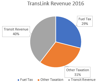
TransLink currently receives revenue from a variety of sources such as through local taxation, revenue from providing transit service, and directly from government. The two largest categories are taxation and from transit service. One of the more significant taxation sources currently is fuel tax at 17 cents per litre.

The cost of fuel has been rapidly increasing. In the past, this has resulted in a drop of revenue from fuel tax, and an increase in transit use. At the same time, people are shifting to electric and other more fuel-efficient vehicles over the next decade. This got me thinking about how TransLink will be funding the new 10-Year Transit Vision.

TransLink recently updated their financial projections over the next 10 years. I have included select information in the following charts from those projections.

TransLink Projected Revenue 2017-2026. Actual Revenue in 2016. Select image to enlarge.

TransLink Revenue 2016. Select image to enlarge.

TransLink Projected Revenue 2020. Select image to enlarge.

TransLink Projected Revenue 2026. Select image to enlarge.

TransLink has accounted for the fact that fuel tax will be a smaller part of their funding mix. This is encouraging to see. TransLink’s Mayors’ Council launched the Mobility Pricing Independent Commission in part to figure out how to replace the fuel tax.

In this day and age, fuel tax is a poor way to pay for transportation systems. As more people shift to walking, cycling, transit, and more efficient vehicles, less money will be available to fund the network. I look forward to seeing fuel tax replaced.

The Details

2016 2017 2018 2019 2020 2021 2022 2023 2024 2025 2026
Fuel Tax $396m $388m $388m $389m $390m $390m $391m $391m $392m $392m $393m
Other Taxation $430m $448m $467m $485m $512m $537m $561m $582m $603m $626m $648m
Transit Revenue $542m $566m $595m $624m $653m $675m $700m $724m $747m $768m $790m

Tuesday, May 1, 2018

Metro Vancouver Council of Councils: Climate Change, Waste Management, Affordable Housing, and Transit.

Two times a year, the Metro Vancouver Regional District hosts Council of Councils meetings. Each municipality in our region has a few members of their council who also serve as directors on the Metro Vancouver Board. These Council of Councils meetings provide an opportunity for all elected local government members to get direct updates from the district, ask questions, and hopefully receive answers. I was at the most recent Council of Councils meeting on Saturday.

Metro Vancouver Council of Councils meeting. Select image to enlarge.

The meeting opened with an update from the regional district chair Greg Moore. Due to the recent media attention around the regional district, Moore provided “fact checks” to some of the stories that have been circulating. The one fact that stood out to me was that the Metro Vancouver Cafeteria is not subsidized, it makes a profit.

The first update at the Council of Councils meeting was about the Climate 2050 Strategy. Climate change will have serious impacts in our region. Over the past decade, GHG emissions have stabilized in Metro Vancouver. This is good news, as both the population and economy have grown. This is not enough though, emissions need to go down. Metro Vancouver is starting the next phase of its climate strategy, and will be working with the public and stakeholders to develop a plan to further reduce GHG emissions in our region.

Impacts of climate change in Metro Vancouver by 2050. Select image to enlarge. 

The North Shore Wastewater Treatment Plant is one of the largest infrastructure projects ever undertaken by the regional district at $700 million. The new plant will provide secondary sewage treatment for North Shore communities as required by federal regulations which come into force at the end of 2020. One of the interesting features of the treatment plant is that it will also include a district energy component, so that heat from wastewater can be productively used. This is similar to the district energy system in the Olympic Village area in Vancouver. More information on the treatment plant is available on the project’s website.

One of the region’s goals is to divert 80% of all discarded material from ending up as waste, either in a landfill or incinerated, by 2020. As of 2016, 62% of solid waste is diverted. Metro Vancouver continues to make progress on increasing the diversions rate. As of July, polystyrene (foam) packaging will be banned from garbage.

There are many materials banned from garbage in our region. One of the ways that some people are getting away with having banned materials in garbage is to ship garbage outside of the region for processing. Metro Vancouver has introduced a new Generator Levy and Commercial Waste Haulers Licensing System to better ensure that solid waste is handed within our region’s systems.

Single-use containers such as coffee cups are becoming a significant solid waste issue. The regional district is currently working on options for dealing with these single-use items. These options will be presented this winter to the Metro Vancouver board for consideration.

Metro Vancouver is a public housing provider, focusing on housing for families with low to moderate incomes. There are about 9,000 people living in Metro Vancouver managed housing, making it the second largest subsidized housing provider, after BC Housing, in our region. With the recently announced provincial and federal housing programs, Metro Vancouver’s housing corporation is positioning itself as a manager of affordable housing on behalf of municipalities in our region. Municipalities can require affordable housing as part of redevelopment proposals. Once that affordable housing is built, it could be handed over to Metro Vancouver Housing for management.

On the topic of affordability, transportation and housing costs must be considered together. One of the big pushes in our region is to provide affordable rental housing near frequent transit such as B-Lines and SkyTrain. Metro Vancouver has been providing advocacy support by creating things such as the Regional Affordable Housing Strategy. The provincial government is in the process of creating rental-only zoning which should further help support creating affordable rental housing near transit. At the meeting, it was noted that Coquitlam has been successful in building rental housing near public transit.

There was also an update from TransLink at the meeting, focusing on recently funded phase two projects.