Thursday, February 27, 2014

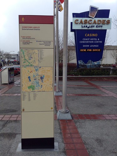
City of Langley's new wayfinding signage being installed

Local governments often talk about promoting sustainable modes of transportation like walking, cycling, and transit. While local governments love talking about sustainability, sometimes it just remains talk.

Way back in 2011, the City of Langley commissioned a wayfinding strategy. Currently, the City has a hap-hazard assortment of mostly auto-oriented wayfinding. The wayfinding strategy proposed an integrated wayfinding network for all modes of transportation. Wayfinding signage would direct people to and around the City’s downtown core. It would also guide people around the City’s trail network; connecting downtown, local parks, and the Nicomekl floodplain.

Proposed wayfinding signage. Click image to enlarge.

Proposed downtown walk/cycling information signage. Click image to enlarge.

Last year, the City approved funding to get this project started. Last night on my way home from work, I noticed the first of the new pedestrian wayfinding signs and maps installed. I decided to take some pictures this morning.

Downtown Langley - Walking Map and Wayfinding Sign at Fraser Highway and Glover Road (Looking West)

Wednesday, February 26, 2014

Road Pricing in Metro Vancouver Report Released

In late October, I attended a workshop called “Moving in Metro: A discussion on mobility pricing.” This series workshops was put on by the SFU Centre for Dialogue. The workshops gave people a brief introduction to the different types of mobility pricing, their benefits, and their drawbacks.

With the government at all level tightening their budgets, the desires to reduce congestion, and the need for improved transit and well-maintained roads, many local politicians and transportation planners are looking at road pricing as a way to meet all these goals.

The SFU Centre for Dialogue recently released a regional dialogue report which outlines the results of the workshops that the organization hosted last year.

The report outlines people’s views about bridge/tunnel tolls, high occupancy/toll lanes, area scheme, and full network pricing. The workshops and the report are not meant to provide guidance on a recommended road pricing scheme, but simply outline likes and dislikes regarding the different options.

According to the report, the majority of participants at the workshops used the auto as their primary mode of transportation. At the workshops, participants were asked to graph their typical journeys. What because apparent is that most people use more than one mode of transportation. This information is often not captured with transportation mode share statistics as information is usually only on the primary mode of transportation when commuting. Clearly people’s travel are more complex than statistics would suggest. These complex travel patterns mean that government really needs to be focused on building a multi-modal transportation network.

While the transit referendum will likely not deal with road pricing, one of the key take-aways from the workshops is that education is key when people have to make a choice about complex issues such as road pricing or paying for transit. For example, after the workshops, 47% of participants increased support for road pricing while only 3% walked away with less support for road pricing.

At the workshops, participants were asked what key principles should guide road pricing in Metro Vancouver.

Two broad principles clearly stood out: there was almost unanimous agreement that a potential road pricing system in Metro Vancouver should be guided by the principles of fairness as well as transparency and accountability.

In more detail, participants thought that all transportation network users should pay user fees for the services they used. Of course affordability was also a concern, and it was noted that the transportation network should allow access for vulnerable groups such as seniors and other people with limited incomes.

Another key point was that there needs to be regional equity. People in Vancouver shouldn’t get a “free lunch” while people in the South of Fraser pay bridge tolls for example.

Participants also wanted to see that money collected from the use of transportation was directly used to fund transportation. They also wanted to ensure that we had a multi-modal transportation system that gives people travel choices.

The key take-away for me is that education is key for any discussion about transportation financing in the region, and will be the key to winning the transit referendum next summer.

Tuesday, February 25, 2014

TransLink, improv comedy, and the upcoming referendum

This last weekend, I had out-of-town family visiting. We decided to take transit from Langley to see an improv comedy show at Vancouver Theatresports League on Granville Island. These shows usually result in non-stop laughter, and this time was no different.

One of the improv games involved the players incorporating phrases from the audience (that were written down without knowledge of the players) at random points in the scene. The audience also had to suggest a setting for the scene. I didn’t suggested it, but the selected scene was at a SkyTrain platform.

As the scene progressed, the SkyTrain arrived at the platform. As the SkyTrain has an iconic door closing sound, this was the perfect time to replace the sound with the random audience phrase of “I’m Sorry.” One of the players then said, “It sounds like that because it's a Canadian train, but because it’s TransLink, they doesn’t really mean it.” This of course got the audience laughing. It was interesting when one of the players said TransLink as there were lots of boos from the audience. The transit referendum popped into my mind.

The improv scene reinforced two thoughts I have about transit in Metro Vancouver and the upcoming referendum. Transit is a pervasive part of life in Metro Vancouver. Much like New York is associated with its subway system, Vancouver is associated with its automated rail network.

Our system is reliable and safe. Not that improv comedy is the most scientific of indicators, but the improv players could have easily made a joke about the train not showing up or something about crime. In fact, the whole scene played out like SkyTrain was just a normal part of life for a regular person in Metro Vancouver. The major joke was that one of the players didn't know how to use SkyTrain.

It wasn’t all good though. It was interesting to hear the reaction to the joke about TransLink not caring about its customers. It should come as no surprise that many see TransLink as an unaccountable, wasteful organization even if this is not the case.

So what does this have to do with the upcoming referendum?

I believe that the majority of people in our region would approve a new source of funding to expand transit today if it was not for the TransLink brand. I believe people would actually vote no to a new source of funding today, not because they don’t support transit, but because they don’t believe TransLink is an accountable organization. A similar thing happened with the HST referendum in BC. Most people supported the tax, but did not like how the BC Liberals implemented it. This is why it failed at referendum.

With the province’s commitment to reform TransLink governance this year, the agency should become more accountable to the public.

Once the reforms are implemented, the province, local government, and TransLink have to show the public that TransLink is accountable and can be trusted with new revenue to fund transit expansion. As the referendum will now likely occur in the summer of 2015, this should be enough time to change views on TransLink. If this does not occur, I fear that we will not see much needed transit expansion in the region.

Many advocacy group have spent a lot of time focusing on why transit is good for the region. While this information is useful, most people in the region are already convinced that transit is critically important. I think these groups need to focus on the benefits of a regional transportation authority like TransLink which is the model that other regions in the world look to.

Monday, February 24, 2014

City of Langley Council rejects all advisory committee recommendation?

Over the past several meetings of the City of Langley’s Parks and Environment Committee, which I sit on, we reviewed the City’s new Park, Recreation, and Culture Master Plan. We submitted two requested to City Council:

THAT the Parks and Environment Advisory Committee recommends that Council review, consider and receive the recommendations made by the committee with regard to the prioritization and phasing of the Key Recommendations within the Parks, Recreation, and Culture Master Plan.
THAT the Parks and Environment Advisory Committee recommends that Council consider the following items be added to the Key Recommendations within the Parks, Recreation, and Culture Master Plan.

You can read more about our recommendations in a post I wrote last week.

I heard word late last week that while Council did received our recommendations, they decided to not move forward with any of the recommendations of the Parks and Environment Committee at the last Council meeting. Councillor Dave Hall put forward the recommendations of the committee, but no other councillor seconded the motions. They effectively died on the table.

While the City’s advisory committees are just that, advisory, it is very disappointing to see the countless hours of volunteer work that our committee put into giving feedback to the Park, Recreation, and Culture Master Plan simply be ignored. While some of the recommendations we made may result in an increase in the City's budget, may are common sense recommendations that may actually save the City money in the long run.

As last week’s Council meeting also dealt with the proposed budget for this year, I can only hope that the Councillors will be looking over our recommendations. I hope that they will at least bring some of the recommendations forward for adoption at a future Council meeting.

Thursday, February 20, 2014

BC Budget 2014: Roads and Transit Spending

On Tuesday, the BC Government released its proposed budget for 2014/15. While much has been said about the budget, I want to focus on the transportation portion.

I remember in the Campbell era when it was announced that the province was going to shift to being more committed to investing in public transit. Things appear to be slowly drifting away from that vision.

In 2011/12, BC Transit received $161 million to cover its operating expenses. In 2012/13, BC Transit received $121 million for its operating expenses. In 2013/14, BC Transit received $112 million for its operating expense. The proposed 2014/15 budget will increase funding to $116 million, but it appears that transit operation spending is on a downward trend. At the same time, the Ministry of Transportation's overall operating budget has increased modestly from around $806 million to $812 million.

In addition to decreasing direct operational spending on transit, the province has put up roadblocks to finding a long-term funding solution for TransLink to expand transit service in Metro Vancouver. This has led to a reduction of per-capita service in the region.

Instead of the province becoming a leader in supporting transit service, the province is slowly turning its back to supporting sustainable transportation in the province.

When it comes to transportation project spending in the province, things are a bit different. For highway projects, the province spent a total of $690 million in 2011/12, $715 million in 2012/13, and $638 million in 2013/14. The government is proposing to spend $567 million on roads in 2014/15. The decrease in highway spending is due to the completion of the many Gateway Program highway projects in Metro Vancouver such as the South Fraser Perimeter Road (excluding the Port Mann/Highway 1 Project).

The next major highway project will be the George Massey Tunnel replacement, and the government is committing to spend $18 million in 2014/15 to develop the project. The Massey Tunnel replacement bridge is likely a decade out according to the province. One of the scary things is that the replacement project doesn’t appear to be well thought out as even the Ministry of Transportation says that its “too soon to estimate how much the project will cost.” It could likely be another Port Mann boondoggle.

I haven’t mention the over $3 billion dollar Port Mann/Highway 1 project because it is the responsible of Transportation Investment Corporate, a crown corporation. The project is meant to pay its own way, but due to the massive reduction of vehicles using the bridge, it will cost all BC taxpayers $79 million in 2014/15. To put this into perspective, the province is proposing to increasing Medical Service Plan premiums by 4%. That increase could have been halved if it wasn’t for the Port Mann/Highway 1 project’s financial underperformance.

I do have to give the province some credit though. The province has increased spending on dedicated cycling infrastructure from $3 million in 2011/12 to $9 million this year. Also, the province has increased spending on transit capital projects from $191 million in 2011/12 to $420 million in 2014/15. This major increase is mostly due to the construction of the Evergreen Line.

While it is good that the province is committed to spending on capital transit improvements, without operating funding, it will be difficult for BC Transit or TransLink to actually take full advantage of the provincial funding.

With money being spent on bridges that people don’t want to take, and with taxpayers likely to be on the hook for the costs of the George Massey Tunnel replacement, I have to wonder if that money could have been better spent on supporting transit service throughout the province.

Wednesday, February 19, 2014

Pattullo Bridge Average Traffic Volume up 14% Weekdays, 16% Weekends

Much has been said about the traffic diversion from the Port Mann Bridge over to the Pattullo Bridge. Unfortunately, no one has looked at the overall traffic pattern changes that have occurred since the new, tolled Port Mann Bridge went into service.

TransLink has been posting weekly traffic counts on the Pattullo Bridge. The information is hard to find. The information is also very detailed which doesn't lend itself to getting a high-level overview of the changes that are occurring.

As I posted about last week, average daily weekday volume over the Port Mann Bridge is at levels not seen since the mid-1990s. The same cannot be said about the Pattullo Bridge.

Since the province opened the South Fraser Perimeter Road and started promoting the Pattullo Bridge as a “free alternative” to the Port Mann, traffic volumes have skyrocketed.

Pattullo Bridge Average Traffic Volume. Source: TransLink. Click graph to enlarge.

The date ranges I focused on in the graph are important. The first range is the traffic volume over the Pattullo while the Port Mann was still free. The second range is the traffic volume over the Pattullo after the province introduced a $1.50 toll on the Port Mann. The third and fourth ranges show the effect of traffic volume on the Pattullo as a result of the province raising the toll on the Port Mann to $3.00.

It appears that both changing the direct cost of using the Port Mann from free to $1.50, and from $1.50 to $3.00, resulted in a 3% increase in traffic over the Pattullo each time.

It is no surprise that people in New Westminster have been complaining about the increase in traffic and its negative effects. Would you want over 9,000 more vehicles coming down the street in your neighbourhood?

Speaking about the Pattullo Bridge, TransLink, Coquitlam, New Westminster, and Surrey have restarted the public consultation process for the replacement of the Pattullo. More information is on the Pattullo Bridge Review website. Surrey is still pushing for a bigger bridge while New Westminster does not want to see even more traffic being rammed through its community.

Looking at the shift in traffic patterns, it should be clear that we need a comprehensive road pricing system in our region. Hopefully the province will wake up to this fact. In the meantime, TransLink should consider tolling the Pattullo Bridge today to start raising fund for its eventual replacement, and to manage the traffic demand which the province has dumped onto our regional transportation network.

Tuesday, February 18, 2014

Langley City Park, Recreation, and Culture Master Plan Recommendations

Last year, I posted about the Park, Recreation, and Culture Master Plan that the City of Langley commissioned. The plan was received by City Council in November. While the City’s Park and Environment Advisory Committee was part of the process, we felt that there were items that still needed to be addressed in the plan. We also felt that some of the priorities needed to be adjusted.

Our full recommendations can be viewed in the latest council meeting agenda, but I wanted to highlight some of the major items we wanted changed in the plan, and give some of my thoughts.

Trails, Paths & Sidewalks:

The Parks, Recreation and Culture Master Plan and the Master Transportation Plan must be cohesive with regard to promoting sustainability in the City.

Ensure connectivity with the proposed Brookswood/Fernridge plan to link trails between the Township to City

One of the challenges in Langley has been the disconnect between talking about sustainable practices, and putting those practices into action. This is obvious in our transportation network. By ensuring that the transportation plan and the parks plan work together, it will hopefully make our transportation system more supportive of walking and cycling.

The parks plan is all about connectivity and encouraging people to visit our parks system. It is important that the on-street network and off-street trail network connect our parks together. It is also important that this system connect to other municipalities. It would be silly if a road dead-ended just because it arrived a municipal border, but so often this happens with our walking and cycling network.

Parkland:

In commercial and industrial developments, negotiate with developers to provide some on-site green space for use by employees and customers, including seating areas with trees.

PEAC felt that developers should be encouraged to ensure the green space is in an area of high visibility to the general public and that CPTED procedures be considered.

One of the things that I felt strongly opposed to was creating semi-private green space that would effectively disconnect buildings from the street. Poorly planned green space can actually do more harm than good in a community. There was a bit of discussion about adding on-site green space in non-residential developments.

North of Fraser Highway, there is very little park land. All on the committee want to see that change. The compromise was to ensure in our recommendation that any semi-private green space be high visible, so it would not become a crime magnet. I still would have preferred to see development cost charges being used to create high-quality public parks, and not to have a series of under-utilized, semi-private green spaces.

Park Design & Development:

Design parks with the goal of increasing creativity, interest, and cultural reflection, e.g., more inter active play environments, allow children to experience more nature, water art, let parks flow out onto street, cultural art.

PEAC would like Council to consider natural play equipment in the future. (natural features and components (rocks, logs) to create playscapes).

Other Park Amenities:

Encourage the planting of fruit and nut trees as part of urban agriculture projects, where there is a plan for appropriate maintenance and harvesting.

Include fruit trees in the Annual Tree Planting program.

It was noted during discussion that past plans for Douglas Park included putting in an orchard. Overall the committee felt that more urban agriculture projects like mini-orchard and community garden are needed in Langley.

Consider an outdoor fitness area in Douglas Park close to the Douglas Recreation Centre.

When developing new parks consider outdoor fitness areas in all City parks.

Environmental Stewardship:

Develop a management plan for the Nicomekl Floodplain.

Establish a staff position for an Environmental Coordinator potentially starting at half time. Positions wages could offset consultant fees.

Monday, February 17, 2014

Making a Bad Situation Worse: "Temporary" Parking Motion

Last week, I posted about how the Township of Langley created a situation that it could have avoided by provisioning “temporary” on-street parking in some neighbourhoods in the community. One of the things that I’ve learned in life is that temporary usually become permanent. Even though the Township marked the on-street parking it provided a “temporary”, some of that parking has been there for over a decade. People started to expect that this parking was to be provided forever. When this parking disappeared, people got very upset.

On February 3rd, a resident near 80th Avenue and 212 Street in the Yorkson area requested that council approve more parking in the area. As I noted last week, the Township already requires a generous amount of off-street parking in each new development. I was a little shocked when I saw the following motion that will be voted on this afternoon by Township Council:

Councillor Richter provided the following Notice of Motion for consideration at the next Regular Afternoon Council meeting:

Be it resolved that Council ask staff to proceed with the provision of twelve temporary, on-street parking stalls at the corner of 212 Street and 80 Avenue as described in the February 3, 2014 memo to Council at a cost not to exceed $50,000; and Be it further resolved that six of these temporary parking stalls be designated Visitor Parking and six be designated Resident Parking.

There are a few problems with this motion. The first is that the motion doesn’t address the root cause of the perceived lack of parking in the area. It further exacerbates the situation as these residents will expect this “temporary” parking to last forever. What will happen when the Township removes the parking?

While it is normal for local government to restrict parking for residents or permit holders on a block, these restrictions are normally part of a coordinate and comprehensive parking policy. This motion is ad hoc, and if approved, would open the floodgates for other petition in the Township to start mini-parking fiefdoms. At $50,000 per request, is this something the Township really want to get in the business of doing?

The real long-term solution is to develop a parking demand management strategy in the Township that will be fair to residents. The plan should enable the best use of on-street parking which is a limited, highly valuable resource. Approving this motion would be a mistake.

Thursday, February 13, 2014

Kinder Morgan Trans Mountain Pipeline

As you are likely aware, Kinder Morgan is looking at twinning their Trans Mountain pipeline which cuts through Metro Vancouver. It is the only oil-product pipeline that connects Northern Alberta to the West Coast.

The current corridor and proposed expansion cuts through Langley and Surrey. Because the expansion of the pipeline will cause impacts in the South of Fraser, Surrey is seeking intervener status at National Energy Board hearing on the pipeline and the Township of Langley is considering seeking intervener status.

Kinder Morgan Trans Mountain Pipeline through Surrey. Click map to enlarge

Kinder Morgan Trans Mountain Pipeline and proposed new alignment through Langley. Click map to enlarge

The current pipeline and proposed expansion will cut through one of the Township of Langley’s highest populated areas, Walnut Grove. The current pipeline and proposed expansion also cross six different aquifer, several of which provide drinking water in the Township. The pipeline also intersects with 26 public roads and bridges. Having the oil pipeline running underneath these roads and bridges will drive up maintenance cost and increase the risk of an oil spill.

The Township and its residents take on the risk of this proposed expansion, but see no direct benefit. Township staff complied the following list of preliminary issues due to the proposed expansion. You can read the full staff report in the February 3rd Council Afternoon Meeting Agenda.

  1. Disruption during construction to residents and businesses.
  2. Business losses incurred during construction.
  3. Contamination of groundwater used for water supply and farming purposes.
  4. Potential for spreading of Invasive Species during construction.
  5. Destination of excavated materials for pipelines constructed in flood plain.
  6. Emergency response time in floodplain during winter months for a spill.
  7. Loss of significant trees where new pipeline is proposed to go through existing forested areas.
  8. Loss of potential to plant trees over pipeline where route extends through new and existing park areas.
  9. Future permitting restrictions and loss of potential to use new corridor through park areas.
  10. Environmental impacts to watercourse crossings and loss of surface vegetation to facilitate future monitoring of pipeline.
  11. No identifiable immediate benefit to the Township of Langley resulting from project.
  12. Impact on existing Township lands and roads for staging of construction activities.
  13. Environmental impacts to existing designated municipal natural park areas that are expected to be protected as is.
  14. Disruption to existing users and tenants of municipal lands with resulting loss of revenue and ongoing customer base.
  15. Future upgrades to roads and underground infrastructure will be more challenging with increased costs and potential for delays where crossing the new pipeline.
  16. Public communication during the anticipated construction window.
  17. Ability to impose municipal bylaws and policies on this project.
  18. Ability to recover costs associated with relocating Township infrastructure (i.e. water mains) by Township crews.
  19. Fisheries and Oceans Canada (DFO) agreement with National Energy Board transferring oversight for fish and fish habitat for this project.
  20. Insurance coverage and liability issues.

Wednesday, February 12, 2014

Parking in Willoughby Update

Over the holidays, Township of Langley Council heard from some residents in the Yorkson area of Willoughby about the perceived lack of on-street parking in their community. The removal of “temporary” on-street parking along 80th Avenue is what prompted residents to head to Township Council to make their concerns known. I wrote about this earlier in the year, but the gist is that the parking problem is a demand-side issue and needs to be managed. It is also a result of the current lack of walkable centres in the community. Of course the Township has approved, and walkable centres are starting to be built in Willoughby.

As a result of residents’ concerns, a rather lengthy motion by Councillor Kim Richter was passed to have the matter discussed at a Council Priorities Committee Meeting. The motion also included a provision for Council to have a van tour of the area to see the parking issue first hand. Hopefully the tour will be guided by Township staff as most Councillors own a vehicle and could very easily drive themselves through the Yorkson area.

The latest agenda for the Council Priorities Committee Meeting has a staff report that outlines the parking situation in the Yorkson area.

Single Family Homes: 3 to 4 parking spaces per lot.
Rowhouses/Townhouses: 2 to 2.5 parking spaces per unit, plus one visitor parking space for every five units.
Apartments: 1 to 1.5 parking spaces per unit, plus visitor parking spaces based on 10% of the total parking provided in the building.

These parking requirements are pretty consistent with other auto-oriented communities in North America. The primary parking issues in Yorkson are that a.) people are converting garages to storags and other uses and b.) illegal secondary suites. I’ve talked enough about on-street parking permitting, and I still believe this is one solution that the Township needs to consider.

The staff report also notes that the design standard for all major (arterial) roads in the Township is to not have on-street parking due to perceived safety concerns, and to keep traffic moving at a high speeds. When arterial roads are not fully built-out, the Township allows temporary parking until such a time as the road are complete. I think one of the issues is that the Township did allow “temporary” parking in the first place; some of this “temporary” parking has been there for over a decade. Taking something away like parking will always create an conflict. The Township may have prevented this conflict by banning parking on future arterial roads from day one.

Of course, the Township could also consider adopting the boulevard as a future arterial standard. It would allow safe access for pedestrians, cyclists, parking, lower-speed, and higher-speed traffic. Combined with mixed-use development along some boulevards, and the Township would become one of the most accessible communities in Metro Vancouver.

Example Boulevard from NACTO Urban Street Design Guide. Click image to enlarge.

Anyway, it will be interesting to see what Council will do with parking in Yorkson. The worst thing they could do is up the amount of required off-street parking as it would turn Willoughby into a community that has more area dedicated for cars than people. Also, people would just continue to using enclosed parking space for other uses.

Tuesday, February 11, 2014

Port Mann Bridge: Traffic volume lowest in two decades

Transportation Investment Corporation, the BC crown corporation that is response for the Port Mann Bridge, recently released a report about traffic volume across the bridge.

2005 – 2014, January Average Daily Weekday Traffic Volume on Port Mann Bridge. Click graph to enlarge.

The whole justification used to replace the Port Mann was because traffic was suppose to continue to grow across the bridge. What is interesting is this is not the case. In fact even before the toll was introduced on the Port Mann, traffic volumes were dropping.

The average daily traffic volume in 1996 was 105,797. Traffic volume on the Port Mann today is at the lowest level in about two decades.

Besides the toll which is limiting growth, statistics are showing that since the mid-2000s traffic volume have been declining across North America. It seems that the Port Mann is just the latest example.

Reading the report that TI has put together, traffic volume during the weekday has dropped about 3% since tolls were introduced, weekend traffic has dropped 10%.

Just like the Golden Ears Bridge, the financial solvency of the Port Mann Bridge is based on increasing traffic volumes. Between the Golden Ears Bridge and the Port Mann, I have to wonder if taxpayers are going to be on the hook for billions of dollars due to poor planning. It is no surprise that province couldn’t find a private corporation to do a P3 with for the Port Mann project.

Traffic volumes have increased 1-2% on the Alex Fraser and Pattullo Bridge, but traffic volumes are down across the George Massey Tunnel.

Traffic volume peaked in 2004 through the Massey Tunnel, and have been dropping ever since. This is interesting because the province is looking at expanding and tolling this corridor.

If the province was actually interested in building a 21st century transportation system in Metro Vancouver, they would put a small $1.50 toll on all river crossing to manage congestion. They would use that money to keep our transportation system in a state of good repair. They would also work with the region to increase transit service (for which there is actually a demand.)

Monday, February 10, 2014

Road Pricing in Metro Vancouver

Metro Vancouver’s mayors have been pushing hard for road pricing as a way to pay for transit and other transportation improvements in our region. Road pricing can take many forms from distance-based pricing based on kilometres driven, tolling like on the Port Mann and Golden Ears Bridge, or cordon zones like the Congestion Charge in Central London.

If you are looking for some light reading this Family Day, I suggestion you read “Congested and Nowhere to Go: Congestion, Road Infrastructure, and Road Pricing in Metro Vancouver” by Jonathan Arnold. Arnold wrote the report while completing an SFU co-op term at the Business Council of British Columbia.

Arnold points out that there could be an additional 700,000 more vehicles in our region over the next 25 years. He points out the economic, environmental, and social costs of congestion, and points out that it is impossible both economically and physically to build enough "free" roads in the region. Arnold then explains road pricing, and builds a case for using it in Metro Vancouver.

While road pricing makes a lot of sense —we can see its power in reducing congestion along corridors like Highway 1 today— the province does not seem to see the benefit of a comprehensive, integrated roads pricing system for Metro Vancouver.

In a letter from last week between Transportation Minister Todd Stone and TransLink’s Mayors’ Council, Stone said, “the provincial government will not permit new funding to be collected from the provincial transportation system situated in the region.”

At first glance, it looks like road pricing is off the table. Provincial bridges like the Lions Gate and Iron Workers Memorial could not be tolled. The irony is that in the South of Fraser all river crossings, expect for the Alex Fraser Bridge, will likely be tolled in the next decade or so. We will end up with an unfair, ad-hoc “road pricing” system in the region.

While the BC government is starting to listen to the region about transportation issues, it seems like the province is not interested in using road pricing as a way to reduce congestion and pay for transportation in Metro Vancouver.

Thursday, February 6, 2014

City of Langley 2014 Budget

The City of Langley has released it draft 2014 – 2018 Financial Plan. New this year, the City has put together an eight-page budget highlight document. It is well worth the read as it lays out the City’s budget process, where taxes go, what some of the big-ticket capital projects are, and why local taxes are increasing.

This year the City is planning to increase property tax by 2.71%. 0.75% of that increase is to cover infrastructure renewal which is desperately needed in the City.

Over the years, the City has been slowly balancing the amount of property tax it receive from residential and commercial properties. In 2014, it is proposed that 51.6% of taxation revenue come from residential properties. Even with the tax increase, due to assessed housing values changes, a strata owner will on average see no increase on his tax bill while a single-family owner will on average see a $50 dollar increase on her tax bill. Commercial property owners will see an average $630 increase on their tax bills. In total, the City plans to collect $22.8 million in property taxes.

Besides property taxes, the City's second largest source of income is the Casino which will contribute $5.8 million to the City’s bottom line. City of Langley residents contribute about $2.8 million to TransLink for transit and roads. The City of Langley will receive $298,000 to maintain the major road network from TransLink. The City will also receive $411,610 from the Township of Langley for Langley Youth and Family Services, Emergency Planning services, and RCMP building cost sharing.

Of the $28.3 million in operation expensive proposed for 2014, $578,145 is directly attributed to maintaining a city council. That works out to 2% of the overall operating budget.

Every year the City proposes a list of capital works projects. This year, the City has allocated $14.3 million for the reconstruction of Timms Community Centre. This one project represents about 2/3rds of the proposed 2014 capital budget. As this is such a larger capital project, I’m surprise that there is pretty much no information about the new Timms Community Centre available online.

Other proposed major projects include the rehabilitation (including water and sewer main replacement) of 200th Street between 50th Avenue and 56 Avenue for a total of $3.7 million. The City also plans to continue to implement its Public Realm Plan by continuing to upgrade the street lights and installing bike racks in the Downtown core. The City plans to start implementing its wayfinding strategy this year.

One of the things that I get disappointed about is that every year the City plans to spend $400,000 on cycling and pedestrian improvements, and every year that funding gets pushed back to a later year. This year is no different.

The full draft financial plan is available on the City’s website. At the February 17th council meeting, the plan will be presented and the public will have an opportunity to provide feedback.

Wednesday, February 5, 2014

TransLink, trust, and the referendum

This probably comes as no surprise, but at my work Nathan and transit can be synonymous at times. People regularly come up to me with their transit questions and even transit complaints. Sometimes people can get pretty passionate and mistake me as TransLink (which I am not.)

Yesterday I was at work and one colleague said loudly to another, “Nathan wants to increase my taxes that go to TransLink.” He continued to go one about how TransLink delivers nothing but broken promises and was a black hole for money. Of course, this was to get my attention.

I said, “Weren’t three audits of TransLink enough?”

The colleague shot back, “They were government audits and can’t be trusted. I want an audit done by a real businessman before I’d give one more dime to TransLink.”

He then went on to explain that he knows a guy who knows a guy at TransLink. This guy basically said that TransLink burns $20 bills instead of diesel fuel because it is so wasteful.

This is an exaggeration, but the point is that many people don’t believe that TransLink is a good stewards of taxpayer’s dollars.

Interestingly through the whole conversation with my colleague, he implied that he actually valued transit and would be willing to increase funding for transit.

I’ve said in the past that the TransLink brand would likely be the root cause for a lose in the upcoming transit referendum. I’m even more convinced of this after my conversation yesterday. People don’t trust TransLink, and I don’t think that yet another audit would improve that trust.

One of the major issues with TransLink is a lack of direct accountability to the public. Hopefully this will change as Transportation Minister Todd Stone hinted last week that governance reform is coming soon for the agency.

Another positive sign is that the Premier has hinted at delaying the transit referendum until after the municipal elections this fall. As it stands now neither the province nor the region’s mayors are championing increasing transit funding. The delayed referendum combined with the governance reform will hopefully allow TransLink to become more trusted in the eyes of the public. It hopefully will also allow all levels of government to champion increasing transit funding.

Having a referendum on only transit is silly, as no other part of our transportation system goes to referendum. Ideally the whole idea would be ditched, the province’s update to TransLink’s governance would restore accountability to the public, and a long-term funding source could be secured to allow improved transit service in our region.

Tuesday, February 4, 2014

Building villages and the shifting demographics in Canada

One of the things that I’ve been thinking about lately is what makes a walkable community that people love. The simple answer is to put where people live within walking distance of shops, services, recreations, and employment opportunities; and tie all these walkable areas together with streets that give priority to transit, cycling, and walking, so people get more access to places they want and need to go. What does that look like?

In Metro Vancouver, visions of Downtown Vancouver and Metrotown come to mind when talking about walkability. This is not the only way to build a walkable community. In fact, the “Vancouverism” style of development is rare.

I’ve explored many regions in North America, and I’m starting to understand that it is really about creating villages. Villages come in difference shapes and sizes, but they share some common attributes. Villages are centred around ground-level, street-front retail on a “main street”. The “main street” retail stores may have more shops, offices, apartments, or nothing above the main floor. Just off the “main street” will be higher density housing like rowhouses, low-rise, or mid-rise apartments. There will also be single-family housing further away from the “main street”, but still within walking distance. To get the benefit of living in a large urban areas, all these walkable villages are linked together with transit.

Of course there are also parks, high-rise apartments, larger-format retail, schools, and other amenities that will impact the looks and scale of these villages, but the basic build blocks are the same. For example, Fort Langley and White Rock are both examples of a village. The Broadway corridor is a linear village. Even Downtown Vancouver is a series of villages.

When looking at places like San Francisco, Boston, Philadelphia, and even New York, many of the most walkable areas don’t have any high-rise apartments. What I did notices was a lot of row houses and walk-up, low-rise apartments. This is something we should take note of in the South of Fraser.

The following two graphs are from the CMHC Canadian Housing Observer 2013.

Share of each household type (%) Canada, 1971 and 2011. Select graph to enlarge.

Structure type by household type, Canada, 2011. Select graph to enlarge.

There are way less couples with children, and way more one-person households. This is a trend that the CMHC believes will continue. The majority of one-person households live in low-rise apartments.

Our population is aging, so people will need to live in walkable communities to have fulfilling lives as many will no longer be able to drive. The younger generation also wants to live in walkable areas for different reasons. All put together, there is a shift away from peopling wanting to live in the typical auto-oriented suburb.

In the South of Fraser, we have done a good job of creating a variety of housing choice, but we have failed at creating villages. We have failed because we have not created “main streets”. In fact, we are still building auto-oriented strip malls. It is not too late though, there are still development opportunities in the South of Fraser to create villages. I believe we must shift how we are developing the South of Fraser, so we can provide the quality of life that people want and deserve.

Monday, February 3, 2014

Roberts Bank Terminal 2 Project Pre-Design Consultation Summary

For the last several years, Port Metro Vancouver has been going through a consultation process for the proposed Roberts Bank Terminal 2 Project. This project will see a new three-berth container terminal at Deltaport and will increase the container handling ability of the Port by 2.4 million TEUs (twenty-foot equivalent unit containers) annually.

The Port’s consultation process is in addition to the Canadian Environmental Assessment Agency review process which starting in earnest this January.

As part of the Port’s consultation process, they hosted a series of open houses and small group meetings late last year. The feedback received from the open houses and meetings have been summarized with a report which can be downloaded. The main themes from the public consultation are:

Road and rail traffic: Participants expressed concerns regarding the local impacts of increased truck and train traffic as a result of the proposed project, including increased congestion, air pollution and noise impacts. There were also questions raised about whether or not existing transportation infrastructure could accommodate an increase in traffic and whether there were ways to put more containers directly onto trains.

Scope and nature of the environmental assessment: Participants were interested in understanding the scope and nature of the environmental assessment, including an assessment of the economic, social and environmental impacts of the proposed project. Some participants also wanted more information and clarification about the Canadian Environmental Assessment Agency’s public comment period on the Project Description.

Alternatives to the proposed Roberts Bank Terminal 2 Project: Participants expressed concerns that alternatives to the project have not been adequately considered and that options for increasing container capacity on Canada’s West Coast should be focused on Prince Rupert and Fraser Surrey Docks, and on creating efficiency improvements at existing container terminals within Port Metro Vancouver’s jurisdiction. Several participants also questioned whether the removal of the George Massey Tunnel would allow more and larger container ships to access Fraser Surrey Docks.

Habitat banking: Some participants raised questions about Port Metro Vancouver’s Habitat Banking Program and the manner in which the Program could be used to mitigate the impacts of the proposed Roberts Bank Terminal 2 Project. There was also the suggestion that Port Metro Vancouver consult with local naturalists and environmental groups to learn about their preferences regarding habitat mitigation and enhancement projects.

Project justification and rationale: Participants expressed skepticism regarding the validity of Port Metro Vancouver’s container traffic forecast and requested more information about the forecast data and the business case for the project.

Environmental impacts: Participants expressed concerns about the environmental impacts of the proposed Roberts Bank Terminal 2 Project on the Fraser River estuary, particularly related to bird and fish species in the area, and suggested that Port Metro Vancouver consider opportunities to preserve and showcase the natural environment at Roberts Bank.

Maybe I’m a bit cynical, but I’m 100% sure that this project will be approved. I hope that the Port will address the concerns brought forward by people in our region. I also hope that the Canadian Environmental Assessment Agency will require the Port to mitigate the negative impacts from the proposed expansion of their facility in Delta including the increased rail traffic that will go through communities like Langley.