Thursday, June 27, 2019

Concept plan revealed for the Nicomekl River District

For the last two days, Langley City’s proposed Nicomekl River District has been going through a “charrette” to come up with a concept plan to enhance the Nicomekl River, its tributaries, surrounding protected areas, and adjoining neighbourhoods. This “charrette” was an intense two-day process involving the participation of members of the public, council, city staff, and technical experts to develop a concept plan which will be refined over the next year.

Yesterday, I posted about the public workshop which was held on Tuesday to launch the “charrette”. That post provides the context for today’s post about last night’s open house which was held at City Hall.

I was happy to see that the open house was well attended. People were able to learn about the workshop process, and see the work of the technical team in consolidating the ideas from the workshop into one concept plan.

People attending the open house for the Nicomekl River District. Select image to enlarge.

The original plan was to have two concepts, but it became apparent early on that their was strong consensus amount all the workshop participants on how to best enhance the areas around the Nicomekl River. This is pretty amazing as during the workshop people where split into different tables that worked independently.

At the open house, people were encouraged to provide feedback.

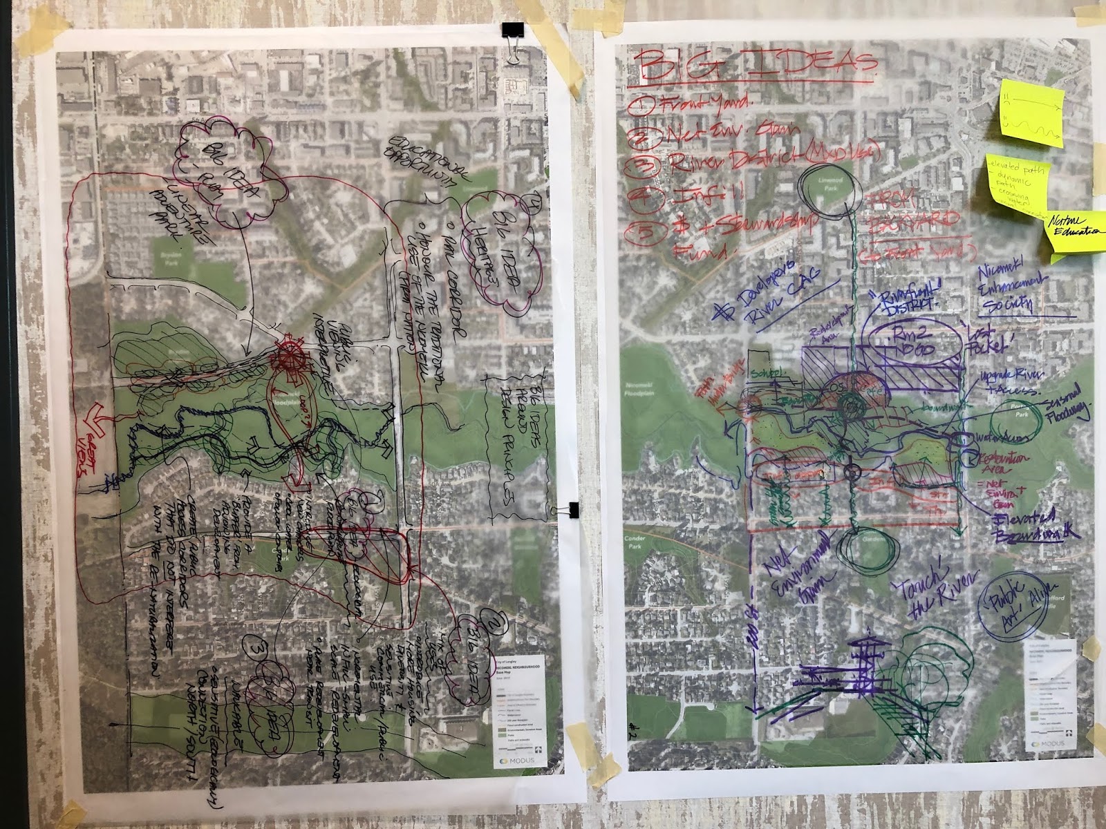
Nicomekl River District Design Principles. Select image to enlarge.

The proceeding photo shows the design principles for the Nicomekl River District. The photo was taken early during the open house. I kept my eyes on this board, and while the intensity of the dots increased, the distribution did not change much. The five design principles are:

Walkable & Accessible
People-oriented street designs and inviting pathway connections will make walking a delightful activity and allow people of all abilities to move around safely and comfortably.

Mix of Uses
A mix of uses, including small-scale shops and cafes within the neighbourhood will help create a complete community. A place where individuals and families can get their daily needs all within a short walking-distance from home.

Ecologically Sensitive
Careful stewardship of the Nicomekl River and its floodplain will ensure it stays healthy and full of bio-diverse life for generations to come.

Heritage Conscious
Recollecting the past and animating the landscape with the stories and imagery of those who inhabited the area prior to us will help us understand the present and provide context for the future.

Playful & Safe
Planning and designing for fun and whimsy across all ages will help bring people together and foster a sense of security and ownership in the community.

The following board from the open house provides a brief overview of the workshop.

An overview of the workshop held on Tuesday. Select image to enlarge.

The concept for the Nicomekl River District is split into four different rooms. Each of these rooms has a different focus on how to connect people with the river system, but all include enhancing the natural systems.

The Nicomekl River District concept plan. Select image to enlarge.

The four rooms of the Nicomekl River District. Select image to enlarge.

To help build a complete community, village centres for small-scale shops were proposed for the areas at 200th Street and 50th Avenue, and 208th Street and 48th Avenue. This could be mixed-use areas with shops on the ground level and housing above. The areas highlighted in orange represent places where there is an opportunity to increase the mix of housing types by introducing low-rise apartments, townhouses, and/or rowhouses. This could even include low-rise mixed-use buildings in some areas to improve walkability and enhance the small-town feeling of our community.

One of the other important features of this concept is to start connecting Langley City together. Today, our community can almost feel like it is two different places. This concept looks at connecting our downtown with the Nicomekl River system, and with our southern neighbourhoods.

Based on feedback gathered from the open house, this concept will now start the refinement process. As I noted, this process will take about a year, and there will be further opportunities to help shape the Nicomekl River District.

Wednesday, June 26, 2019

Bold ideas from yesterday’s Nicomekl River District Neighbourhood planning session will be presented tonight.

The Nicomekl River and its tributaries are important assets in our community. One of the most obvious functions of these protected areas around the river is to provide water management during periods of rain and seasonal flooding. The river system is also important salmon habitat, and provides habitat for other animals including a variety of birds. Finally, the Nicomekl River trail network connects people with nature and neighbourhoods throughout Langley City. Most people in our community are no more than a 5-minute walk to the river system’s extensive trail network.

While I do not speak on behalf of council, I am confident in saying that every member of Langley City council and staff understands the value of the Nicomekl River system. This is why the city is working on a “Nicomekl River District Neighbourhood Plan.”

The planning process is expected to take a year, and the first phase of this process is currently underway. As you might have seen online or in the local newspaper, a public workshop was held yesterday where all members of the community were invited to attend.

People at the Nicomekl River District Neighbourhood workshop yesterday. Select image to enlarge.

At the start of the workshop each participant was asked about their one major hope for the Nicomekl River District and their one fear. Some of the hopes that I saw were that people wanted to see the area enhanced both from an environmental standpoint and from a neighbourhood standpoint. People were fearful that the plan could be watered-down, that Langley City’s small-town feel could be disrupted, and that the environment would degrade.

There was a facilitator to help capture ideas from people at each table. They helped guide the process to ensure that the questions posed to the groups were answered. Tables were either given a section of the map of the Nicomekl River District to capture ideas about, or were given an overall map for the whole district. The following pictures show the ideas captured from the tables who were given specific sections to generate ideas about.

Ideas captured for areas west of 203rd Street. Select image to enlarge.

Ideas captured for areas east of 203rd Street. Select image to enlarge.

There were some broad themes that emerged during the workshop. The first was to enhance the natural areas of the river system. There are many non-native plants and changes done within the river system and floodplain over the years. These areas could be restored to their natural forms including with native plant species. The second theme was to enhance the connectivity within the river system: both in connecting people to nature and the river, and in connecting people between neighbourhoods. There was discussion about a nature centre, boardwalks, and lookouts. There was also the idea of creating a better interface between the river system and the built-out areas. As an example, most buildings turn their back to the floodplain.

The other broad themes were to increase housing diversity to support affordability, and to provide corner stores and coffee shops that people could walk to, especially in the areas directly south of the Nicomekl River. There were ideas to create some pockets of mixed-use areas and higher-density areas to support coffee shops and small-space retail that could be combined with low-rise apartments and townhouses. There was discussion that this development could help pay for enhancing the river system.

The workshop held yesterday was part of a “charrette” which is an intense, two-day process to develop several concepts for the Nicomekl River District. The end result will be two concepts that will be able to move forward for further feedback from members of our community and council. One concept will then be chosen and refined.

The results of the “charrette” will be presented tonight at Langley City Hall. You can you drop by between 6pm and 8pm.

Don’t worry if you were not able to attend the workshop or the open house tonight, there will continue to be other ways to contribute to this plan as most people have very busy schedules that limit the ability to attend in-person events solely dedicated to this plan.

Tuesday, June 25, 2019

June 24 Council Meeting: RCMP 2020 Contract Policing Budget Approved in Principle. Camping Banned at Rotary Centennial Park.

While Langley City council approved the 2019 municipal budget only three months ago, and property owners still have until July 2nd to pay this year’s property tax, work has already begun on preparing the 2020 budget.

Policing is the single largest operating expenditure for Langley City at 25% of the total budget. These policing costs are broken down into three major categories: RCMP contract policing, detachment operations, and the community police office.

Because the federal government pays for 10% of the RCMP contract policing costs for Langley City, council is required to provide approval in principle for the 2020 contract policing budget to support the federal budget cycle.

As it has been for the last several budget cycles, the RCMP member strength for Langley City has been set at 51.35. This works out to one RCMP member for every 537 residents in our community which is one of the highest ratios in Metro Vancouver.

The contract policing budget is broken down into two major categories, local detachment and integrated services.

The local detachment contract policing costs are expected to increase from $8.68 million this year to $8.84 million in 2020. This is an increase of 1.84%. Wages, training, vehicles, and computer equipment are the major drivers of this increase.

The Langley detachment of the RCMP is a member of several integrated policing teams which provide services throughout Metro Vancouver for all RCMP detachments and some independent police forces. An example of an integrated team is the Integrated Homicide Investigation Team (IHIT). Langley City’s share of funding for these teams is proposed to increase from $1.25 million this year to $1.32 million in 2020. This is a 5.6% increase. This increase could have been higher, but the provincial government is increasing its funding contribution to IHIT from 10% to 30%.

More information about the integrated teams is available from the RCMP website.

Contract policing represents around 80% of Langley City’s policing budget. Langley City shares the cost of operating the Langley RCMP detachment building and civilian staff with the Township of Langley. The City also pays for the community police office in our Downtown. The remaining 20% of the policing budget will be finalized next year.

Langley City council gave approval in principle to the 2020 RCMP contract policing budget last night.

As I posted about recently, Langley City council gave first, second, and third reading to limit overnight camping at Rotary Centennial Park. For more information around why this was proposed, please read a previous post that I wrote.

Rotary Centennial Park. Camping is now restricted in the area inside the red square. Select image to enlarge.

At last night’s meeting, council gave final reading, approving an update to our Parks and Public Facilities Regulation Bylaw to limit camping throughout all of Rotary Centennial Park. This is in addition to Douglas Park, McBurney Plaza, Innes Corner, and in city-owned buildings where camping is already limited. The rules around who can be in any park, plaza, or city-owned building has not changed.

Councillor Wallace was opposed to the final reading of the bylaw.

Monday, June 24, 2019

From the Interurban to SkyTrain, an exclusive look at our transportation history from the West Coast Railway Association

This weekend, I visited the West Coast Railway Association’s Heritage Park with a friend. He arranged for an extended “railfan” tour which enabled us to see parts of their collection and facilities that is not general accessible.

Between 1910 and 1950, you could take an Interurban train between Downtown Vancouver and Chilliwack (via a transfer in New Westminster). The Langley City Station, known as Langley Prairie, was located near Fraser Highway and Glover Road in our Downtown. The Interurban service had a profound impact on our region’s development. If you look at the current SkyTrain network today, much of it mirrors the Interurban network.

If you want to experience what it was like to ride the Interurban, you can head to Cloverdale in the summer months and visit the Fraser Valley Heritage Railway Society. They offer several 1.5km rides on a restored Interurban during the weekends.

Beside providing passenger service, the railway also provided freight service. This freight service is still provided today by Southern Railway of BC. As a note, the railway through Langley City was redirect south along the Langley Bypass many years ago. Michaud Crescent was the original railway alignment.

Circling back, West Coast Railway Association volunteers are restoring some of the original electric freight locomotives used on that railway. The locomotive pictured below was built in 1912 and operated on the BC Electric Railway from 1946 until 1970.

BC Electric Railway Locomotive 960 being restoring. Select image to enlarge.

Skipping ahead several years, if you’ve ridden on SkyTrain, you’ve experienced the original SkyTrain cars. While the cars are functional, I certainly prefer the current generation of SkyTrain cars. Back in the 1990s, BC Transit (the precursor to TransLink in our region) was trying to figure out what the maximum dimensions could be for the next-generation SkyTrain cars. They built a mock-up that they towed behind the original Mark I cars to see if things would work out. This prototype (which had no motor/control system) helped inform the current dimensions of the second- and third-generation cars.

Front of Mark II prototype SkyTrain car. Select image to enlarge.

Side of Mark II prototype SkyTrain car. Select image to enlarge.

While not directly related to Metro Vancouver transportation, did you know that when the provincial government owned and operated BC Rail, they also operated a “Premier Car”? The Northern Summit would haul the Premier of BC in style from the Lower Mainland up to Northern BC. The car even included one of those traditional end-of-train platforms for politicians to wave to citizens with space for a dogwood flag to be draped over the end of the train. The Northern Summit needs extensive work, but luckily it is stored indoors to prevent further deterioration.

BC Rail Northern Summit car in storage. Select image to enlarge.

Our region and province have a rich history when it comes to rail-based transportation, and it was really interest for me to learn about some of that history this weekend.

Thursday, June 20, 2019

New Metro Vancouver Clean Air Plan under development

In most parts of BC, the regulation of air quality is the responsibility of the provincial government. Certain aspects of air quality regulation have been delegated to the Metro Vancouver Regional District in our part of the province.

The regional district is responsible for establishing ambient air quality objectives, and monitoring and reporting on those objectives. This can be seen in the AirMap that the regional district provides as well as the air quality advisories that are unfortunately issued regularly during the summer months.

The Metro Vancouver Regional District also issues air quality permits to control emissions from industrial facilities, as well as enforces air quality emissions regulations.

Beyond its regulatory authority, the regional district is also responsible for developing plans, strategies, and programs to manage air quality including incentivizing people and companies to improve air quality. An example of such a program is the Wood Stove Exchange program.

Greenhouse gas emissions play a large role in air quality, but are currently not within the regulatory mandate of the regional district. While industrial facilities can be large emission generators, it is emissions from transportation and our housing that creates a significant amount of emissions.

Charts showing the sources of greenhouse gas emissions within the energy sector in BC. Source: Trends in Greenhouse Gas Emissions in B.C.

Controlling vehicles emissions and building emissions (via the BC Building code) rests with the provincial government as they have the authority to regulate emissions from these sources.

Even so, the regional district can still play an important role in the reduction of emissions from vehicles and housing.

The Regional Growth Strategy is something that all municipalities in Metro Vancouver must align their official community plans with. Building complete communities that promote walking, cycling, and transit help reducing emissions and improve air quality.

The regional district adopted “Climate 2050” as the long-term air quality strategy recently. A new implementation plan is now being developed call the “Clean Air Plan.” This plan will provide concrete actions that can be taken over the next 5 to 10 years to improve air quality, and get the region closer to the goals set in “Climate 2050”.

The regional district is currently in the process of working towards getting feedback from stakeholders (including people who live in Metro Vancouver) about the development of this new Clean Air Plan. As new information becomes available, I’ll try to post it on this blog.

Wednesday, June 19, 2019

TransLink implementation timeline for new fare structure and products

Fare vending machines at the entrance to King George Station. Select image to enlarge.

Last summer, the Mayors’ Council on Regional Transportation approved TransLink moving forward with changing the current SkyTrain zone-based fare system to a distance-based fare system. The current West Coast Express fare structure was also approved to be changed into a simpler station-by-station fare structure. There was also proposed improvements to HandyDART fares. You can read more about this in a post I wrote last summer.

Changing the fare structures means making changes to the Compass Card system. Because this is not a simple process, TransLink has now provided an implementation timeline for the fare structure changes that were approved last summer in the most recent Open Board Meeting Reports package.

The following outlines the implementation timelines for the approved fare recommendations:

Explore introducing new flexible products: Finalized plan and cost estimates for new flexible products anticipated by end of 2019. Implementation could begin by 2020.

Accept Concession fares on HandyDART: Finalized plan and cost estimates anticipated by end of 2019. Implementation could begin by 2020.

Develop business case for targeted discounts to help reduce overcrowding: Throughout this year.

Explore expanded discounts for youth and low income through discussions with the Province: Throughout this year.

Finer-grained distance-based pricing (based on distance between stations or stops) on gated system (SkyTrain, SeaBus, West Coast Express): Finalized business case including cost in 2020. If approved, implementation would take two years.

Restructure prepaid monthly passes by distance, instead of zones: Finalized business case including cost in 2020. If approved, implementation would take two years.

The majority of transit riders will not experience any changes to the fare system structure until at least 2022/23.

Tuesday, June 18, 2019

Double-decker buses going into service this fall. Other buses on order.

In order to accommodate growing transit ridership in our region, and to replace aging buses, TransLink has a significant number of new buses on order. These buses are arriving and starting to enter service.

I posted about this bus purchasing program at the end of May, but there is now more detailed information in the latest TransLink Open Board Meeting reports package.

TransLink trialled double-decker buses on the 555 route between Lougheed SkyTrain Station and Carvolth Exchange in Langley Township in the winter of 2017/18. I had the change to ride one of those trial buses.

There was overwhelming positive feedback received from transit riders. The 555 is a busy route, so these buses will relieve some of the overcrowding on this route.

One of the new double-decker buses is expected to be delivered mid-July with the remaining buses being deliver between August and the end of this year. Once these new buses are commissioned, they will start entering service this fall on routes such as the 555 and other highway routes.

The following table shows the full list of buses that are scheduled to arrive or enter service this year, and whether they are for replacing aging buses or for service expansion. It goes without saying that people are needed to drive these buses. TransLink’s bus operating subsidiary also needs to hire more transit operators.

Bus Type Number for Expanding Service Number for Replacing Aging Buses Timeline
Standard Compress Natural Gas 0 47 Will arrive second half of year
Standard 94 10 Being delivered
Highway Coach 0 23 Entering service
Double-Decker 5 27 Will arrive second half of year
Articulated (B-Line) 58 52 Being delivered
Battery Electric 4 0 Arrived in May
Community Shuttles 12 15 Entered service
HandyDART 10 40 Arriving

In order to meet the needs of our region, more buses will be arriving next year and beyond. Phase three of the Mayors’ Council’s 10-Year Vision for transit service expansion is still unfunded. This funding shortfall needs to be sorted out soon to make sure that there is no interruption in much need transit service expansion in our region.

Monday, June 17, 2019

Contribute to the creation of the Nicomekl River Neighbourhood Plan

Langley City is undergoing a generational update of our official community plan. An official community plan is almost like a constitution for a municipality; it is the framework on which other policies and bylaws must align with.

An official community plan contains the guiding principals for land-use matters such as density, affordability, and design. It also includes principals on how to maintain and enhance the transportation network, water system, sewer system, parks, recreation facilities, and cultural amenities. Official community plans also provide guidance on environmental protection and climate change mitigation measures. These plans also can speak to social planning matters such as poverty reduction.

Official community plans in our region must be consistent with the objects of the Metro Vancouver Regional District’s Regional Growth Strategy.

The last major update to Langley City’s official community plan was done in 2005/06, and the last significant update was done in 1999. The City is currently in the process of completing a significant update to our official community plan.

Because official community plans tend to be higher-level documents, sometimes it makes sense to also develop neighbourhood plans. Neighbourhood plans expand on the guiding principals of an official community plan for specific neighbourhoods. In Langley City, we currently have a Downtown Master Plan which is a neighbourhood plan.

Looking north from the Nicomekl River Floodplain. Select image to enlarge.

The Nicomekl River floodplain system is a significant asset for our community, and council believes that the floodplain and surrounding area deserves special attention. A neighbourhood plan for the Nicomekl River area is being developed in conjunction with the official community plan update.

Because these plans can last for decades, it is important that people who live, or have an interest in Langley City, can meaningfully contribute to the development of these plans.

As part of the first phase of developing the Nicomekl River Neighbourhood Plan, there is an upcoming workshop and opening house.

The workshop details are as follows:
Date: Tuesday, June 25
Time: 9:00am to Noon

The City of Langley is hosting a design workshop to explore the future of the Nicomekl River and its surroundings. During this 3-hour session we will learn about the floodplain, discuss our most ambitious dreams for the neighbourhood, and develop design concepts. The results of the workshop will help shape the neighbourhood plan which will guide growth and development for years to come!
You must register to attend.

The open housing details are as follows:
Date: Wednesday, June 26
Time: 6:00pm to 8:00pm
Location: Main Floor — Langley City Hall

Phase 1 is all about reaching out to the community to hear what you have to say. This phase introduces key issues and trends and includes an open house for community input into the development of neighbourhood plan concepts.

There will be other opportunities to contribute to the development of the Nicomekl River Neighbourhood Plan, and the updated official community plan. These opportunities will be posted on the City’s website, and I’ll also be posting about them here.

Thursday, June 13, 2019

June 10 Council Meeting Notes: Moving forward with restricting camping at Rotary Centennial Park

In 2015, the BC Supreme Court ruled that people who are experiencing homelessness can camp in municipal parks between 7pm and 9am. People are allowed to camp until a community has enough shelter/supportive housing spaces available to accommodate all people who are experiencing homelessnes in a community under the ruling. We currently do not have enough spaces in Langley.

BC Housing is working on building more supportive housing in Langley, and a new 49-unit facility is opening soon. The 2017 regional homeless count found that there was at least 79 people who were unsheltered and experiencing homelessness; this number is likely higher today. 49 units of supportive housing with 24/7 wraparound care is a good start, but it is likely that we need at least another 50 more units in our community.

While we wait for more supportive housing spaces, the BC Supreme Court ruling remains in effect. In response to the court ruling, Langley City council approved an update to our Parks and Public Faculties Bylaw which allows for people who are experiencing homelessness to erect temporary shelter and camp between 7pm and 9am in parks. Temporary shelters must be removed by 9am.

The bylaw also places reasonable restrictions on where camping can take place in parks. For example, camping is not allowed in playgrounds, flower beds, washrooms, sports courts, and sports fields. Camping is also not allowed in all public plazas, public squares, and public buildings.

The BC Supreme Court ruling allows municipalities to restrict camping in whole parks, but only if it doesn’t impact a person who is experiencing homelessness the ability to seek shelter that is easily accessible. As such, every camping restriction must be carefully considered. Currently camping is restricted in the whole of Douglas Park.

Rotary Centennial Park. Area inside red square is in the process of having a 24/7 restriction on camping being put in place. Select image to enlarge.

Langley City council is in the process of considering restricting camping in the whole of Rotary Centennial Park. The reasoning behind placing a restriction on camping in the whole park include:

  • The park’s proximity to high density housing including low income families with children who play in the park.
  • The large number of Syrian Government-Assisted Refugees live in the neighbourhood and are vulnerable due to limited English language skills.
  • The concern of residents about exposing their children to the ongoing intravenous drug use by some people who are sheltering overnight.
  • The on-going challenge with some people who are sheltering overnight who consistently refuse to abide by the BC Supreme Court ruling which states that shelters must be taken down between 9am and 7pm, so that other park users can enjoy the playing field and rest of the park.
  • There are other areas nearby where camping is permitted.

Council gave first, second, and third reading to amend the Parks and Public Facilities Regulation Bylaw to include Rotary Centennial as a park where camping is restricted in the whole park.

One of the ways to reduce homelessness is to make sure that there is enough supportive housing in our community. I will continue to advocate to the province and BC Housing for more supportive housing for Langley.

Wednesday, June 12, 2019

June 10 Council Meeting Notes: Presentations on secondary suites, the climate crises, plastic pollution, and increasing provincial funding for libraries.

Today, I will be continuing posting about the items that were heard at Monday night’s Langley City council meeting.

There were four groups that presented to council on Monday. The first presentation was from Diane Gendron from Bard in the Valley. This organization has been presenting Shakespeare plays in Douglas Park and in other parts of Langley for 10 years. Gendron noted that in celebration of their 10th season, they will be bringing back “A Midsummer Night’s Dream” which was their first production. She thanked council for our on-going support of Bard in the Valley, and noted that of their 17 performances this year, 8 of them will be in Douglas Park. As always, the shows will be free to see in the park.

Council also heard a presentation from Andrea Baird who is a person that rents housing in our community. She stated that her family and another family live in one single-family house. The single-family house has a main area and a legal secondary suite. She stated that when she and the other family rented in the house, they didn’t know it was in violation of the City’s secondary suite bylaw which requires that all houses with secondary suites be owner-occupied.

In Langley City, one space in a single-family house can be rented out, but the other space must remain owner-occupied. Because this matter came to the attention of the City, the City had to enforce its bylaw. Baird noted that with the current housing crises in our region where less than 1% of all rental units are empty, the City should reconsider the owner-occupied requirement for legal secondary suites. She also presented a petition with 100 or so signatures.

She was concerned that she would not be able to find another place to rent and would have to up-root her family.

Langley City is currently in the process of updating its Official Community Plan and Zoning Bylaw. This includes reviewing the owner-occupied requirements for secondary suites. As this process will require the collaboration of the whole community, I do not know what the result of this process will be.

At the meeting, City staff confirmed that the information Ms. Baird submitted will be considered as part of the updating process.

Council heard from Chloe Arneson, Josh Park, Alexandra Munday, and Prabhasha Wickramaarachchi from Walnut Grove Secondary School about their proposal to “Stop The Ocean Plastic (STOP)”. They presented on their education plan around stopping the proliferation of plastic waste which eventually ends up in our oceans. This group of students received a $10,000 scholarship for their idea at the Langley School District’s I.D.E.A. Summit recently.

A presentation by Sustainabiliteens. Select image to enlarge.

The next presentation was from Sustainabiliteens “which is a group of teens from across Metro Vancouver organizing actions including climate strikes” around the current climate crises. They asked that council consider passing a motion declaring a climate emergency in Langley. This is a symbolic motion which has been passed in hundreds of other cities. They also called on the City to be more aggressive its own greenhouse gas emission reduction targets.

Councillor Albrecht and I asked that they present to the City’s new Environment Task Group to help flush out the details of their motion, and their proposal around emission reduction targets. Councillor Wallace and Albrecht chair the Environment Task Group. I’m looking forward to seeing the results of the Sustainabiliteens collaboration with our new task group.

Currently, the provincial government provides grants to offset the cost of providing library services to communities. This includes a per-capita grant as well as grants to support programs such as the InterLINK program in Metro Vancouver.

For Langley City, the per-capita grant worked out to $46,081 this year. Across BC, $14 million in grants were provided by the province. This is a modest number.

The City of Victoria sent out a letter to all municipalities in the province noting that this per-capita grant has been frozen since 2009, and requested that councils call on their mayors to sent a letter “to the Minister of Education, the Premier, and all local MLAs strongly advocating for the restoration of library funding to a level that reflects both inflationary cost increases since 2009 and the value of this system to the Province.”

Councillor Martin put a motion forward to support Victoria's request which was unanimously approved by council.

Tomorrow will be my final post about Monday night’s council meeting.

Tuesday, June 11, 2019

June 10 Council Meeting Notes: Public Hearing for Apartment Proposal in Brydon Area. Construction Tenders Awarded.

Last night’s Langley City council meeting started with a public hearing for a proposed 5-storey, 115-unit apartment building located in the Brydon Crescent area as shown in the following images.

Location of proposed building at 5443, 5453, 5461, 5469 Brydon Crescent. Select map to enlarge.

Rendering of proposed building from Brydon Crescent. Select image to enlarge.

At the public hearing, the proponent of this project provided a presentation to people attending about the proposed building. Some of the highlights include that the proposed building will include six 3-bedroom units which provide housing options for families. It is also proposed to include nine adaptable units which support people with limited mobility.

The proposed project was originally going to include two electric vehicle charging stations from day-one with other parking spots in the building roughed-in for charging stations in the future. The Advisory Planning Commission strongly encouraged the project’s proponent to include additional day-one charging stations. At the public hearing, the proponent noted that they are now planning to include four charging stations from day-one.

The City’s current high-density residential zone (RM3) requires that buildings be setback 7.5 metres from the road. New best practice calls for buildings to be setback closer to the street to improve community safety by providing more “eyes and ears” on the street, and to create a stronger link between private property and the public realm. This proposed building will be allowed to be setback 6 metres from the road. As a note, Langley City is currently updating its zoning bylaw.

In addition, each of the 1st floor units are proposed to have a private stairway to connect the units to the street. This creates a further link between the public and private realms which support building a safer community.

One common concern that I hear from residents in our community is that construction traffic and crew parking on the street causes disruptions. The proponent presented their traffic management plan at the public hearing. Some members of council also reminded them that they need to find off-street parking for construction crews.

Council did receive an email from a resident in the area concerned about the green space along the west side of Brydon Crescent being removed as a result of this project. City staff confirmed that this green space is a protected area and will not be impacted by any proposed housing project in the area.

Later during the meeting, council approved the following:

  • Funding an emergency replacement of the fire hall backup power generator for no more than $50,000
  • Awarding a contract to Trenchless Construction Inc. in the amount of $484,695.00 (excluding GST) to replace the sanitary sewer under 203rd Street between Fraser Highway and Logan Avenue.
  • Awarding a contract to Watershed Designs Inc. in the amount of $1,452,717.60 (excluding GST) to replace the Logan Creek culvert as shown on the following map.
    Map showing the location of the Logan Creek Culvert Replacement Project, just north of the Twin Rinks Arena. Select image to enlarge.

Throughout the rest of the week, I will be posting about other items addressed at Monday night’s council meeting.

Monday, June 10, 2019

Langley City’s 2018 Annual Report Online

Over the last several months, Langley City council has been reviewing the 2018 financial results of the municipality. This includes reviewing the independent audit of our financials as well as reconciling the 2018 budget with the year-end results. This information is used to help produce an annual report which must be made available for the public to view by the end of June each year. This is a requirement under provincial legislation.

Langley City has posted its 2018 annual report online. The formatting of this year’s annual report has changed compared to previous years. The annual reports have been traditionally text heavy. This year, the annual report provides a simple dashboard-like look at the accomplishments of Langley City departments. The following is an example for the Engineering, Parks, & Environment Department.

2018 Accomplishments of Langley City’s Engineering, Parks, & Environment Department. Select image to enlarge.

One of the interesting sections of the report is property tax revenue collected. Municipalities collect property taxes on behalf of other organizations; municipalities do not control the taxes levied by those organizations. The following table outlines the property taxes collected in Langley City in 2018. Around 58% of property taxes collected went to Langley City directly.

Property Tax For: Amount
Langley City $26,952,217
School Board $14,308,048
TransLink $2,872,013
British Columbia Assessment Authority $440,504
Metro Vancouver Regional District $473,148
Downtown Langley Merchants Association* $443,237
Municipal Finance Authority $1,991

The City also received $15.7 million in user fees which include water and sewer fees. The majority of the utility fees are used to purchase water and sewer services from the Metro Vancouver Regional District.

The annual report also contains information about how the City has been meeting the strategic initiatives of council, information about community grants, and information about permissive property tax exemptions.

The report without the financial statements is around 30 pages long. Please check it out to learn more about your local government and the services it provided last year.

*Only levied on commercial properties downtown.

Thursday, June 6, 2019

Bus lanes in Downtown Langley will support Fraser Highway “B-Line Lite” service this fall, speeding up travel for all

Fraser Highway is one of the busiest transit corridors in Metro Vancouver. As I posted about in April, bus ridership is up over 15% between 2017 and 2018 in the South of Fraser (and up 12% for the 502). It looks like this year will see large ridership gains as well.

While there are many areas in Langley with little or no bus service, Downtown Langley is not one of those places. During the busiest times of the day, there is a bus every 65 seconds on some sections of street in Downtown Langley.

To ensure that buses continue to move, and reduce delays, TransLink and Langley City are looking at putting in bus priority lanes on Fraser Highway westbound from 203 to 200 Street, 203 Avenue northbound from Fraser Highway to Logan Avenue, and Logan Avenue eastbound from 203 Street to Glover Road.

Planned westbound bus lane along Fraser Highway marked in yellow. Outside lane restrict to buses, bicycles, and vehicles turning right. Select map to enlarge.

Planned northbound bus lane along 203rd Street marked in yellow. Outside lane restrict to buses, bicycles, and vehicles turning right. Select map to enlarge.

Planned eastbound bus lane along Logan Avenue marked in yellow. Outside lane restrict to buses, bicycles, and vehicles turning right. Select map to enlarge.

These bus priority lanes will increase the people-carrying capacity of the street network in Downtown Langley. While it is counter-intuitive, these lanes will also speed up travel for people driving as well.

Faster and more reliable bus service, plus travel time improvements for people who drive, this project is a win-win.

TransLink and Langley City want your feedback on the Downtown Langley bus priorities measures. There will be an open house at City Hall tonight from 3pm until 7pm. You can also complete an online survey to provide your feedback.

If all goes to plan, these bus priority lanes will be in place this fall to support the 503 “B-Line Lite” service as shown on the following map:

503/502 enhanced service planned to start this fall along Fraser Highway. Select image to enlarge.  

As a note, there will be a reduction of 6 on-street parking spots in front of McLeary's Furniture & Mattresses. To mitigate this, there will be additional customer parking accessible via the back lane.

Wednesday, June 5, 2019

Regional parks system expanding as number of visitors continues to climb

Whenever you turn on a water tap or flush a toilet, you are using the services of the Metro Vancouver Regional District which is a federation of municipal governments in our region. While water and sewer services represent around 70% of the expenditures of the regional district’s $831 million budget, it is likely the regional parks system that most people associate with the district.

Map of Metro Vancouver Regional District Parks, Greenways, and Conservation Areas. Select map to enlarge.

The goal of the Metro Vancouver parks division is to “protecting Metro Vancouver’s natural areas and connecting people with them.”

The parks system has a diversity of ecosystems as shown in the following table which includes a significant amount of wetlands.

Ecosystems in Metro Vancouver Regional Parks. Select chart to enlarge.

The Metro Vancouver Regional District invested around $46 million into its parks, greenways, and conservation lands last year, including expanding this system of protected areas. The regional district’s park division has a significant presence in the South of Fraser.

Last year, the regional district acquired 11.04 hectares of land at Campbell Valley Regional Park, Glen Valley Regional Park, Kanaka Creek Regional Park, and the Widgeon Marsh Regional Park Reserve.

The number of people visiting Metro Vancouver regional parks has been growing, with May through August being the busiest time of year for parks visits. The following table shows the number of people that visited regional parks last year.

Park Name 2018 Visit
Pacific Spirit Regional Park 2,619,000
Boundary Bay Regional Park* 920,000
Capilano River Regional Park 834,000
Derby Reach Regional Park* 810,000
Belcarra Regional Park 738,000
Campbell Valley Regional Park* 614,000
Grouse Mountain Regional Park 560,000
Tynehead Regional Park* 502,000
Kanaka Creek Regional Park 446,000
Aldergrove Regional Park* 407,000
Burnaby Lake Regional Park 399,000
Lynn Headwaters Regional Park 344,000
Deas Island Regional Park* 313,000
Iona Beach Regional Park 303,000
Crippen Regional Park 290,000
Brae Island Regional Park 284,000
Matsqui Trail Regional Park 277,000
Colony Farm Regional Park 263,000
Brunette-Fraser Regional Greenway 207,000
Pitt River Regional Greenway 162,000
Minnekhada Regional Park 143,000
Surrey Bend Regional Park* 104,000
Glen Valley Regional Park* 87,000
Delta-South Surrey Regional Greenway* 75,000
Seymour River Regional Greenway 27,000
Barnston Island Regional Park* 11,000

*South of Fraser

As the goal of Metro Vancouver is to connect people with our natural areas, over 1,050 programs such as field trips and workshops where offered last year with over 60,000 people participating in them.

For more information about Metro Vancouver’s park system, please have a look at their most recent parks annual report in the May 15th Regional Parks Committee agenda.

Tuesday, June 4, 2019

Eastern half of Aldergrove Regional Park planned to be “sold” back to Metro Vancouver

The provincial government created regional districts back in the 1960s as a way to help municipal governments better coordinate the delivery of services such as water, sewer, parks, and garbage collection; and, as a way to help improve the delivery of services to rural areas. In the Lower Mainland, there were originally four regional districts: Greater Vancouver, Dewdney-Alouette, Central Fraser Valley, and Fraser-Cheam.

Historical Regional Districts in the Lower Mainland. Select map to enlarge.

Langley City, Langley Township, Matsqui, and Abbotsford were part of the Central Fraser Valley Regional District. In the 1990s, Langley City and Township became part of the Greater Vancouver (now Metro Vancouver) Regional District, and the merged municipalities of Matsqui and Abbotsford became part of what is now the Fraser Valley Regional District.

Aldergrove Regional Park straddles the Langley Township/Abbotsford border. When this park was created, both communities were part of the Vancouver-Fraser Park District which became the parks division of the Metro Vancouver Regional District. This meant that while Abbotsford became part of the Fraser Valley Regional District, it was also part of the Metro Vancouver Regional District for parks purposes.

An aerial map of Aldergrove Regional Park. Select image to enlarge.

Around a year ago, Metro Vancouver and Abbotsford jointly agreed to transfer Metro Vancouver parks within Abbotsford to that municipality, resulting in Abbotsford no longer being a member of Metro Vancouver for any purpose. This was a clean-cut except for Aldergrove Regional Park.

As part of Abbotsford taking over all Metro Vancouver parks within its borders, the eastern half of Aldergrove Regional Park was also transfer to the City of Abbotsford. Metro Vancouver was planning to operate that section of the park until the end of this year, before transferring all operations to Abbotsford. It looks like this will no longer be the case.

A staff report in the May 15th agenda of the Metro Vancouver Regional Parks Committee noted that “the Provincial Government recently indicated that as a result of the unique circumstances that originally led to Aldergrove Regional Park stretching over two different regional districts, and the understanding that the [Metro Vancouver Regional District (MVRD)] has a long term plan in place to operate the Aldergrove Regional Park, a targeted exception to section 334(4) of the Local Government Act may be feasible to enable the MVRD to own and operate that portion of Aldergrove Park located within the municipal boundary of Abbotsford and without the City of Abbotsford having to be a participant in MVRD’s Regional Parks service.”

What this means is that the eastern portion of Aldergrove Regional Park will likely be transferred back to the Metro Vancouver Regional District to own and operate. This make senses as the park has been planned and operated as one unit since its creation. This park provides an important service to Langley and Metro Vancouver residents.

Even though Abbotsford is no longer a part of Metro Vancouver, there will likely still be a Metro Vancouver park within its border.

Monday, June 3, 2019

A Rail~Volution is coming to Vancouver

The 25th annual Rail~Volution transit and community development conference is coming to Metro Vancouver this fall. This conference is one of the foremost transportation and planning conferences in North America, and it is expected that well over 1,000 people will be attending.

There will be 75 conference sessions covering a range of topics such as climate change, affordable housing, transit-oriented development, and well as “new mobility”. There will also be 27 on-the-ground workshops where participants can learn first-hand about how to build walkable and transit-accessible communities.

The conference registration fee is normal $225USD for students, and between $595USD and $745USD for others. To reduce the barrier to attend the conference, scholarships are also available for “applicants from non-profit organizations, elected/appointed officials with constrained budgets, and community activists, especially those who identify as Black/Indigenous/Person of Color.” You can find out more information about the scholarship program by visiting the Rail~Volution website. If you are thinking about applying for a scholarship, you must have it submitted by July 11th.

The conference runs from September 8th until 11th at the Downtown Vancouver Hyatt Regency. For more information, please visit the Rail~Volution website.