Monday, October 31, 2016

TransLink’s second quarter results. Good news for SkyTrain, bad news for bus service.

TransLink recently released its quarterly financial and performance results for the first half of this year. During the first quarter of this year, fare revenue was flat. With the second quarter now accounted for, fare revenue has increased by 4.4% compared to the same period in 2015.

Transit revenue during the first six months of 2015 and 2016. Programs include U-Pass and BC Bus Pass. Select table to enlarge.

This isn’t surprising as ridership is also 3.7% higher in the first six months of 2016 compared to the same period in 2015. Though according to TransLink, this higher number is likely due to the fact that the agency is now using Compass Card usage data. They believe that ridership has actually increased about 2% year-to-date compared to 2015.

According to TransLink's numbers, ridership is up on the SkyTrain network, but slightly down on the rest of the transit network.

Ridership and on-time performance during the first six months of 2015 and 2016. Select table to enlarge.

While on-time performance has improved for the West Coast Express, it has decreased on other modes of transit in the first six months of 2016 compared to the same period in 2015.

The largest drop in on-time performance has been on the bus network. There are several reasons for this drop. As the road network becomes more congested or buses become overcrowded, the reliability of bus service decreases.

TransLink has also gone through a series of service optimizations over the last several years. This has resulted in bus recovery times being reduced. This means that a delay on one section of a route can have a cascading impact throughout the day on on-time performance.

Year-to-date, the revenue that TransLink receives from gas tax has increased by 7.6% in 2016 compared to the same period in 2015. This is likely due to the lower price of fuel causing more people to gas up in BC.

TransLink taxation revenue during the first six months of 2015 and 2016. Select table to enlarge.

While TransLink has seen an increase in revenue and ridership on the SkyTrain network, transit service hours have remained flat and on-time performance has decreased on the bus network. The bus network needs more service hours which is why having the mayors approve the proposed TransLink 10-Yaer Transportation Vision is critically important.

Thursday, October 27, 2016

Should Langley City invest in bringing positive activity to Downtown? Take my 30 second survey.

The City of Langley has the highest per capita police officer to resident ratio in the region though some people still do not feel safe in some parts of our community, and at certain times of the day.

For example, people who were part of our recent community survey said that they didn’t feel safe in Downtown during some parts of the day.

One of the reasons why I ran for City Council was to improve our Downtown, make it a destination, and further reinforcing its role as the heart of Langley. To do this, we need to do things differently.

By investing in more public events, especially in the evening, we could bring more positive activity to Downtown Langley. This will not only encourage more people that visit Downtown Langley and support local business, but it will also drive away negative activity; making Downtown Langley feel safer. Of course, this will require resources.

With budget discussions about to begin, I wanted to get feedback from people who call Langley City home. Should we be investing in more public event and/or a preforming art centre?

Please take the 30-second survey that I’ve posted online, and let me know your thought!

Wednesday, October 26, 2016

City of Langley’s old Social Plan still relevant today; time for continual monitoring of plans

Over the years, the City of Langley has adopted a number of social plans and strategies. While it is good to develop plans and strategies, taking action on them is equally important. For a plan or strategy to be effective, it has to be continually reviewed with progress tracked.

The City of Langley is home to a diverse population with people from all walks and stages of life. Back in 2008, the City adopted a Social Plan in collaboration with SPARC BC. I was reviewing the plan over the last few days as I recently rediscovered it. While the plan is over eight years old, it is still relevant today.

The plan identified the following broad recommendations:

  • Improve access to green space and recreational opportunities
  • Reduce homelessness in the community
  • Ensure the City has a mix of safe, affordable housing options
  • Support building transitional/support housing facilities to help get people out of homelessness
  • Support building a detox and residential treatment facility
  • Support the provisioning of more community based health services
  • Support programs that connect our diverse population to combat issues such as isolation
  • Work to provide awareness of community safety issues
  • Raise awareness about social issues in the community, and work with other agencies to address these issues
  • Coordinate and build social agency capacity in the community to address the needs of Langley City residents

Each of these recommendations have specific short-term and long-term action items associated with them. Some of the long-term recommendations included exploring tax and development cost charge breaks for affordable housing; and, creating City staff capacity to support agencies with needs assessments and coordination, and to respond to emerging issues.

Action has been taken on some of the recommendations in this plan, but other recommendations have not be actioned. Plans without provisions for on-going monitoring have a tendency to “collect dust” on a shelf. I have to wonder if this sometimes happens with City of Langley plans too.

Over the years, the City of Langley has developed a lot of great plans and strategies to address social issues in our community such as around reducing homelessness, creating affordable housing, and reducing crime. I have to wonder if these plans and their recommendations should be consolidated into a living document which has a requirement for progress monitoring and continual updating. This would ensure that we are moving forward with addressing some of the complex issues in our community.

Tuesday, October 25, 2016

Making the Langley Bypass greener and walkable, a lesson from Tsawwassen Mills

This weekend, I took a trip down to the Tsawwassen Mills area on Tsawwassen First Nation lands. As I posted about last week, the land use plan for the area talked about creating green streets, and a safe walking and cycling environment. Can you building an auto-orient shopping mall and support green streets, best-practice stormwater management, and safe walking and cycling? The answer is yes.

The Tsawwassen Mills area is interesting to me because it is similar to the Langley Bypass area in the City of Langley. The TFN is building a community with a variety of housing types within a 10 minute walk of this area. As shown in the following pictures, they have worked hard to make sure that walking and cycling to the Tsawwassen Mills area is safe, and even inviting in some cases.

A multi-use trail along the border of Tsawwassen Mills. Select image to enlarge.

Pedestrian access to Tsawwassen Mills from the street. Select image to enlarge.

Another example of pedestrian access to Tsawwassen Mills from the street. Select image to enlarge.

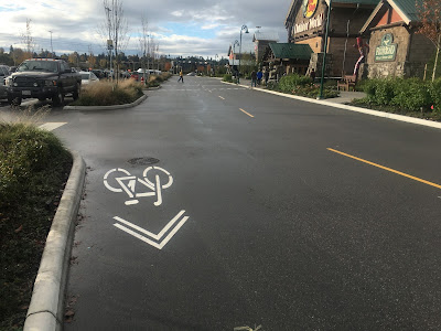
A bike sharrow on an internal road in Tsawwassen Mills. Select image to enlarge.

In fact, it looked like more bike parking was required at Tsawwassen Mills.

A bike locked to a light pole. Select image to enlarge.

A bike locked to a bench. Select image to enlarge.

Both the streets around Tsawwassen Mills and the mall itself used bioswales and pervious strips to manage stormwater in an environmental sensitive way.

Stormwater management at Tsawwassen Mills. Select image to enlarge.

Pervious strip in Tsawwassen Mills parking lot. Select image to enlarge.

So how does this apply to the City of Langley? Langley City has a large amount of high-density housing within a 10 minute walk of the Langley Bypass. Sadly, the Langley Bypass layout is actively hostel to people who walk or cycle to the area. People walk and cycle to businesses along the bypass in spite of this.

There is a lot of impervious asphalt around the Langley Bypass. Going forward, the City needs to seriously consider adopting the same stormwater management practices that are being used on TFN lands.

While the City of Langley has little control over the Langley Bypass right-of-way, we can work with land-owners to create safer cycling and walking access in the bypass area.

After walking around the Tsawwassen Mills area, it is apparent to me that providing safe walking and cycling access in auto-oriented areas is possible. It is also possible to reduce the amount of asphalt.

While pedestrian-oriented land-use is what I would prefer to see throughout all of the City of Langley, because the Ministry of Transportation manages the Langley Bypass right-of-way, this is next to impossible do to in that area. What was done in the Tsawwassen Mills area is likely the best way to provide safe walking and cycling access in auto-oriented areas.

Monday, October 24, 2016

Fall Council of Councils Meeting: Budgets, Housing, and Compass Card 2.0 was on the agenda

Metro Vancouver is a federation of local governments of which the City of Langley is a member. For more information on the services and governance that Metro Vancouver provides, check out an infographic I posted. Municipalities have some mayors and councillors that sit on various Metro Vancouver boards and subcommittees, but this is only a small subset of the total number of councillors in our region.

One of the ways that the regional district keeps all mayors and councillors up to date is by hosting biannual Council of Councils sessions. These sessions provide updates and facilitate dialogue on key regional initiatives.

On Saturday, I attended the fall Council of Councils session. The following is a brief summary of items discussed.

While the regional district uses the name Metro Vancouver, its legal names are the Greater Vancouver Regional District, Greater Vancouver Sewerage and Drainage District, and Greater Vancouver Water District. Because of the success of the Metro Vancouver brand, the regional district is now asking the province to replace “Greater Vancouver” with “Metro Vancouver” in the legal names of all the regional entities.

Metro Vancouver released its Regional Housing Strategy earlier this year. The federal government is currently working on a National Housing Strategy. Regional representatives and the federal housing minister have met several times about creating synergies between these strategies. With the support of the federal government, it is looking very promising that the Regional Housing Strategy many actually be able to move forward.

Last year, I posted about the Regional Propensity Initiative. Since that time, there have been several meetings on this initiative. It appears that it will be going full-steam ahead in 2017 and beyond.

Hearing a presentation on the proposed 2017 Metro Vancouver budget. Select image to enlarge.

Metro Vancouver is currently fine tuning its 2017 budget, you can read more about the budget on the Metro Vancouver website. The short of it is that the budget will be increasing by 5.6%. One of the largest drivers of this increase is the upgrading and expansion of sewer infrastructure in the region. If you have a $860,000 house, the budget increase will translate into around a $16 annual increase in the Metro Vancouver portion of your property tax bill.

Metro Vancouver’s regional growth strategy was adopted 5 years ago. Under provincial legislation, the regional district must see if there is a desire to have a comprehensive review of the strategy every 5 years. The regional district has been reaching out to local governments and other government organizations to see if there is a desire for a comprehensive review. Because the regional growth strategy is relatively new, early results appear to support some tweaking to the growth strategy, but no desire for a comprehensive review.

The regional growth strategy was designed as a living document, so it has been and continues to be refined. Some of the things that are being updated in the regional growth strategy include urban centre and frequent transit development area policies, and a review of how to support industrial businesses in the region.

Kevin Desmond who is the CEO of TransLink presented at the session. He went over the new proposed 10-Year Investment Plan for transportation in our region. Besides going over the 10-year plan, he also provided some insight into TransLink.

A good news story is that ridership is growing again. It was up about 2% last year, and is looking like it’s going up a further 2% this year. According to Desmond, the growth in ridership is happening faster than the rate of population growth. TransLink’s frequent transit network is seeing around a 5% increase in ridership.

Desmond noted that TransLink hasn’t done a good job of showing customers and residents in our region that it is listening to their concerns, and actually taking action from those concerns raised. He committed to doing a better job of engaging with people in our region.

He also noted several projects that TransLink is working on. This first project that he talked about was Compass Card 2.0. Some of the new features that are in the works for the system include business accounts, smart phone mobile ticketing, and the ability to use your credit/debit card to tap on/off transit.

They are also working on improving customer alerting, improving accessible transit service, and working on improving regional goods movement in collaboration with other stakeholders.

After hearing from Desmond at the session, we had a presentation about the upcoming Zero Waste Conference which will be taking place on November 3rd.

Thursday, October 20, 2016

Laminated Root Rot in Hunter Park requires significant tree removal

Map of City of Langley Parks in the south of the community. Hunter Park outlined. Select map to enlarge.

Hunter Park is located along 200th Street in the City of Langley. Earlier this year, City of Langley Parks staff became concerned that trees in this park were not healthy. After testing, it was determined that trees in this park have Laminated Root Rot. Here are some quick facts about the disease that was put together by the City:

Cross-section of trunk decay from Laminated Root Rot. Source: Dr R. L. James (www.forestryimages.org) (Hagle et al. 2003) USDA Forest Service.
  • Laminated Root Rot is considered to be the most damaging root disease in the Pacific Northwest.
  • Root systems of infected trees are so weakened structurally that the tree may topple before visible symptoms appear in the tree crown.
  • The disease spreads through root contact between adjacent infected trees or stumps and susceptible host trees such as Douglas Fire and Western Hemlock trees.
  • The Laminated Root Rot fungus may remain viable in stumps for up to 50 years. Susceptible tree species can be infected if planted or regenerated in the area.
  • Best management practices recommend that all known diseased trees as well as uninfected susceptible trees within 15 metres of an infected tree should be removed.

In Hunter Park, the City has identified that at least 100 trees will need to be removed. Because of the nature of this infectious disease, more trees may need to be removed if it has been found to have spread outside of the bounds of Hunter Park. Also, non-wind resistant trees may need to be removed within the park.

Unfortunately Douglas Fir, Grand Fir, and Hemlocks trees will not be able to be replanted in Hunter Park for 50 years. After the tree removals are complete, and the infectious disease contained, the City will be initiating a park redevelopment plan with community involvement.

One of the things that I’ve been advocating for is a tree canopy enhancement strategy. The time seems right for this to come forward, and I will continue to advocate for this. Logging trees in City parks is something that I wouldn’t normally support, but it is critically important to get Laminated Root Rot under control in our city to save the remaining Douglas Firs and Hemlocks.

For more information, please visit the City of Langley’s website.

Wednesday, October 19, 2016

October 17, 2016 Council Meeting Notes: RCMP third quarter report

Yesterday, I posted about the development matters that were addressed at Monday night’s council meeting. Today, I will be posting on the remaining items that were on the council agenda.

Ginger Sherlock, Langley Emergency Program Coordinator, gave a presentation about “The Great British Columbia Shake Out” which is a province-wide earthquake drill that will be taking place on October 20th at 10:20am. Sherlock pointed out that City of Langley staff will be participating in this drill.

Sherlock also noted that the Langley Emergency Program will be hosting a personal preparedness session on Tuesday, November 1st from 7pm to 9pm at the City of Langley Fire Hall. For more information, please email ep@langleycity.ca

After the presentation, Councillor Storteboom noted that there were no meetings of the Metro Vancouver Board or Climate Action Committee which is sits on, but did note that people should check out the Managing Rain on Residential Lots video that has been recently posted to the Metro Vancouver website.

Councillor Martin provided an update of the activities of the Fraser Valley Regional Library, highlighting upcoming events. An event that is interesting to me is a 3D printer demonstration which will be occurring at the City of Langley branch on Saturday, October 22nd.

The final report that council heard was from Superintendent Murray Power, OIC of the Langley RCMP detachment.

Langley City Year-Over-Year Crime Trends in 3rd quarter. Select table to enlarge.

Due to how policing is structured in BC, municipalities formal role in policing is essentially limited to just paying the bills. That being said in Langley, we have a very good relationship with the RCMP, and I believe a good line of communication.

Right now we get quarterly reports on crime statistics. While this is good, it really doesn’t give council the whole picture around policing in our community. Superintendent Power noted in his third quarter presentation on Monday that in 2017, we can expect a more fulsome report on policing in Langley City, including more detailed financial information. I’m really looking forward to seeing this improved reporting, and it is encouraging to see that the RCMP is voluntarily improving the lines of communications with local governments.

As I noted in a previous post, the largest number of calls to the RCMP were about issues resulting from homelessness.

Compared to the 5-year trend line, theft from auto is significantly up. Superintendent Power noted that people should be mindful of removing all personal items from vehicles to reduce this type of crime.

The RCMP stepped-up street checks in Langley City during the summer months with about half of all checks in Langley occurring in the City of Langley.

Business and residents break and enters year-to-date are below the 5-year trend line in the City of Langley. Year-to-date, there has been one homicide.

After the RCMP report, council gave final reading to Bylaw 3003 which is regarding permissive tax exemptions that I posted about previously.

Tuesday, October 18, 2016

October 17, 2016 Council Meeting Notes: Cascades Casino expansion approved as well as development variance permit

This is part one of two posts about last night’s City of Langley council meeting. This post will be about the development permit and development variance permit which council ended up approving.

Gateway Casinos & Entertainment, the owners of Cascades in the heart of Downtown Langley, had a development permit for a 23,056 sq ft expansion of their facility. The major components of the expansion include two new restaurants, expanded convention centre space which includes a new rooftop reception space, and an expansion to the gaming area. I should note that the amount of gaming equipment will not be expanding at this time.

According to Gateway Casinos & Entertainment, this project will result in about 100 new full-time jobs being created in Langley.

There are some issues with the current design of Cascades when it comes to the public realm. The facility is set back from Fraser Highway by about a block with surface parking between it and Fraser Highway. The current design of the casino also includes many blank wall. Altogether, this doesn’t create an engaging, pedestrian-friendly Fraser Highway along the frontage of Cascades.

There are several things in this development proposal that will enhance the public realm, and hopefully set the stage for future expansion. The expansion of the facility will see the replacement of blank walls as shown in the following renderings.

Cascades Casino expansion renderings. Select image to enlarge.

This is a vast improvement over the current design. Also good is that some of the surface parking fronting the facility is being replaced to accommodate this expansion. A new landscaped sidewalk will front the expanded facility.

Site and landscaping plan for Cascades Casino expansion. Select image to enlarge.

One of the remaining challenges is that even with the expansion, Cascades is still setback from Fraser Highway. Right now, there is a pedestrian connection at 56th Avenue/Fraser Highway to the west entrance of the casino. The sidewalk is narrow, has no pedestrian scale lighting, and has limited landscaping.

Eventually, I hope that Gateway Casinos & Entertainment will be able to expand their site to have one or more buildings front Fraser Highway that will create an active and engaging public realm. As an interim step, I asked the architect at the meeting if he would consider improving that 56th Avenue/Fraser Highway pedestrian connection to create a more prominent pedestrian-friendly entrance from Fraser Highway. This would enhance the public realm along Fraser Highway, encourage people walking along Fraser Highway to visit Cascades, and provide a cue for people visiting Cascades to explore Downtown Langley. I believe this would be a real win-win.

The architect supported this idea. Later during the meeting when council was voting on whether to approve this development application, I asked our Director of Development Services if we needed to amend the development permit application to include wording to ensure that this enhanced pedestrian access would be built. I was told that we didn’t, and that the City will be working with Gateway Casinos & Entertainment to make this happen.

As part of the expansion of this facility, Gateway Casinos & Entertainment will also be upgrading the streetscape along the sections of Fraser Highway and Glover Road which front their property. This will most certainly enhance the public realm.

The combination of the new expansion, streetscape improvements, and enhanced pedestrian connection between Fraser Highway and Cascades will be a welcomed addition to Downtown Langley.

An example of the scale of the new houses as part of the subdivision of 20508 46A Avenue. Select image to enlarge.

As I noted earlier, council approved a development variance application for the subdivision of 20508 46A Avenue. The front width of the lot was varied from 16m as required in our RS-1 zoning to 15.4m. The proponent of this application received the support of his neighbours, and the proposed houses appeared to fit within the character of the neighbourhood which is why I supported the variance.

Tomorrow, I will post about the other items discussed at Monday night’s council meeting.

Monday, October 17, 2016

Tsawwassen Mills and Tsawwassen Commons: The Best Laid Plans

Tsawwassen Mills recently opened in our region. The retail space of this mall is slightly smaller than Guildford Town Centre. Tsawwassen Mills uses more land because it is not multi-story and doesn’t have structured parking like Guildford Town Centre. It also has about 1,000 more parking spaces (6,000 in total) than Guildford Town Centre.

Tsawwassen Commons, a power centre that would feel right at home along the Langley Bypass, will be opening up just north of Tsawwassen Mills shortly.

An artist's drawing of the actual land use of the "mixed-use" area of TFN lands. Select image to enlarge.

Most of the malls in our region were developed on former agricultural land. In Langley City, it was no different. Our power centres and Willowbrook Mall were farmland at one point. When looking at projects like Tsawwassen Mills and Tsawwassen Commons, it is the rapid and massive conversion of farmland to auto-oriented retail that has caused alarm for people. Rapid urbanization of farmland was one of the reasons why the Agricultural Land Reserve was created it in the first place.

Tsawwassen First Nations (TFN) has a land-use plan. It is really interesting to see the original plan for the lands that are now the location of Tsawwassen Mills and Tsawwassen Commons.

TFN Land Use Map. Select map to enlarge.

Under the TFN plan, Tsawwassen Mills and Tsawwassen Commons are in a mixed-use area. According to the land-use plan, this area can include “hotel, retail and business park uses. A mixed use community is planned with single family, town home and apartment style housing”.

This area was to be connected to the surround agricultural lands “through a series of green fingers and blue ways that will penetrate throughout the development. A new stream will link the storm retention ponds and irrigation canals creating an attractive water feature. The streets will be tree lined and contain safe pedestrian and bicycle lanes.”

The plan always included the provision for a “a premium outlet or similar specialty retail mall adjacent to Highway 17.” On the land use plan, this is noted a “specialty retail.”

Now this land use plan likely would have taken decades to fully build out. A project like Tsawwassen Mills took less time to build, meaning it would be delivering economic benefit to the TFN almost immediately. Even in Langley City, development projects have been approved that are questionably in the spirit of our official community plan. Many people believe that having something is better than a brownfield or vacant site.

I’m not a fan of auto-orient retail, but I can certainly see why TFN made the decision they did. This is why having a regional growth strategy and the ALR is so important. It creates a tension which balances the social, economic, and environmental priorities of our region as a whole.

Thursday, October 13, 2016

Last night’s forum on homelessness, and action the City must take in the next six months

Last night at the Cascades Casino Convention Centre around 250 people attended a forum on homelessness within the City of Langley. The forum was put together by the Hon. Mary Polak who is the MLA for Langley City. Panellist included Mary Polak, John Aldag MP for Langley City-Cloverdale, City of Langley Mayor Ted Schaffer, and Officer in Charge of the Langley detachment of the RCMP, Superintendent Murray Power. The forum was moderated by Teri James who is the Executive Director of the Downtown Langley Business Association.

A packed house at last night's forum on homelessness within the City of Langley

The Langley Times has publish an article which provides an account of what happened at the forum, but I also wanted to post in board strokes what I heard from people and panellists at the forum, and the next steps that I think the City of Langley could take to move forward with reducing homelessness in our community.

At the forum, I was pleased to see and hear that the majority of people in attendance were looking for solutions.

People who live next to places where people experiencing homelessness camp spoke at the forum about the challenges they face living next to these camps. These people's quality of life has been reduced.

People who have experienced homelessness, living in parks and on the street in Langley City, spoke at the forum about the challenges they face daily. One person said that they want help, but the kind of help required wasn’t readily available.

It is clear to me that the current situation in Langley City is failing both our housed and homeless residents.

People at the forum also noted that youth in Langley are experiencing homelessness, but the support systems for these young people are less available than for adult, or are completely non-existent in our community.

There appeared to be consensus at the forum that government needs to step up to ensure that people have low-barrier access to mental health care and addiction treatment services. There was also a call to make sure that there was the right amount of housing options available for all people of all ages in our community, no matter where they are at including: shelter space, supportive housing, transitional housing, and affordable housing.

I believe that people know what needs to be done, and they are looking to government to get the job done. The BC Liberals have made housing a key part of their upcoming election campaign, and are looking to show leadership. Mary Polak stated that the province is looking to do something in Langley around housing. The federal Liberals are working on their National Housing Strategy, and John Aldag stated that he will work to get federal funding for supportive/affordable housing in Langley City. The role of the City of Langley is to show leadership, and work with both the federal and provincial governments to ensure our residents get the support they need.

Based on what I've heard over the past several months from people, I believe the City of Langley should be doing the following over the next six months:

  • Strongly advocate for the provincial government to make the temporarily funded shelter spaces in our community permanently funded.
  • Strongly advocate for the provincial government to provide funding for a youth shelter within Langley.
  • Strongly advocate for the provincial and federal governments to fund, and work with the provincial government to find a suitable location within the Langley Urban Centre, for a supportive housing facility with 24/7 wrap-around support service to stabilize people who have been homeless with the goal of transitioning them into permanent housing.
  • Strongly advocate for Fraser Health to provide an Assertive Community Treatment team for Langley.
  • Work with the province to ensure that all people in Langley City have access to low-barrier mental health care, and addiction treatment services.
  • Ban camping within the Nicomekl Floodplain due to safety risks and the environmental sensitively of the area (camping cannot be banned in all public parks due to a recent court ruling.)
Map of Langley Urban Centre (in red). Select map to enlarge.

I will continue to work with others on council to ensure that we are doing our part to reduce the number of people camping in our parks and living on our streets, getting them into supportive housing.

Wednesday, October 12, 2016

Hearing from the community: Langley City neighbourhood meetings

This month, the City of Langley is hosting three public meetings throughout the community. These meetings are an opportunity to see what the City has been working on, ask questions, and provide feedback.

The City did have a few questions that we wanted to get feedback on: What in the City of Langley creates a sense of pride and why? What do you think should be a priority for the City over the next 5 years? Would you support an infrastructure levy?

F
From last night's meeting. What would you be willing to pay to keep our infrastructure in a state of good repair? Select image to enlarge.

So far there have been two meeting, last week there was a meeting at Nicomekl Elementary School and last night there was a meeting at HD Stafford.

The meetings started with the mayor giving a mini-state of the union. Afterwards, people went to one of the many booths staffed by members of various City departments or the RCMP. Members of council were also wondering around, answering some questions and hearing from residents.

So far around 200 people have attended the public meetings, and I’ve personally had some really good conversations with people who live in the community.

Addressing homelessness has certainly been on the top of the priority list for the City of Langley over the past several years. Over the past month, with the help of BC Housing and the Salvation Army, we have been able to get people out of our parks and into shelter spaces. There is still much work to be done. At the meeting, addressing homelessness was certainly a topic that came up, but it wasn’t the topic I heard about the most from residents.

From the feedback I heard at the public meetings so far, people love Langley City because of its parks system, walkability, downtown, public events, and community spirit. The people I talked to at the meetings wanted more investment in our community infrastructure, and to bring more positive activities into our downtown core. Several people talked to me about wanting to see more mixed-use buildings in downtown (businesses on the bottom with residents on the upper floors.)

When it came to investing in infrastructure, people were very supportive. Who wants their community to crumble apart? I heard loud and clear that people were willing to invest as long as they knew where the money was going. I’m in full support of an infrastructure fund that is dedicated to replacing aging roads, water, and sewers lines.

As for roads, I also heard loud and clear that people want better sidewalks, bike lanes, and traffic calming. In our parks, people commented that they want more investment in our trail system. This again is something that I fully support.

The 203rd Street project is an example of a road that will be traffic calmed with improved sidewalks and protected cycling lanes. If this project is successful, I would certainly be interested in doing the same thing along Grade Crescent and along 53rd Avenue.

Our parks department is now focusing on basic maintenance of our parks system. For example over the next little while, the City will be installing new wayfinding signs to help people better navigate our extensive trail system.

I had one person approach me about the proposed rainbow crosswalk in Fort Langley, expressing concern about the cost. I let them know that this is a Township of Langley matter.

The City will be holding one more neighbourhood meeting as follows:
Date: October 19, 2016
Time: 6:00pm – 8:00pm
Location: Alice Brown Elementary School Gym, 20011 44 Avenue, Langley

Tuesday, October 11, 2016

Proposed design for new Pattullo Bridge released. Will more truck traffic be going thru New West?

What to do with the Pattullo Bridge has been on the agenda of TransLink for some time. The bridge has major structural issues, and TransLink is currently doing repair work to prevent the bridge from literally crumbling into the Fraser River within the next decade.

TransLink, Surrey, and New Westminster worked through a design process back in 2013 that looked at all sorts of options for replacing the Pattullo Bridge including the size and location. While most of the details were worked out, the City of Surrey wanted to see a six-lane bridge while New Westminster wanted nothing more than four-lanes.

For the Mayors’ Council Regional Transportation Investments Plan which people voted on in 2015, the region agreed that the Pattullo Bridge would be tolled, four-lanes, and could be expanded to six-lanes in the future.

Example cross-section of new Pattullo Bridge with four-lane to six-lane option. Select image to enlarge.

Because the current Pattullo Bridge has serious structural issues, TransLink has still been working towards getting the bridge replaced as soon as possible. This month, TransLink is seeking feedback on the proposed design for the new bridge.

Artist rendering of proposed Pattullo Bridge. Select image to enlarge.

Besides improving safety for people driving over the bridge, cycling and walking infrastructure will be improved.

The following proposed design shows how TransLink is looking a connecting the new Pattullo Bridge to the road network in Surrey which includes a grade-separated interchange.

Proposed connections between Pattullo Bridge and Surrey transportation network. Select image to enlarge.

On the New Westminster side of the bridge, the following connections are being proposed.

Proposed connections between Pattullo Bridge and New Westminster transportation network. Select image to enlarge.

One of the new changes to bridge connectivity is improved access to East Columbia Street. This is likely to improve truck access from that road over to Surrey, and could support a future North Fraser Perimeter Road. An off-ramp from the bridge onto the southbound lane of the South Fraser Perimeter Road plus a proposed Scott Road Extension which will connect to the northbound lane of the South Fraser Perimeter Road will enable this access.

There is a series of meetings that will be held this month, plus online feedback is also being accepted on the proposed access to the bridge. For more information, please visit TransLink’s website.

Thursday, October 6, 2016

Value for Service - Property Tax in Langley City vs. Strata Fees, and the rest of the region.

No one likes paying bill. I don’t get much pleasure from paying my phone, Internet, or electric bill. Paying my mortgage or strata fees doesn’t put a smile on my face. I pay the bills because I do value having a roof over my head, lights, heating, hot water, and fast Internet access.

One of the things that I’m sure most people aren’t super thrilled about is getting their City of Langley property tax bill. The average household in Langley City pays around $2,000 per year in property tax and user fees to the City. Compared to the rest of the region, we have the lowest property tax and fees in the region on average. The following chart is from my friend Patrick Johnstone who is a Councillor in New Westminster.

Total residential taxes and user fees collected by Municipality per Household (BC Gov’t and Metro Vancouver data)

Langley City’s portion of property tax and fees pay for local roads, police protection, fire protection, community centres, public events, libraries, water service, sewer service, recycling, garbage collection, local parks, and planning services. It’s an overall great value.

I pay about $3,000 per year in strata fees, and I’m told I live in a building with low strata fees. What do I get for $3,000 per year? The building gets maintained, the lawn get mowed, and I get hot water. I get way more services from the City of Langley for less money paid!

So why am I bring all this up? One of the things that I’ve heard from residents in Langley City loud and clear is that we need to invest more in our infrastructure and in our community to maintain quality of life. Unfortunately, there are also some areas were the City has chronically under-invested in over the years. To get us on the right path will require a modest increase in property tax over and above regular inflationary pressures.

Later this year and into early next year, Council will be finalizing the 2017 budget. I will be doing my best to ensure that we are investing in our community because maintaining the quality of life, services, and infrastructure for people that call Langley City home is something that I believe is critically important.

Wednesday, October 5, 2016

October 3, 2016 Council Meeting Notes: More redevelopment, a road closure, and engineering updates

As I posted about yesterday, there was a public hearing on Monday regarding two rezoning applications. I posted about the rezoning to support a townhouse development along 55A Avenue already. The other application was for an apartment building along 53A Avenue near 201A Street.

This development was previously approved by council several years ago, but due to the economic conditions at the time, the project did not go ahead. Some of the changes to the development include the addition of secure bike parking and electric vehicle charging stations. This is really good to see as the project is right next to the future 203 Street protected cycleway. Also, the secure electric vehicle charging may help lower the barrier to EV usage.

Elevations of proposed apartment near 53A Avenue and 201A Avenue. Select image to enlarge.

There were two people that had concerns about the development. One was concerned if the lane was designed properly. City staff noted that it was. Another person was concerned about the loss of private.

Site plan of proposed apartment near 53A Avenue and 201A Avenue. Select image to enlarge.

While not related to the rezoning application, another person was concerned about construction noise and vibrations. Our bylaw officers have been busy addressing the impacts of homelessness over the last little while, and it seems like bylaw enforcement resources might be stretched a bit too thin to address all bylaw enforcement matters.

Later on during the regular council meeting, the rezoning application was given third reading with Councillor van den Broek opposed.

After the public hearing, there was a Committee of the Whole to allow people to comment on the 2015-24 Financial Plan amendment to support capital road work, improved sewer service, the new Timms Community Centre, and a new fire pumper truck. There was no comments from the public, and this amendment was approved later on during the regular council meeting.

Council gave third reading to approve the start of the process of closing a road behind 20797 Langley Bypass. The road right-of-way hasn’t been used as a road since I’ve been around.

Proposed section of unused road to be closed near the Langley Bypass and Glover Road. Select image to enlarge.

Council received various updates at Monday’s council meeting, and I wanted to highlight the engineering update which was presented by Director of Engineering, Parks and Environment Rick Bomhof.

The City recently received grants from both the provincial and federal governments. $10,000 will be used by the City to complete a new Water & Sewer Master Plan.

The City also received $2.9 million to support the replacement of water and sewer lines under 56 Avenue between the Langley Bypass and Glover Road. The federal government contributed 50% while the province contributed 33%.

Bomhof noted that the 203 Street project is going well, and it is expected that the section north of 53 Avenue will be open before Christmas. The remainder of the road should be open by February.

Traffic calming is also in the works near Simonds Elementary School along 48 Avenue, and along 50 Avenue near Conder Park. A section of water main near 51 Avenue and 208 Street was also replaced.

Finally, new game equipment was installed in Douglas Park, and the bridge in City Park near the pool was replaced.

Tuesday, October 4, 2016

October 3, 2016 Council Meeting Notes: Redevelopment and new lane concern some residents

This week’s City of Langley council meeting notes will be in two parts. Today, I will be posting about the proposed rezoning of 19660, 19674, and 19680 55A Avenue to accommodate a 19 unit townhouse development. This area is designated medium density in the Official Community Plan, and has been for over two decades.

View of proposed 19 unit townhouse development from 55 A Avenue. Select image to enlarge.

This is a former single-family housing area which is transitioning to a higher density. To the south of the property being rezoned is an older, gated single-story townhouse development called Huntsfield Green that was built in the early 1990s. It is also medium density.

Location of rezoning application. Select image to enlarge.

About 40 residents from Huntsfield Green were at the public hearing to express their opposition to the rezoning. Some of the reasons for the opposition included:

  • Not knowing the area was zoned medium density.
  • Concerns about the increase in traffic noise in the lane on the north side of Huntsfield Green due to the new townhouse development.
  • Concerns that the retaining wall and new fencing on the north side of Huntsfield Green to support the lane will not be technically sound.
  • Concerns about the loss of privacy as the new townhouse units are three-storeys.

The residents from Huntsfield Green that attended the public hearing did not want to see the lane constructed, but instead wanted to have vehicle access to the proposed townhouse development via the street. The City's development guidelines state that whenever a lane is available, vehicle access should be provided via the lane.

Site plan of proposed 19 unit townhouse development. Select image to enlarge.

There are some good reasons for providing vehicle access via lanes including enhanced safety for walking and cycling, and the creation of a more livable street. There is a good technical bulletin from the UBC School of Architecture + Landscape Architecture which outlines the benefits of this type of design.

Interesting enough, the lane actually provides separation between the 19 unit townhouse development and Huntsfield Green which wouldn’t exist if access was provided via the main street.

One of the questions I asked the proponent of the development was what they were doing to ensure the privacy of both Huntsfield Green and residents of their project. The patios in the development will be oriented away from Huntsfield Green, and trees will be planted to further enhance privacy.

As far as the concern about the construction of the retaining wall, there are professional standards that must be met.

It is unfortunate that some residents didn’t know that they were in a medium density area. One of the things that I’d like to see completed is a comprehensive update of our Official Community Plan. The accompanying public engagement would be an opportunity for people to develop a renewed vision for the community, and would certainly increase awareness around lane-use.

There were also concerns expressed by other residents that the lane won't be able handle the traffic, service vehicles, or emergency vehicles as a result of this proposed development. City staff noted that the lane is designed to accommodate current and future traffic levels, plus all service and emergency vehicles.

There were a few other residents in the area that came out to the public hearing to express their concerns of people parking in areas where they shouldn’t, and also about speeding traffic along 198 Street. While not related to the development, the City needs to investigate possible traffic calming and parking enforcement in the area.

At the end of the day, the rezoning application was consistent with our Official Community Plan, zoning, and development guidelines. It was given third reading with Councillor van den Broek opposed.

Monday, October 3, 2016

Reducing sexual violence at UBCM and on transit

Last week at the Union of British Columbia Municipalities Conference, I talked with several colleagues —both male and female— about the pervasiveness of Rape Culture in our province. Rape Culture blames victims of sexual assault and normalizes male sexual violence. Women Against Violence Against Women is a good resource for more information on this disturbing topic.

Even at the UBCM conference, which should be a safe space, Rape Culture is ever-present. I heard stories first-hand from victims of sexual violence at the conference. Because of the pervasiveness of sexual violence, a resolution was approved at this year’s conference asking for a code of conduct for UBCM events. The resolution called for the creation of a safe mechanism for people to report sexual harassment.

If people don’t feel safe reporting sexual violence at a conference for elected officials such as UBCM, it is no surprise that people are not reporting sexual violence that occurs on public transit.

TransLink’s Transit Police started to take sexual offences more seriously in 2014. As a result, the number of reported sexual offences rapidly increased year-over-year.

Transit Police sexual offence reports from 2011 to 2015.

While it might appear that more sexual offences are occurring, it actually means that more people are reporting sexual offences which is the first step to reducing sexual offences.

The authors of the Transit Police 2015 Report to the Community state that “in 2015 more than 60% of those suspects identified had not previously come to the notice of police. Research suggests that those who commit more serious sexual offences escalate their behaviours after starting their offending history with inappropriate touching or similar offences. The early identification of this type of offence provides an opportunity to intervene and prevent such escalation.”

One of the ways that the police service is trying to make reporting sexual offences safer is with the “promotion of the transit user friendly ‘On Duty’ App and Transit Police 87 77 77 SMS/Text line both of which provide the opportunity to discreetly report offending or suspicious behaviours.”

Reducing sexual violence against women and not shaming victims of sexual violence should be a priority for all public organizations. It is disturbing that some people don’t even believe this is a serious problem today. It is good that some public organizations are starting to address reducing sexual violence in public spaces.