Thursday, October 31, 2019

Changes in commuting over the last 20 years in Metro Vancouver. Neighbourhoods that generate congestion, neighbourhoods that don't.

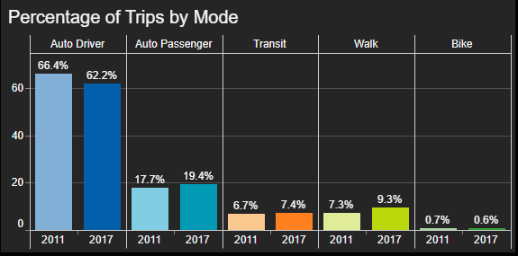
Jens von Bergmann runs the Mountain Doodles blog where he shares data visualizations and insights based on Statistics Canada data. I’ve previous shared some of the visualizations that he has created in the past. His latest visualizations look at how people commute to work in Metro Vancouver based on neighbourhood-level census data.

One of the interesting visualizations is the change in the number of people driving to work between 1996 and 2016 which is the most recent census.

Change in number of drivers 1996 – 2016. Select image to enlarge. Source: MountainMath, Statistics Canada

The purple areas show where there has been a larger increase in the number of people driving to work, while the yellow areas show where there has been a decrease in the number of people driving to work.

In Langley City, we can see that in some neighbourhoods there has been no or a reduction in people driving to work in absolute numbers. In other Langley City neighbourhoods, there has been modest growth such as in the 198 Street/Brydon area over the last 20+ years.

Clayton in Surrey, and Willoughby in the Township of Langley, have seen a large increase in people driving to work over the same time period. This makes sense as these are new communities.

Another interesting map shows the net difference between driving and non-driving as the method of commuting to work over the last 20+ years.

Difference in change in number of non-drivers vs drivers 1996 – 2016. Select image to enlarge. Source: MountainMath, Statistics Canada

This is useful as it can show which neighbourhoods are more auto-dependent, even accounting for population growth and changes in the number of people that must commute to work.

Again, Langley City has neighbourhoods that range from transit-friendly to more auto-dependent. The most auto-dependent neighbourhoods near Langley City are Clayton and Willoughby.

There are two reasons for neighbourhoods being more auto dependent. One is a lack of transit service, and the other is urban design that doesn’t encourage walking. Most transit riders start their commute by walking.

The next census will be in 2021, so it will be interesting to see how things have changed. There is much more information Jens’ Commuter Growth post.

Wednesday, October 30, 2019

Tips to make sure your vehicle is not a target for “prolific offenders”

I currently chair Langley City’s Crime Prevention Task Group. One of the major goals of the task group is to provide education to both residents and business owners in our community about how they can help reduce the types of crime we see in our community. While Langley City is a safe community, we have a large amount of people stealing items from vehicles, and stealing vehicles. The people committing these crimes are a small number of what the RCMP calls “prolific offenders.”

While the RCMP works to catch these “prolific offenders”, they also provided our task group with a winter safety sense guide to share with others. This guide provides tips on how to help reduce these kinds of crime.

Below is some excerpts from the guide.

When parking your vehicle:

  • Never leave a wallet or purse in your vehicle
  • Look around your vehicle and see what items you’ve left in plain sight. Things that don’t appear temping to you, could be attractive to a thief. Items can include clothing, food, and loose change.
  • Report any suspicious activity around vehicles to the RCMP
  • Chose well-lit areas to park your vehicle. Park if possible in areas near high foot traffic.
  • Always close windows and lock doors
  • Use an anti-theft device
  • Keep your spare keys in your wallet, not in your car

When shopping:

  • See if a shop or mall has lockers to store purchases until you are finished shopping
  • Do not lock your purchases in your vehicle or in your vehicle’s trunk. Thieves often target parking lots watching for people to place items in their vehicle, and then leave their vehicle unattended.

At home:

  • Light your driveway all night
  • After opening your garage door or strata parking gate, watch out for thieves waiting to slip inside. Wait for the door or gate to close behind you.
  • If you see any suspicious activity around your parking area, call the RCMP

The Non-Emergency Line for the Langley RCMP is 604-532-3200.

Tuesday, October 29, 2019

Slicing and Dicing the Numbers: 2019 Municipal Property Tax in Metro Vancouver

The provincial government collects taxation information from municipalities, and provides this information online. They have recently posted this information for 2019 online. To help visualize this information, and provide some context, I’ve created some tables and charts.

The first chart looks at the per capita property tax in 2019. I used the information from the province’s Schedule 703, and combined that with 2018 population estimates. I’ve highlight Langley City for convenience.

2019 Property Tax Per Capita in Metro Vancouver by Municipality. Select chart to enlarge.

One of the things that stands out is that Surrey has a significantly lower per capita property tax. One of the things to consider is household size. For example, Surrey has an average household size of 3 while Langley City has an average household size of 2.1.

Municipality Population Total Property Tax Collected Per Capita Property Tax
Surrey 569,065 $364,429,422.12 $640.40
Anmore 2,389 $2,210,793.40 $925.41
Maple Ridge 88,626 $84,644,022.90 $955.07
Coquitlam 149,490 $151,087,559.85 $1,010.69
Langley City 27,577 $29,069,351.98 $1,054.12
Port Coquitlam 62,844 $66,549,258.31 $1,058.96
Richmond 216,300 $231,099,685.35 $1,068.42
Belcarra 684 $734,048.79 $1,073.17
White Rock 21,370 $23,163,637.99 $1,083.93
Langley Township 127,290 $138,325,635.12 $1,086.70
New Westminster 76,799 $83,939,035.07 $1,092.97
Burnaby 248,476 $273,684,820.07 $1,101.45
Pitt Meadows 19,772 $22,689,385.92 $1,147.55
District of North Vancouver 90,814 $104,615,821.97 $1,151.98
City of North Vancouver 56,741 $65,831,476.42 $1,160.21
Lions Bay 1,407 $1,634,595.33 $1,161.76
Vancouver 672,963 $823,944,278.13 $1,224.35
Port Moody 35,613 $45,406,517.80 $1,275.00
Delta 109,484 $144,196,476.30 $1,317.06
Bowen Island 3,977 $5,379,364.22 $1,352.62
West Vancouver 44,886 $73,837,205.17 $1,644.99

Another way to look at property tax is by a representative household. This is known as the province’s Schedule 704.

Property Tax on a Representative House in Metro Vancouver by Municipality. Select chart to enlarge.

Again, Langley City has been highlighted for convenience.

Municipality Property Tax on a Representative House
Belcarra $1,673
Surrey $2,028
Langley City $2,081
Pitt Meadows $2,110
Langley Township $2,126
Port Coquitlam $2,339
Burnaby $2,409
Maple Ridge $2,417
Bowen Island $2,426
Delta $2,449
Coquitlam $2,580
Richmond $2,592
City of North Vancouver $2,742
Anmore $2,838
Distrcit of North Vancouver $2,915
Lions Bay $2,923
New Westminster $2,949
Vancouver $3,059
Port Moody $3,346
White Rock $3,479
West Vancouver $4,802

Property tax bills also have charges that are set by the province, Metro Vancouver Regional District, and TransLink. There are also user fees for water, sewer, and solid waste. The proceeding tables only look at property tax set by municipalities.

Monday, October 28, 2019

Fall Regional Council of Councils: Water, Sewer, Parks, and Affordable Housing Updates

Two times per year, the Metro Vancouver Regional District hosts a Council of Councils meeting. This meeting is an opportunity for all 156 elected local government representatives in Metro Vancouver to receive updates from and ask questions directly to the regional district. Municipalities in our region appoint people to sit on the Metro Vancouver Board which is where regional decisions are made. Currently, there are 40 people on the Metro Vancouver Board.

On Saturday morning, all members of Langley City council attended the Council of Councils meeting.

Some of the topics covered are summarized below.

Strategic Plan

The regional district has updated its strategic plan based on a 30-year financial outlook. This plan guides the actions of the regional district. The plan focuses on strengthening the regional federation of local governments, continuing to delivery core services (water, sewer, solid waste, affordable housing, and parks), and improving regional planning.

35,000 people moving to our region every year, plus the impacts of climate change, mean that serious investment is needed to ensure that clean drinking water is available for everyone, wastewater is properly treated, and that our natural environment continues to thrive.

More Information: http://www.metrovancouver.org/about/strategic-directions/Pages/default.aspx

5-Year Budget Outlook

Metro Vancouver Regional District services are funded directly by property tax except for water and sewer services. Water and sewer services are purchased by member municipalities who are charged a rate based on consumption. In Langley City, we use water meters to pass this charge onto property owners based on individual consumption. The City also adds the cost to maintain the local distribution system which connects individual properties to the Metro Vancouver water main. This is charged based on a flat fee plus consumption.

5-year outlook, regional operation expenditures. Select chart to enlarge.

5-year outlook, regional capital expenditures. Select chart to enlarge.

Regional water and sewer services are by far the largest regional expenditures. These costs will be increasing over the next 5 years due to the massive investment needed to adapt to the impacts of climate change, keep the system in a state of good repair, and to accommodate population growth.

One of the big projects in Langley is the $537.6 million expansion of the Northwest Langley Wastewater Treatment Plant.

More Information: http://www.metrovancouver.org/services/financial-services/programs-budget/BudgetPublications/MV2019-2023-5-YearOutlook.pdf

Regional Parks

Parkland acquisition is a priority as we need to protect the remaining green space that is currently undeveloped in our region. The 2020 regional budget proposes $7.6 million per year going forward to make this happen. The goal is to protect an additional 10% of the land in our region.

40% of the land in our region is protected from development. 10% of the land is unprotected and undeveloped. Select chart to view.

More information: http://www.metrovancouver.org/services/parks/ParksPublications/RegionalParksLandAcquisition2050.pdf

Metro Vancouver Housing

The regional district is the second largest affordable housing provider after BC Housing in Metro Vancouver. 9,400 tenants living in Metro Vancouver Regional District Housing. There is an affordable housing crisis in our region.

To help respond to this crisis, the regional district is upping its housing budget by $4 million per year to build at least 500 new units of affordable housing. We were told at the meeting that this number could grow to 1,500 new units with partnerships likely to come from the feds and province.

Air Quality and Climate Change

Metro Vancouver is responsible for regulating air quality from stationary emitters such as factories, plus off-road vehicle emissions such as construction equipment. The regional district also provides statistics and advice to municipalities to reduce emissions and mitigate the impacts of climate change.

More information: http://www.metrovancouver.org/climate2050

Thursday, October 24, 2019

Congestion increasing delays and decreasing reliability of bus service. RapidBus program to reverse negative trend.

If there is one thing that is certain, it is that the population will continue to increase in Metro Vancouver. With increased population can come increased congestion on major roads, but this is not always the case.

One of the only ways to give people a way out of congestion is to make walking, cycling, and taking public transit safe, fast, and inviting.

In places like New Westminster, road congestion hasn’t increased because of the investment in high-quality walking infrastructure and transit service in that community.

The South of Fraser, and other parts of Metro Vancouver, doesn’t have this same level of higher-quality transit service which is causing road congestion to increase. This means that the time it takes to get places whether by bus or by car is increasing. TransLink found that around 80% of bus routes are slower today than they were five years ago. With over 60% of all transit ridership in our region from bus service, this is a serious issue.

This slowdown in bus routes is bad news not only because it now takes people more time to get to where they need to go, but it also requires TransLink to provision more buses due to congestion, leaving less buses available to expand the transit network. In fact, congestion costs TransLink over $75 million per year to maintain bus service reliability.

TransLink recently released a map of the bus corridors that are the most impacted by congestion. The Fraser Highway corridor is on this map.

Top 20 most congested corridors that are delaying people riding buses in Metro Vancouver. Select map to enlarge.

So how do you get buses moving to reduce congestion? Through TransLink’s RapidBus program, in partnership with municipalities, bus priority measures are being introduced throughout the region. The best way to get buses out of congestion is to introduce bus-only lanes and reconfigure intersections and traffic lights to prioritize buses. Some earlier work shows that this worked, including along King George Boulevard.

In Langley City, we will be changing current general travel lanes to restricted bus lanes along some sections of road in our downtown to help speed up bus service. While it may seem that switching general travel lanes to bus lanes would further increase congestion, it does the opposite.

Fast and reliable bus service actually causes people to stop driving and start taking transit. A good case study would be the Broadway corridor in the City of Vancouver.

The RapidBus program will be successful if municipalities continue to partner with TransLink to build out bus lanes and intersection improvements to keep transit service running on-time. This will give people a way out of congestion, and keep our economy moving.

Wednesday, October 23, 2019

October 21 Council Meeting: Langley Community Hub, Fire Ops 101, and Cultural Connections Gallery

Sharing a healthy meal with friends or family is something that many of us take for granted, but for some people in our community this isn’t possible. Some people may not have the skills or tools to plan and prepare a healthy meal, some people may not have the finances, and some people could be disconnected and isolated from others for various reasons.

The Langley Healthier Community Partnership brings together our two municipalities, health care providers, and non-profit organizations to help improve the health of people in Langley. One of the initiatives of this group is to investigate a Community Hub.

The following video was shared at Monday night’s Langley City council meeting about what a Community Hub is.

Right now, the Langley Healthier Community Partnership is exploring what it would take to get a Community Hub going, including finding a potential central location that is accessible and includes an outdoor garden, commercial kitchen, and the opportunity for social enterprise.

IAFF Firefighters held a Fire Ops 101 programs which occurred during the most recent Union of BC Municipalities Convention. Councillor Albrecht took part in this program, and was recognized for his participation on Monday night by Langley City Firefighters Local 3253.

Councillor Albrecht being presented with a commemorative fire helmet for participating in Fire Ops 101. Select image to enlarge.

Fire Ops 101 is designed to give elected representatives and senior local government staff members a small sample of what it is like to be a firefighter, including putting out a fire and performing a rescue.

A slide about the Cultural Connections Gallery. Select image to enlarge.

Currently at Langley City Hall, there is the “Cultural Connections Gallery.” This exhibit which is on display until November 28th explores “first steps, first impressions, and first experiences” of newcomers to Canada.

Tuesday, October 22, 2019

October 21 Council Meeting: $0.75 million investment into Brydon Park. Developing ridesharing regulations

Last night was the 43rd Canadian general election, and it was also a regular Langley City council meeting.

Recently, the provincial government enabled the framework to allow ridesharing companies to operate throughout British Columbia. While the regulation of these services is mostly a provincial responsibility, the following items are the responsibility of municipalities in regards to ridesharing:

  • Issuing business licences and setting business licence requirements
  • Regulating through street and traffic bylaws

Some examples of the types of things municipalities can regulate include passenger loading zones, and the age and types of vehicles used for ridesharing.

Council passed the following motion to ensure that we get regulations in place:

THAT staff be directed to provide a report regarding developing a ridesharing and ride hailing policy, appropriate regulations, and supportive business licensing frameworks, working with TransLink, Metro Vancouver, and other municipalities.

Before passing the motion, Councillor Albrecht noted the importance of making sure that ridesharing fleets are accessible for all people in our community. I noted that ridesharing can come with negative externalities such as increased congestion, reduced transit usage, and challenges with passenger loading. I stated that we should be considerate of these externalities when developing our policies, licensing, and regulations.

San Francisco is the heart of the ridesharing industry, and that city is taking measures to ensure that their streets are usable for all users, reducing some of the negative impacts of ridesharing. For more information, check out Better Market Street.

Council also gave final reading to the 2020 Permissive Tax Exemption Bylaw. For more information about this bylaw, please read a previous post on the topic.

As I posted about earlier, work is underway to improve Brydon Park which is in one of the fastest growing neighbourhoods in Langley City.

Brydon Park - Phase 1 Renewal Concept Plan. Select image to enlarge.

Council awarded a tender to Western Watershed Designs Inc. for their $633,425 (excluding GST) bid for phase one improvements to the park. Including design work, phase one investment into Brydon Park works out to $749,425.

Tomorrow, I’ll be posting about the remaining topics from last night’s council meeting.

Monday, October 21, 2019

After voting today, complete the Langley City Community Survey and Child Care Action Plan Survey

If you are reading this post, there is a good chance that you have already voted or will be voting today if you can. A large voter turnout is important for a healthy democracy. As I’ve seen time and again, a handful of votes can make all the difference whether at the local level, provincial level, and today at the federal level.

When I first ran for Langley City council, I was 71 votes below the threshold to represent the community at City Hall. During the most recent BC provincial election, there were several recounts in ridings because the results were so close.

Since we are on the topic of civic engagement, there are other ways that you can make your voice be heard.

Every three years, Langley City holds a community survey to gather residents’ opinions about the community. The survey asks participants questions about their quality of life, city services, and other top of mind topics. The results help inform local policy.

You can read about the 2016 community survey results in part 1, part 2, and part 3 from several posts I wrote back in 2016.

This year, the City is also inviting residents to complete the survey online. The survey is open until the end of this month.

Start the Langley City Community Survey

In partnership with the Township of Langley, Langley City is completing a Child Care Action Plan. This plan is funded with the help of the provincial government.

As the first step of developing this plan, Langley parents, guardians, and caregivers are encouraged to complete a survey before November 22. This survey will focus on experiences with child care in our community.

Start the Child Care Survey

There is also opportunities to attend in-person events as follows:

Parent & Guardian Meeting
Wednesday, November 6, 2019
6:00pm – 7:30pm
Multi-Purpose Room #1, Timms Community Centre

Pop-Up Parent Dialogue
Thursday, November 7, 2019
9:00am – 12:00pm
Reception, Timms Community Centre

More information about this survey is available on Langley City’s website.

Thursday, October 17, 2019

Langley SkyTrain extension update. Where do federal parties stand on getting it built?

One of the things that people ask me regularly is what is the status of getting SkyTrain built to Langley. I’ve also noticed that there is some confusion about extending SkyTrain in general.

The cost to build a SkyTrain extension from King George Station to Downtown Langley is pegged at $3.12 billion. Currently, $1.6 billion is available to build the extension. This means that the extension as of today would need to be built in two stages. Stage one would go to 166th Street, and stage two would extend the line to Langley.

Map of proposed SkyTrain extension to Langley including station stops, and phasing. Select map to enlarge.

TransLink’s cost benefit analysis found that the extension of SkyTrain delivers the highest cost-benefit ratio if it is built to Langley. Currently, TransLink is working on a full business case for the extension to Langley. The business case is due to be released in January.

As per a report in the TransLink Board’s most recent agenda package “upon securing confirmation of funding and approval by the federal and provincial governments as well as the TransLink Board and Mayors’ Council through a project enabling Investment Plan, a procurement process (approximately 18 months in duration) would be launched, followed by construction then testing and commissioning (approximately 4 years in duration).”

In order to build the line all the way to Langley, TransLink and the Mayors’ Council are looking for a commitment from the federal government to provide stable long-term funding for transit projects. If this occurs, the SkyTrain extension to Langley will not need to be built in two stages, it could be built in one go.

We are nearing election day federally, and the various political parties have made different promises when it comes to funding transit projects in Metro Vancouver. Not all parties are on the record for supporting stable long-term funding for transit. Depending on which parties hold power federally in parliament after October 21 will determine if we get SkyTrain to Fleetwood in five year, or to Langley in five years.

For more information, please read the Mayors’ Council Voters’ Guide that summarizing each federal party’s position on funding public transit projects for our region.

Wednesday, October 16, 2019

Naming Metro Vancouver Regional Parks with both Indigenous and Anglicized Names

Current Metro Vancouver park sign. Select image to enlarge.

Knowing the history of where we live, and the names of places, is important as it helps ground us. Knowing about the past helps us understand the context of the present by allowing us to acknowledging past successes and mistakes. This helps us make better decision in the present, which helps support more positive outcomes in the future.

Recently Langley City council passed a motion to acknowledge that our municipality is in the traditional unceded territory of the Katzie, Kwantlen, Matsqui and Semiahmoo First Nation.

I have posted about the importance of historic place name, and how Langley City is prominently highlighting the names of our original lanes in Downtown Langley.

One of the mistakes of the past was to erase the names of places that were well known by Indigenous people who have lived in what we now call Metro Vancouver for time immemorial. This was part of the cultural genocide of Indigenous people when the Canadian government worked to erase their history and identity.

One of the steps on the journey of reconciliation is to restore Indigenous place names. The Metro Vancouver Regional District is considering a policy of dual naming “places of significance for local Indigenous communities.” This includes the name of regional parks or features within regional parks.

The dual name would include both the Indigenous name and anglicized name.

The details of the policy are:

Any proposal for naming, renaming, and dual naming that includes an Indigenous name requires the support of the local First Nation(s) whose traditional territory(ies) upon which the regional park is located. If a regional park or park feature has significance to two or more First Nations and a consensus on the name or spelling cannot be reached, an interim name will be determined by the MVRD Board, until the time consensus can be reached and a new name is approved by the MVRD Board.

The names of places link us to the past. Being able to recognize both the Indigenous and anglicized names of places is critically important to our understanding of the history of where we live. I hope that the Metro Vancouver Board moves forward with this dual naming policy.

Tuesday, October 15, 2019

Toxic Politics: A Cautionary Tale for Langley City

A few weeks ago, I was chairing a special general meeting for my strata building. The meeting was about some routine repairs, but surprisingly, it turned ugly. Later that week, I was at Langley City Hall to check my mail. I received two pieces of hate mail that targeted two different segments of people who live in our community. During the last local election campaign, I had someone yell at me for a good long while because they didn’t agree with an action that the City took.

I tell you these things, not because I believe Langley City is a hate-filled community, but because in our community, we respect people.

In Langley City, you can have a passionate discussion with someone who holds a different view than you without yelling over top of each other, or dehumanizing the other person.

Since being elected, I can say that 95% of the interactions I’ve had with people in Langley City has been positive, even if we don’t agree on an idea.

During the most recent election campaign, I knocked on the door of a resident who was not pleased with a change that the City made to a street. We had a 45-minute-long conversation about why I supported the change. The resident explained why they didn’t support the change. At the end of the conversation, we both understood each other’s view. We were even able to chat about how we could make that kind of change better in the future.

Langley City and the Metro Vancouver Regional District were studying an “urban farm” proposal for the BC Hydro right-of-way during my first term in council. The residents in the area did not want to see the plan proceed. They started a petition, they appeared at a council meeting, and they talked to members of council. No one was dehumanized, and no one was yelling; city council killed the “urban farm” plan.

One of the things that I’ve noticed is that local politics has become ugly in some communities. I don’t want to see this happen in Langley City.

As someone who is elected, I’ve worked hard to focus on issues and ideas. If someone doesn’t agree with my point-of-view, I don’t make it personal. This is important because as someone who is elected, I play a role in setting the tone of politics in Langley City.

I also try to ensure that discussion can occur online in a way that treats people as people.

As citizens of Langley City, we all have a choice in how we engage with others. We can also talk with our close friends and family when they say things that are dehumanizing, to help them understand how this creates a toxic political culture.

I’m proud of Langley City and our strong spirit of community, though I have seen some cracks recently. We must all work together to ensure that our community remains a place where we can have healthy civic discourse.

Thursday, October 10, 2019

Sustainable transportation usage up in the South of Fraser. Walking way up.

TransLink recently released the results of its 2017 trip diary. This is a region-wide survey that has occurred for decades measuring how people get around in our region. These trip diaries were completed in 1994, 1999, 2004, 2008, 2011, and most recently in 2017.

These diaries are surveys, so they are based on a representative sampling of people in our region. For the 2017, TransLink adjusted the way it determined this sampling of people to “reduce transit bias due to the oversampling of transit users.” While TransLink adjusted the 2011 data as a result, data from previous years cannot be used in an “apples-to-apples” comparison.

While TransLink provides information by municipality, this is a regional survey. This means that municipalities like Langley City and White Rock have a small sampling of people which means that the accuracy for these municipalities is not as robust as at the regional or sub-regional level. This is why I only want to share information from the sub-regional level.

The South of Fraser which includes Surrey, Langley, and White Rock has seen an increase in sustainable transportation modes. These modes include walking, cycling, and transit. In 2017, 17.3% of all trips used sustainable modes.

Trips by mode in the South of Fraser (percent). Select chart to enlarge. 

Cars take up a lot of space. As our population continues to grow, we don’t have the space to widen or build more roads and parking lots in our region. Municipalities must invest in sustainable modes of travel. It is encouraging to see that sustainable transportation mode share is increasing in the South of Fraser.

It is also interesting to look at why people are travelling. While much attention is placed on commuting, the fastest growing reasons why people travel are for escorting and shopping. Escorting includes things like getting kids to soccer practice, and getting a parent to the doctor’s office.

Trips by purpose in the South of Fraser (total number). Select chart to enlarge.

One of the things we need to do as local governments is design our communities so that it is easier for people to do these personal trips via sustainable modes of travel. We need to design our communities to make walking to shopping easy, and our streets and parks in ways that parents feel safe letting their children bike to soccer practice on their own.

While many people believe that a majority of trips cross the Fraser River, they simply don’t. Around 90% of trips that start in the South of Fraser, stay in the South of Fraser.

For more information, please look at TransLink’s Tableau visualizations.

Wednesday, October 9, 2019

Discovering Fuller Lane in Downtown Langley. A brief history of our Downtown.

The location of Langley City has always been at an important crossroads. Whether it be for the First People who used the area to portage between the Salmon River and Nicomekl River, or the settlers who came in more recent times. Langley City as we know it today started because it was at the crossroad of Yale Road which provided access to the Fraser Valley and Interior, and Glover Road which provided access to Fort Langley.

Earlier this summer, I posted some aerial photos of what Langley City looked like in the mid-20th century. Some of our oldest streets have the name “Crescent” in them.

Aerial photo of mid-20th century Downtown Langley City with markup. Select image to enlarge.

One of the other things that people might not know is that all of the lanes in Downtown Langley also have names. While Salt Lane is likely known by most people in our community, due to the large sign that you must go under, most people likely don’t know about the other lanes in our Downtown.

Fenton Lane is between Viva Mexico and Ten Thousand Villages. Locke Lane runs behind the Casino. Fuller Lane runs between Douglas Crescent and Fraser Highway. Recently, the City has installed a sign at McBurney Plaza to give better visibility to this lane.

Locke Lane sign. Select image to enlarge.

If you walk along Fuller Lane between McBurney Plaza and 204th Street, you’ll be treated to some fun murals.

Fuller Lane in Downtown Langley. Select image to enlarge.

In the future, I can see Fuller Lane becoming a shared lane similar to lanes on Granville Island. There is opportunity for pop-up retail along this lane, and for transforming this lane into a great public space.

Names are important, and I believe it is important to know the history of our community. I’m happy to see that we are making the names of our historic lanes in Langley City more visible.

Tuesday, October 8, 2019

October 7 Council Meeting: Vandalism at Penzer Park, trail network upgrades, housing needs report, and library funding

Last night’s Langley City public council meeting was a shorter meeting as it was held one week from the last council meeting. Normally, public council meetings are held every two weeks.

Langley City council received an update from Rick Bomhof about the departments that he looks after.

One of the gems in our parks system is the recently upgraded Penzer Park which includes an outdoor parkour playground. Langley City has invested significantly into this park, but it has been experiencing a rash of vandalism lately. Most recently, this included destroying a park bench, lighting a garbage can on fire, damaging a tree, and trashing the band-new washroom. The City is working with the RCMP to find the person or people that are responsible for this vandalism.

A slide showing the recent vandalism at Penzer Park. Select image to enlarge.

If you see people actively damaging City property, which is our collective property, please call the RCMP at 911. If you have any tips, please call the RCMP at 604-532-3200.

One a positive note, City crews have recently upgraded the Pleasantdale Creek trail which runs from the Nicomekl Floodplain, via HD Stafford, to the BC Hydro right-of-way. The upgrade has received positive reviews from people in our community.

A slide showing recent trail network upgrades. Select image to enlarge.

Along with this upgrade, the City is enhancing trailheads throughout our community. You will notice that garbage cans and more prominent trailhead markers are being rolled out throughout our community. For more information, please read Langley City’s Nature Trail Network Plan.

As I posted about recently, City Park has received extensive upgrades. While a grand opening is scheduled for the end of the month, the updated areas, including the dog off-leash area, is now fully open.

The City has also been working to improve the health of the Nicomekl River by stabilizing sections of bank, and by removing debris that restricts the flow of the river.

City council has increased funding over the last few years to help keep our streets and walkways in a better state of repair. You should be noticing improvements throughout our community.

The City owns and maintains a water reservoir. In the past, someone would have to dive into the reservoir to clean it. Now, the City uses robots to keep the reservoir clean.

In 2009, funding was cut to public libraries in BC. Libraries throughout the province are calling for the restoration of those funds. The following video outline some of the important services that libraries provide.

As required by the province, all municipalities must complete a housing needs report. This report is meant to help identify gaps in housing within a community. This can include affordable housing, rental housing, special needs housing, seniors housing, and family housing by income percentile.

The province has made funding available to complete these reports via a grant program that is administered by the Union of BC Municipalities. Council approved submitting a grant request, and getting the ball rolling on creating the housing needs report.

For more information about housing needs reports, please read a previous post I wrote on the topic.

If the mayor is unable to chair a meeting or attended a public event, the deputy mayor can take over. In Langley City, we rotate this role among members of council. The following 2019/20 schedule was approved last night:

Nov.1-Dec.31, 2019 - Councillor Storteboom
Jan.1-Feb.28, 2020 - Councillor James
Mar.1-Apr.30, 2020 - Councillor Pachal
May 1-June 30, 2020 - Councillor Albrecht
July 1-Aug.31, 2020 - Councillor Martin
Sept.1-Oct.31, 2020 - Councillor Wallace

As a fun fact, I’ll be deputy mayor on my birthday.

Monday, October 7, 2019

“Non-Farm Uses” within the Agricultural Land Reserve. A benefit or detriment to food security in our region?

Back in 2010, I released a report about the status of the Agricultural Land Reserve (ALR) in Metro Vancouver. The ALR was created in the 1970s by the provincial government to protect farmland in BC. The idea was that anything done within the ALR should not limit the future potential of farming.

The report I put together was titled, “Decade of Exclusions? A Snapshot of the Agricultural Land Reserve from 2000 – 2009 in the South of Fraser.” I had to visit the Agricultural Land Commissions (ALC) offices in Burnaby several times to comb through a decade’s worth of applications. It was a long process to put that report together.

Landowners and government can apply to have land removed from the ALR. They can also apply for “non-farm uses” within the ALR. While removing land from the ALR is generally controversial and creates headlines, “non-farm uses” that keep land within the ALR on paper, but lock land out of being farmed in the future tend to fly under the radar.

Between 2000 and 2009, transportation project in the ALR were responsible for two-thirds of land being unable to be farmed. Select chart to enlarge.

When I was doing my research at the time, highway projects were the “non-farm use” that was responsible for a large reduction in farmable land in the South of Fraser.

[Transportation] uses remove the ability of land to be farmed in the future and none of these uses get reported as land excluded from the ALR. This leads to an incomplete picture of the ALR as the only readily available information from the ALC is inclusion and exclusion data. For all intents and purposes land used for transportation is land excluded from the ALR.

I was happy to learn that the Institute of Sustainable Food Systems at Kwantlen Polytechnic University is working on a new project to see if these “non-farm use” and subdivision that occur within the Agricultural Land Reserve have had a positive or negative impact on farmland in Metro Vancouver. They will be looking at applications between 1997 and 2016.

The Metro Vancouver Regional District recently provided a snapshot of ALC applications in our region between 2006 and 2018. Like my findings in the previous decade, the regional district’s numbers show that exclusions —removing land from the ALR— only represented a small percentage of application which impact farmland.

All ALC applications in Metro Vancouver between 2006 and 2018. Select chart to enlarge.

I am interested to learn what the combined impact of these “non-farm use” approvals have been over the years on farmland and food production in our region. I am looking forward to reading the results of the KPU study.

Thursday, October 3, 2019

September 30 Council Meeting: Property Tax Exemptions for 2020

In British Columbia, there are certain properties that are exempt from property tax under section 220 of the Community Charter. The most common of these property tax exemptions are for places of worship, and for property owned by government. There are some 18 sub-sections explaining what must be exempt from property tax in the Community Charter provincial legalization.

Municipalities can also choose to exempt other properties from property tax under the Community Charter. This is something that Langley City does. We renew our “permissive” property tax exemption bylaw every year.

Council gave first, second, and third reading to provide an estimated $185,954 in property tax exemptions for 2020. These exemptions are less than 1% of the estimated property tax to be collected.

Several non-profit organizations lease city-owned land, and are included in the 2020 permissive tax exemption bylaw. They include:

Non-Profit Address Exemption
Langley Seniors Resource Society 20605 51B Ave $41,330.00
Langley Stepping Stones 20101 Michaud Crescent $3,760.00
Langley Community Music School 4899 207 St $28,211.00
Langley Lawn Bowling 20471 54 Ave $28,711.00
Langley Community Services Society 5339 207 St $8,839.00
Governing Council of the Salvation Army 5787 Langley Bypass $1,938.00

There are other non-profits that have been granted a property tax exemption in the past. While council could consider not renewing their property tax exemption status, I would consider these exemptions grandfathered. For 2020, they include:

Non-Profit Address Exemption
Global School Society 19785 55A Ave $5,857.00
Southgate Christian Fellowship 5501 204 St $14,891.00
Langley Care Society 5451 204 St $38,186.00
Langley Hospice Society 20660 48 Ave $3,683.00
Langley Association for Community Living Various Sites $10,548.00

Every year, there are requests for new property tax exemptions. This year there was a request from the Langley Memorial Hospital Auxiliary for their thrift store in Downtown Langley, and from the Langley Food Bank. These additions were not supported at Monday night’s council meeting.

There have been no new permissive property tax exemptions approved for a decade.

While permissive property tax exemptions are one way to help non-profit organizations in our community, the modern framework for supporting non-profits in Langley City is via our community grant program which offers more flexibility.

Wednesday, October 2, 2019

Can you survive two weeks without municipal water and sewer? Preparing for the “Big One” in Langley

In the past, people were told to prepare for being disconnected from emergency and regular government services in the event of a major natural disaster such as an earthquake for up to 72 hours. The means having enough food, water, and medical supplies for people in your household.

At Monday night’s Langley City council meeting, we learned that people need to have enough supplies to be able to camp for two weeks. This is a big change from the original 72 hours recommendation, but is aligned to the realities of major natural disasters.

Langley Emergency Program Logo

Ginger Sherlock, who is the emergency coordinator of the Langley Emergency Program, noted that in a recent full-scale simulation exercise in Washington State, they found that it could take up to two weeks for emergency government services to reach all people. This can be due to things like having bridges collapse, tsunami damage, rockslides, and a host of other challenges.

To help people learn more about how and why we need to be prepared for the “Big One”, the Langley Emergency Preparedness Fair will be happening this weekend.

Saturday from 10 AM to 3 PM
Kwantlen Polytechnic University
20901 Langley Bypass

This free event will have the following:

  • Ride on an earthquake simulator
  • Talk to subject matter experts about earthquakes and other risks
  • Meet first responders
  • Sign up for Personal Preparedness sessions
  • Enter to win a family Earthquake Kit

More information about this event is available on facebook.

Tuesday, October 1, 2019

September 30 Council Meeting: Reconciliation with Kwantlen First Nation, request for safety improvements near Simonds Elementary, and update on Summer Eco Crew

Last Langley City council meeting, a motion was passed that at the start of each meeting we acknowledge that we are on the traditional territory of the Katzie, Kwantlen, Matsqui, and Semiahmoo First Nations. This is the first step towards reconciliation with the peoples who have been here since time immemorial.

Mayor van den Broek stated this acknowledgement at last night’s council meeting. Council received a welcome song and honour song from Kevin Kelly and Michael Kelly-Gabriel from Kwantlen First Nation.

Langley City council has been invited to share a meal at the Kwantlen Nation Longhouse. This is the next step in our reconciliation journey.

After, we received two presentation from Bruce Downing who is representing residents along Grade Crescent, west of 203rd Street. Earlier this summer, he requested that the City take action to implement traffic calming, make interim repairs to the sidewalks and trails, and improve the crosswalks in the area.

Bruce Downing presenting about safety concerns in Simonds neighbourhood. Select image to enlarge.

He first thanked council for the work completed to improve the Grade Crescent corridor including recent repairs to the sidewalk and one of the trails.

He had several other requests at last nights meeting including:

  • Paving the trail between Grade Crescent and Simonds Elementary School
  • Adding a crosswalk at Simonds Elementary School on 48th Avenue
  • Seeking funding from Heritage BC to install a plaque about the history of Grade Crescent as a rail corridor

Mr. Downing was informed that funding for the trail paving will be considered in the 2020 budget. For funding from Heritage BC, the City would likely need to send a letter of support for a heritage plaque.

For the crosswalk at Simonds Elementary, council passed the following motion:

THAT staff report back to council with options for installing a crosswalk and/or other markings across 48th Avenue at Simonds Elementary School, and that staff reach out to the Langley School Board to seek out potential cost-sharing opportunities for a crosswalk and/or other markings.

During the next presentation, Mr. Downing stated that the City should develop a fire management and evacuation plan for the Nicomekl Floodplain.

Council also heard from Carly Stromsten who was speaking on behalf of the Langley Environmental Partners Society. She gave council an update on the Summer Eco Crew which is funded by the City.

Carly Stromsten presenting about the Summer Eco Crew. Select image to enlarge.

This program has three main goals:

  1. Engage Langley youth in environmental projects through summer employment opportunities
  2. Improve areas of natural habitat, provide community education, and increase public environmental awareness
  3. Promote local environmental stewardship at community events

This year, the Eco Crew:

  • Removed 1105 square metres of invasive plants such as blackberries
  • Attended five community events
  • Removed 123lbs of trash from the community

Tomorrow, I will be continuing to post about what happened at last night’s council meeting.