Thursday, April 27, 2017

April 24th, 2017 Council Meeting Notes: Hunter Park restoration plan approved, City staff member to attend 54th International Making Cities Livable Conference

On Tuesday, I posted about rezoning and development applications where members of the community had the opportunity to give their feedback to council. On Wednesday, I posted about the City’s year-end financials. Today, I will post about the remaining items that were on the agenda of Monday night’s council meeting.

Council gave final reading, and final approval, to a rezoning application for a 98-unit apartment located near 201 Street and Michaud Crescent. You can read more about this rezoning on a previous blog post.

Council also gave first and second reading to two different rezoning applications. This allows for public hearings to be scheduled for these applications where people can provide feedback. The first application was for a 4-storey, 54 unit apartment near Brydon Crescent and 200th Street. The second application was for rezoning a small section of land that was a former lane.

Proposed apartment building located at 19942 Brydon Crescent. Select image to enlarge.

A few weeks ago, I posted about the Hunter Park restoration plan that was put forward for council to consider by the citizen-lead Hunter Park Task Group. Council approved the recommendation of the task group, and work will now begin on restoring the park. It is expected that this restoration work will be completed by the end of this year. Work on building the new trails, installing the new benches, picnic tables, and fencing, plus planting the grass and native-species plants will begin this summer. New trees will be planted in the fall.

Finally, council approved a request for our Director of Development Service & Economic Development to attend the 54th International Making Cities Livable Conference. In my profession, it is extremely important to attend conferences as they are great forums to learn about new approaches to doing things. They facilitate the sharing of knowledge and best-practices. I believe it is important that our City staff attend conferences to further their professional development because it will lead to a better Langley City.

Wednesday, April 26, 2017

April 24th, 2017 Council Meeting Notes: Langley City receives clean bill of financial health

Every year Langley City, like other municipalities in BC, must have an independent auditor go through our financial records. The independent auditor checks for evidence of fraud, that the City has proper financial controls in place, and that accounting legal requirements and best-practices are adhered to.

At Monday night’s council meeting, we received a presentation from BDO Canada, our independent auditor. They found no significant issues with the City’s financial statements.

With this information, later during Monday’s meeting, council approved the City’s 2016 Consolidated Financial Statements.

Langley City's updated Financial Plan reflecting actual year-end results. Select table to enlarge.

I wanted to outline some differences between the original 2016 Financial Plan, and the actual year-end results.

Langley City had an modest operating budget surplus in 2016. The City received significantly more revenue than budgeted from the casino. Due to an increase in development activities in the City, there was also a significant increase in revenue from fees and permits.

All department operations were under-budget expect for the fire department, recreation services, and development services.

The fire department was $309,145 over-budget. This was due to increased overtime due to sick leave, and major fires such as the Paddington Station apartment fire.

Due to the new Timms Community Centre, Recreation Services was over-budget by $202,615. The increase in costs for operating the new centre is reflected in the 2017 budget.

Due to an increase in hotel tax revenue flow-thru, the development services department appeared to be over-budget by $53,048.

One of the important indicators of a City’s financial heath is the value of its tangible capital assets such as roads, water lines, sewer mains, and buildings. In 2016, the City increased its total tangible capital asset value by $9.5 million dollars. Langley City now has $239.8 million worth of tangible capital assets.

As I posted about earlier this year, City council approve the 2017 Financial Plan which required a 3.61% taxation revenue increase. On Monday, City council approved the 2017 tax rates bylaw to enable the collection of property tax.

Every year, there is a difference between the 2016 Financial Plan budget and the actual results. Council must approve a bylaw to reflect these differences. On Monday, council passed a bylaw to amend the original 2016 Financial Plan to reflect actual year-end results.

Tomorrow, I will post about the remaining items covered at Monday night’s council meeting.

Tuesday, April 25, 2017

April 24th, 2017 Council Meeting Notes: Public feedback on rezoning and subdivision applications, residents concerned about 198th Street corridor

Yesterday’s Langley City council meeting saw two rezoning applications, and one development permit where residents of our community could provide feedback to council. It was a full council chamber with most people interested in the apartment building proposed for the corner of 54th Avenue and 198th Street.

A full council chamber last night. Select image to enlarge.

The first rezoning application was to accommodate a 4-storey, 62-unit apartment building at the corner of 54th Avenue and 198th Street.


Rendering of the proposed apartment building located at 198 Street and 54 Avenue. Select image to enlarge.

One of the challenges along 198th Street is increased motor vehicle traffic. There was a Metro Vancouver construction project a year or so ago which required traffic to be detoured via 198th Street. After the competition of the 200th Street project, people continued to use 198th Street as a shortcut. Speeding is a concern along this street.

People are also parking in unsafe manners along 198th Street; people are parking too close to intersections, lanes, and building entrances.

Three people at the public hearing expressed concern about parking and traffic. The City will be adding traffic calming near Brydon Park at the corner of 198th Street and 53rd Avenue this year. In addition, the 54th Avenue/198th Street intersection will receive curb bulges which will reduce speeding, make walking safer, and reduce illegal parking in that area.

I believe that traffic calming including curb extensions and lane-narrowing will be required along all of 198th Street. A parking management plan will also need to be developed in my opinion.

One of the residents was concerned about development in general along 198th Street though that area has been zoned for high density for several decades. Another resident was concerned about light pollution from the proposed apartment building. It was noted that the type of lighting used should limit light pollution.

The second apartment building which people could provide feedback about was for a 5-storey, 88-unit building along 201 A Street at the site of the Carroll Court and Merton Court buildings which are currently being demolished.

Rendering of the proposed apartment building along 201A Street. Select image to enlarge.

This area has been a crime hot-spot in the past, and it was noted that the proposed apartment building should reduce crime in the area due to its design which will result in more eye-and-ears on the street.

In the past, there has been issues with construction workers using on-street parking which has concerned residents. The proponent of this project is looking to find off-site parking to reduce this issue.

Carroll Court and Merton Court were affordable rental buildings. The proponent of this project ensured that all residents were able to find new homes which is critically important in redevelopment projects such as this.

There were no residents at the council meeting that spoke to this rezoning application.

Some of the common features of these buildings include electrical vehicle charging stations, and both visitor and resident bike parking. Including electrical vehicle charging stations in apartments and townhouses is a regional priority, and I’m happy to see that developers in Langley City are doing their part to support this initiative.

The last feedback heard was for a proposed subdivision application and development permit along Grade Crescent and 46 A Avenue near 206th Street. One resident at the council meeting expressed concern about the proposed new lot frontage along 46 A Avenue, and the lack of continuous sidewalks along 46 A Avenue. I noted that the lot frontage created by the proposed subdivision would be like other nearby lots. City staff noted that building a continuous sidewalk along 46 A Avenue is part of this year’s capital improvement plan.

Subdivision of lots along 46 A Avenue and Grade Crescent near 206th Street. Select image to enlarge.

Of concern was the removal of 75 trees to accommodate the proposed development. The City is requiring that 25 trees be replanted, and that the developer pay the City for the 50 trees that won’t be replaced as per our current policy. This money will be used to plant other trees in the community.

Our tree canopy is important for a host of reasons including to provide water management, and cooling during the summer. Ensuring that we have a plan to maintain or grow our tree canopy is important.

This subdivision application and development permit were approved by council.

Tomorrow, I will be posting about other items that were on the agenda of last night’s council meeting.

Monday, April 24, 2017

Vignettes explore the history of Langley Prairie

This year is Canada’s 150th Birthday; it is a perfect time to learn about the history of our communities.

Langley City has been an important centre over the last century in the Fraser Valley. Langley Prairie, as its was known before it officially became an independent municipality in 1955, was the commercial centre and civic heart of Langley.

With the changing demographics and rapid rate of growth in our community today, many people are unaware of the history of this area. Knowing our history is important because its gives us a shared identity which is key to building a strong, health community.

The Langley Heritage Society maintains two historic houses in Langley City. The Michaud House which is located near Portage Park, and the Wark/Dumais House which is located on the Langley Kwantlen Polytechnic University campus.

The Heritage Society recently partnered with students from Brookswood Secondary School to put together vignettes about these houses, the family’s that lived in them, and their connections to Langley’s shared history.

Who was the first mayor of Langley? Why did St. Joseph's Roman Catholic Church end up getting built in Langley Prairie? Why does Langley Prairie even exist in the first place?

The answers to these questions, and many other stories about our community are contained in these videos.


While these videos only cover a small period of Langley's history through a colonial lens, they reveal the history of our community which helps build a sense of identity and place.

Thursday, April 20, 2017

Cap or scrap tolling receives tepid support. Mayors’ Council releases five principled points for transportation funding.

On April 9th, the BC Liberals and NDP announced that they would either cap tolling in Metro Vancouver, or eliminate tolling on the Port Mann Bridge and Golden Ears Bridge. I posted about how both these options raise serious concerns about increased congestion, and reduced funding for transportation in our region.

On Tuesday, Mainstreet Research released their latest poll on the BC provincial election. It found that the majority of British Columbians don’t find either option that appealing. In fact, the polling found that more people supported reduced tolling than removing tolling altogether.

People understand the benefits of tolling when it comes to reducing congestion and paying for much needed transportation infrastructure.

Of course, the current system in Metro Vancouver is not working well. Tolling is only applied at the Port Mann Bridge and Golden Ears Bridge. This causes some people to use “free alternative” bridges like the Alex Fraser and Pattullo, increasing congestion along those corridors.

It is also only applied at South of Fraser river crossings which is not equitable. To reduce congestion throughout the region, and to be able to fund transit and road improvements throughout Metro Vancouver, we need a fair mobility pricing systems.

I believe that this system should be distance-based, and be applied region-wide. It should also replace gas tax which is currently used to fund a portion of our transportation network. As vehicles become more efficient or electric, and as more people use transit, walk, or cycle, gas tax revenue is reduced while the demand to fund transportation improvements increase.

The Mayors’ Council on Regional Transportation is working on a funding strategy for expanding transit and improving roads in Metro Vancouver. Jonathan Cote who is the Mayor of New Westminster and chair of this committee, recently released the mayors’ five principles for transportation funding in our region.

  1. Mobility. Changes to our transportation network must improve mobility for people and goods in the region, by providing more choices, reducing travel times and improving the experience of users.
  2. Accountability. Every dollar raised from fares, fees, taxes or other revenues intended for transportation must contribute to improvements that benefit the travelling public and that will help meet our objective of reducing congestion.
  3. Fairness. Benefits of new transportation infrastructure and services, and revenues to support them, should be applied in an equitable way throughout the region. Our transportation network is integrated – all users should contribute to maintaining it.
  4. Affordability. A high quality transportation network that improves mobility gives residents more choice where to live and work, which helps combat the region’s housing affordability challenges. At the same time, building and maintaining this network must respect taxpayers by making smart choices to keep costs low, and maximize return on investment.
  5. Engagement. Metro Vancouver residents and businesses should have a say in establishing priorities and making choices about transportation improvements, and how those improvements are paid for.

Whichever party is elected this May, I hope that they will work with the Mayors’ Council to find a permanent solution to funding transit expansion and regionally-significant road improvement projects in Metro Vancouver.

Wednesday, April 19, 2017

Infill redevelopment, a solution to providing more affordable housing in Metro Vancouver

Affordable housing is a top of mind issue in our region, and is one of the major issues during this provincial election. Providing affordable housing for all people in our region will require a variety of approaches depending on the type of housing required; from emergency shelters to subsidized housing to market housing including ownership.

Non-market housing, such as co-op housing, requires funding and support from the provincial and federal governments to build and operate. Local governments’ role is to provide the zoning to support non-market housing.

When it comes to market housing, zoning plays an important role in affordability too. Local governments can support the creation of a variety of housing types by creating zoning that encourages apartments, row-houses, laneway housing, secondary suite, and different sizes of detached homes.

All things being equal, a community with only traditional single-family zoning will be less affordable than a community with zoning that supports a variety of housing types.

The Greater Vancouver Home Builders’ Association (GVHBA) recently released a new report. One of the solutions that they propose to create more affordable housing in our region is to build more infill development projects in single-family zoned areas. This doesn’t mean replacing single-family housing with apartments and row-houses according to this report, but replacing or reusing existing housing to create duplexes, triplexes, quadplexes, secondary suites, laneway homes and coach houses.

The following is an example of what adding “gentle density” in traditional single-family zoned areas looks like from the GVHBA report.

My House Design Build Team, Vancouver. Single-family house converted to three units with stratified duplex and a coach house. Select image to enlarge.

As you can see in the following map, there is a large amount of single-family housing areas in our region where infill development could occur. On an interesting note, Langley City is a leader when it comes to building row-housing and apartments.

Map of residential land-use in Metro Vancouver. Select map to enlarge.

Percentage of residential zoned areas by land-use designation. Select table to enlarge.

The time it takes to approve a development project, and the cost required for that approval, are also factors in getting more infill housing built. The report looks at the costs and timing by each municipality in our region to build infill housing projects.

For more information, please check out the full report: Housing Approval Study, 2017 – Infill Housing.

Tuesday, April 18, 2017

7-Eleven at 56 Avenue and 200 Street: Adding incremental walkability

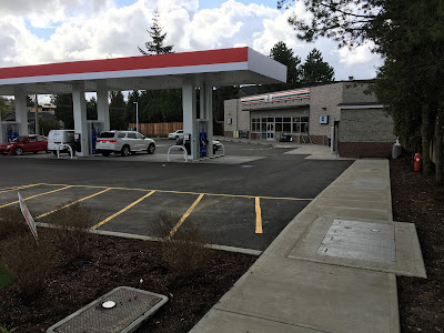
Back in September of 2015, I posted about the development permit for the 7-Eleven gas station that is now at the corner of 200th Street and 56th Avenue. The original design of the project had poor walking access to the store, and was even missing bike racks. People were expected to walk across the busy gas bar area, putting them in conflict with people driving.

Original site plan for 7-Eleven. Non-vehicle access was only to be provided from 56th Avenue via painted hashed lines through the gas bar. Select image to enlarge.

As you can read in my previous post, council requested that the developer include sidewalks from both 56th Avenue and 200th Street. The bike rack oversight was also corrected.

Recently, I snapped a few pictures of the walking access to the new 7-Eleven store.

Sidewalk from 200th Street to 7-Eleven. Select image to enlarge.

Sidewalk from 56th Avenue to 7-Eleven. Select image to enlarge.

Why is pedestrian access important? It is all about location. The area bound by 196th Street, 56th Avenue, 200th Street, and 53rd Avenue is where a significant amount of redevelopment in Langley City is occurring. Older single-family housing is being replaced with town houses and apartments. This area of Langley is about a 15-minute walk from Downtown Langley. Most people’s maximum walking time to a destination is 10 minutes.

This means that this area is too far from Downtown Langley for most people to choose to walk to the grocery stores or other amenities in our core. People will choose to drive to access a shop, even if only for a jug of milk. By having a walking-accessible shop nearby, some of the driving trip will turn into walking trips. This is better for people’s health and reduces traffic.

While the 7-Eleven at the corner of 200th Street and 56th Avenue clearly prioritizes auto access, the included sidewalks provide safe access to the convenience store. They support walking access to basic items in an area where driving would otherwise be the preferred mode of travel to access all necessities.

As Langley City's all ages and abilities cycling network is built-out, people in this area will also have the option to cycle to Downtown Langley though that is a topic for a future post.

Monday, April 17, 2017

Kelowna’s Downtown, ideas for Langley City

A few weeks ago, I released a travel survey about how people get to Downtown Langley. Close to 50% of locals walk to Downtown Langley while the vast majority of non-locals drive to Downtown Langley.

The City of Langley has been investing in Downtown Langley, improving sidewalks and public spaces. Our Downtown Master Plan also envisions replacing the current surface parking lots with mixed-use buildings (retail on the ground, offices/housing on the top floors) and public spaces.

Parking, of course, is important for the success of Downtown Langley, so the Downtown Master Plan calls on the construction of parkades.

Downtown Langley is starting to be known as the place where something fun is always happening. There is the McBurney Plaza Summer Series, Arts Alive, Bard in the Valley, Community Day, the Fork & Finger, and many other events that occur in the civic heart of our community. The latest City of Langley Financial Plan includes funding to expand on these free, family-friendly events.

One of the areas where there is currently a gap is positive evening activities in our Downtown core. Bring positive evening events and activities to Downtown Langley is certainly something that I support, and I know that others on City council support as well.

Over the Easter long-weekend, I visited my parents who live in Kelowna. I also stayed in a hotel in Downtown Kelowna for the first time.

I’m from the Okanagan; born in Kelowna and raised in Vernon. My memories of Downtown Kelowna were that of a warn, down-and-out area. The main street, Bernard Avenue, was a four-lane road with parking on the side, and marginal businesses. The place was dead at night. As a teen, my friends and I avoided Downtown Kelowna.

Downtown Kelowna has changed over the last 15 years, the City of Kelowna has been busy investing in their core over that time.

I decided to take some pictures of Downtown Kelowna which show some of the ways that they have transformed their Main Street and Downtown. These pictures show ideas that could be applied to Downtown Langley, and are generally consistent with our Downtown Master Plan.

One of the first things that I wanted to show is the $4 million parkade that the City of Kelowna built. One of the key design features of the parkade is that it has ground-level retail which contributes to the public realm. Without ground-level retail, parkades create dead-zones.

Chapman Parkade in Downtown Kelowna. Select image to enlarge.

Kelowna reduced the lanes on Bernard Avenue to support the creation of sidewalk patios for restaurants and cafes as well as seating areas.

Bernard Avenue in Downtown Kelowna. Select image to enlarge.

Sidewalk patios, and people using street tables and chairs on Bernard Avenue in Downtown Kelowna. Select image to enlarge.

Some of Kelowna’s Downtown alleys have also received makeovers.

An alley in Downtown Kelowna. Select image to enlarge.

With restaurants and cafes staying open later, combined with investments in the public realm that encourage positive activity in the evening, Downtown Kelowna is a happening place even once the sun goes down. The Downtown Kelowna Association has an “After 5pm” program.

Bernard Avenue in Downtown Kelowna at night. Select image to enlarge.

Building a great Downtown requires both investing in the public realm, and programming that public realm with events and activities. The City of Kelowna invests around a quarter of a million dollars on programming including the Festivals Kelowna organization.

While Kelowna has four times the population of Langley City, Langley City is the heart of Langley which has a similar combined population. Some of the things that I saw in Kelowna show what Downtown Langley could look like once our Downtown Master Plan is fully built-out.

Thursday, April 13, 2017

Mayors’ Council launches “Cure Congestion” campaign

Transportation in Metro Vancouver is front and centre currently as the provincial election campaigns for all parties gears up. All three major parties have committed to increasing funding for public transit in our region. Two of the parties have made promises about reducing or eliminating tolling in Metro Vancouver which, while popular, will increase congestion in our region.

While increasing public transit funding is good, there is still a hole as these commitments don’t cover all the costs of building new transit infrastructure, nor the costs of operating an expanded transit network.

As the Mayors’ Council on Regional Transportation has recently pointed out:

[The] announcements by two provincial parties on the future of the tolling system in Metro Vancouver demonstrates that transportation will be a key issue in this election. However, neither party has yet committed to workable solutions that will reduce congestion across our region over the long term. Completing the 10-Year Vision should be the first priority for our provincial and regional governments if we want to relieve congestion, improve affordability and protect the quality of life in Metro Vancouver.

The Mayors’ Council has launch a new campaign to “Cure Congestionwhich includes building new rapid transit lines, upgrading SkyTrain, increasing bus service, replacing the Pattullo Bridge, and investing in regional roads.

The goal of the “Cure Congestion” campaign is to get the main provincial parties to make a clear commitment to completing our region’s 10-Year Transportation Vision.

Wednesday, April 12, 2017

Draft plan for restored Hunter Park revealed

Last month, I posted about the community-driven Hunter Park Task Force, and Langley City staff’s planning work to restore the park. The park was devastated by Laminated Root Rot which required the City to remove a significant number of trees from the park.

The task force reviewed the concept plan for the restored park at the last task force meeting, and provided constructive feedback to City staff. With this feedback, staff went to work on a draft plan that was presented to the task force last night for further feedback.

The following drawing shows the new draft plan for the restored Hunter Park.

Draft site plan for the restored Hunter Park. Select image to enlarge.

The dark, heavy-stroke pen outlines the remaining trees in Hunter Park that will be preserved. Near these preserved trees will be planted areas. There will also be a new trail system in the park, as well as some grass areas to allow people to have a picnic or throw a frisbee around.

New trees will be added to the park, and as seen in the sample below will add a lot of colour to the park. Some of the trees will be flowering which will be beautiful to see during the spring.

Examples of trees that will be added to Hunter Park as part of the draft restoration plan. Select image to enlarge.

A low-level wood fence will front the park where it is parallel to streets. This will keep the park open and inviting, while preventing people from driving into the park, and will reduce the current build-up of debris around the edge of the park.

Example of fencing, benches, picnic tables, the trail system, and the iconic entrance that are part of the Hunter Park draft plan. Select image to enlarge.

Based on community feedback, the playground area will be enhanced with two picnic tables and several benches. There will also be an iconic entrance to the park off 45A Avenue near the playground area.

One of the elements in the draft plan for the restored Hunter Park will be interpretive signage about the park’s history. One of the members of the task force is knowledgeable about our local history. There is some mystery around how Hunter Park actually got its names. I’m hoping that this mystery will be solved with the installation of the interpretive signage.

Example of a historic document about Hunter Park. Select image to enlarge.

Members of the task force were pleased to see their feedback incorporated into the draft plan, and unanimously supported this draft plan. The draft plan will now be forwarded to council for approval at the April 24th council meeting. If approved, work will begin in short order to restore Hunter Park.

While there will no longer be an urban forest in Hunter Park, this plan does preserves the remaining trees and adds native-species planted areas. I am very pleased with this draft concept for the restored Hunter Park.

Tuesday, April 11, 2017

TransLink overall ridership up, efficiency improving

A few weeks ago, I posted about TransLink ridership statistics that were made available as part of the American Public Transit Association’s quarterly information release. The numbers from TransLink’s were for rail-based and SeaBus services. The numbers showed that ridership for SkyTrain was up 16% while ridership for SeaBus and West Coast Express was down.

TransLink has recently released their annual statutory report which contains overall ridership statistics. The numbers show some good trends for transit in our region.

2016 2015 % Change
Scheduled Ridership*
384,826 362,921
6.0%
Access Ridership*
1,366 1,340 1.9%
Schedule Operating Cost per Vehicle Km
$5.97 $5.89
1.4%
Access Operating Cost per Service Hour
$89.68 $87.90 2.0%
Schedule Farebox Recovery
55% 51.8% 8.2%
Overall Customer Satisfaction Score 60 57 n/a

Overall scheduled transit ridership was up in 2016; people are taking more transit trips in our region, and those trips are growing at a faster rate than population growth. Access transit aka HandyDART ridership was flat.

Operating cost recovery has also increased between 2015 and 2016. This means that fares are paying for more of the costs to deliver scheduled transit service.

Operating cost per total vehicle kilometres travelled has slightly increased for regular transit service at the rate of inflation. Access transit operating cost per service hour increased which is to be expected.

TransLink’s overall customer service score has also improved between 2015 and 2016.

Overall, it has been a good year for TransLink. The agency normally releases bus service performance information later during the year. It will be interesting to see where bus ridership is increasing and decreases, as bus service is the backbone of the transit network in our region, especially in the South of Fraser.

* per thousand.

Monday, April 10, 2017

Reducing or eliminating tolls will simply lead to more congestion and longer commute times for drivers

On Sunday, the BC Liberals announced that if they were re-elected, they would cap bridge tolls at $500 per year. Whether this is per vehicle or per account isn’t clear. Later during the day, the BC NDP came out saying that they would eliminated all bridge tolls.

While these announcements are certainly meant to win votes, they are both poor transportation policies. These policies will lead to more congestion on Metro Vancouver roads, increased pollution & GHG emissions, and will shift the burden of paying for costly bridges from people who use them to all British Colombians for decades to come.

People tend to think of traffic like water and roads like pipes. If you have more traffic flow (water) than a road (pipe) can handle, build a bigger road (pipe.) The problem is that traffic is more like air. It will simple fill the space you give it; you can’t build your way out of congestion.

The traffic modelling for the Massey Bridge shows that without a toll, the new bridge will simply result in more congestion.

Red circles show tolled and untolled traffic forecasts. TransLink's tolled traffic forecast: TL-RTM Tolled. Independent traffic forecast: SDG Independent. Select chart to enlarge.

Both the $500 toll cap and no-toll scenario will lead to more congestion. The BC NDP's no-toll plan will have a faster acceleration rate towards congestion than the BC Liberal's $500 toll cap plan.

TransLink's Golden Ears bridge had tolling revenue of $52.1 million last year. TransLink had to pay around $77 million in capital repayment and operating costs in 2016. The provincial Port Mann Bridge had tolling revenue of $135 million in 2016. The Port Mann had to be subsided by all British Columbians to the tune of $82 million.

By reducing or eliminating tolls, other tax sources will be used. The difference is that instead of people who use those bridges paying for them, everyone will be on the hook for these expensive boondoggles.

These policies also raise some questions about how transit expansion will be funded in our region. The region’s 10-Year Vision is dependence on road pricing in the next several years to be able to move forward. With the federal government promising to investing $2.2 billion into public transit in Metro Vancouver, hopefully the provincial government and mayors can figure out a new way to pay for their share of transit expansion costs.

The vast majority of trips do not cross a bridge in our region. In the South of Fraser, freeways circle our communities, but don’t go through them. Improving transit, cycling, and walking facilities, regardless of provincial tolling policy, is the only way to give people a way out of congestion without road pricing. I don’t see a freeway being punched through Surrey anytime soon.

I’m disappointed with both the transportation policies announced yesterday. I think a much better policy would have been to introduce road pricing, and eliminate gas tax.

Thursday, April 6, 2017

New Travel Survey Reveals How People Get to Downtown Langley

Downtown Langley is the civic, cultural, and commercial hub of our community. Because of its important roles, it is critical that safe, comfortable, and easy access be provided to everyone, no matter their mode of travel or where they start their journey.

A successful downtown is a multi-modal downtown where walking, cycling, taking transit, and driving are all viable options for access.

In order to plan for the future, it is critical to know what is happening today. During the summer of 2016, a travel survey of who accesses Downtown Langley, and how, was completed with the help of local merchants. The extensive survey found that 62% of trips to Downtown Langley were from outside of Langley City and close vicinity, while 38% of trips were local.

How local Langley City residents get downtown. Select graph to enlarge.

Of the regional trips, the majority of trips (84%) to Downtown Langley were by driving. For local trips, around 50% of trips to Downtown were on foot.

How people from the rest of the region get downtown. Select graph to enlarge.

Looking at the results of the survey, it is important that parking in the Downtown is managed to ensure that people visiting have convenient access to parking facilities. Walking is a significant mode of travel for locals who visited Downtown Langley. It is important that sidewalks and the public realm within Downtown Langley be inviting and safe, and that walking from other areas within the City of Langley to Downtown be safe and inviting as well.

Cycling and taking transit to Downtown were not significant modes of travel. Langley City has only just recently started to invest in cycling infrastructure. TransLink is planning to increase transit service to Downtown Langley by introducing a new B-Line route in the near future. As investments are made in these modes of travel, results from other communities show that the amount of people using them will increase.

This survey would not have been possible without the support of Downtown Langley Merchants.

The full results of the travel survey, “Going to town”, can be downloaded from the document archive.

Wednesday, April 5, 2017

April 3rd, 2017 Council Meeting Notes: More citizen task groups formed, and rezoning applications in-progress including Carroll Court replacement

Last December, there was a public hearing for a proposed townhouse project at 198 Street and 55 Avenue. During the public hearing, some people expressed concern about traffic speed and unsafe parking. As I noted in the post about the public hearing, there will be changes to the street design to reduce speeding and discourage unsafe parking. The proponent of the project also will be making the parking within the townhouses large-vehicle friendly.

Unrelated to this project, but important to note is that the City of Langley is also adding additional traffic calming in the area.

At Monday night’s council meeting, this project’s rezoning application and its development permit were approved.

Council also gave first and second reading to a rezoning application for two proposed apartment buildings. Giving first and second reading, allows a public hearing to be scheduled at a future council meeting. It also allows a conversation at that meeting about if the projects conform to our official community plan, zoning bylaw, and development guidelines.

The first proposal is for a 4-storey apartment building at 54 Avenue and 198 Street.

Rendering of the proposed apartment building located at 198 Street and 54 Avenue. Select image to enlarge.

The second proposal is for a 5-storey apartment building along 201A Street were Carroll Court, which was damaged in a fire, and Merton Court are currently being demolished.

Rendering of the proposed apartment building along 201A Street. Select image to enlarge.

During December, Langley City council moved to a goal-oriented task group model for its citizen committees. The latest task group to be formed is the “Develop a Sustainable Program” to “Deter Crime and Target Crime Hot Spots” Task Group.

On Monday, I was appointed to the task group along with the following Langley City citizens: Vivian Thompson, Lynn Whitehouse, Sandy Dunkley, Davis Krell, and Valerie Frolander.

Councillor Martin was appointed to the Homelessness Action Table Task Group.

To find out about other items covered at Monday night’s council meeting, please read my previous post on the meeting.

Tuesday, April 4, 2017

April 3rd, 2017 Council Meeting Notes: Multi-million dollar investments in roads and parks, Youth Week, and Langley Volunteers.

Last night’s council meeting started with a Committee of the Whole to allow Langley City residents and property owners to comment on the proposed closing of a small turn-around in a lane near 204th Street and Park Avenue that is no longer required. I posted about this in my notes about the March 20th, 2017 council meeting. There were no public comments, and later during the meeting council approval the closure.

Zosia Ettenberg and Sylvia Anderson, on behalf of all board members of the recently created Langley Volunteer Bureau, delivered a presentation about their recently created society. The propose of Langley Volunteers is to connect volunteers with non-profit organizations that need volunteers. The society is the result of early work between the Greater Langley Chamber of Commerce, Envision Financial, and Volinspire.

The first event of the society will be a meet and great on Saturday, April 22nd from 1pm to 4pm at Douglas Community Centre. It will provide an opportunity to talk to Langley non-profits and event planners. For more information, please visit the Langley Volunteer website.

Langley City Council receiving an Engineering and Parks Update. Select image to enlarge.

Council received an Engineering and Parks update. Work is continuing for the 203rd Street project with the grand opening now slated for June 9th.

Crews are also busy with $1.3 million in upgrades for the Penzer Action Park. Work is expected to be completed this summer.

The 56th Avenue Improvement Project is about to begin. Council approved the $4.2 million tender to Richco Contracting Ltd. The project will include upgrading aging water and sewer mains, plus new sidewalks, new streetlights, new street tress, new cycling lanes, and fresh asphalt. This City will be hosting a public information session on:

Date: April 12, 2017
Time: 6:00 PM to 7:00 PM
Location: Langley City Hall, 20399 Douglas Crescent Council Chambers, 2nd Floor

Work is also starting on the 48th Avenue Improvement Project. The project will result in a widened 48 Avenue on the north side from 200 Street to 201 Street to allow for sidewalks and bike lanes.

Water mains are currently being flushed in the City. If you notice cloudy water, it’s safe to drink. Running your water will reduce the cloudiness.

City crews also completed bank restoration work along Baldi Creek by the old BC Hydro right-of-way, and have been busy replacing the storm sewer along Newlands Drive. They have also been completing walkway maintenance. Due to this winter’s crazy weather, City crews have been patching a higher number of potholes. If you see a pothole, please report it to the City.

After the Engineering Update, we received a Recreation and Culture Update.

To celebrate Canada’s 150th, Langley City will be taking part in National Canadian Film Day on April 19th. There will be free movies being screened and free popcorn available at Langley City Hall. For more information on movie show times, visit the City’s website.

Youth Week is coming up in the first week of May. There will be a metric ton of activities for young people including building a community garden at HD Stafford, an Art Show/Battle, an Amazing Race through the City, and a “Carnival” from 6pm to 9pm on Saturday, May 6th. I will post a link with more information when it becomes available.

With the start of spring, comes a lot of activities in our community. Tomorrow, I’ll be posting about the remaining items, including rezoning applications, from Monday night’s council agenda.

Monday, April 3, 2017

Transit funding in Metro Vancouver: three steps forward, one step back

Transit and regional transportation is improving in our region. Much of this is thanks to the federal government’s renewed interest in funding public transit. In 2015, things were looking bleak for transit expansion in our region. The federal government provided ad-hoc funding for cherry-picked transit projects, and would only pay up to 33% of project costs. The provincial government was committed to paying for 33% of the cost of transit projects. The regional had to pick up the tab for the remaining 33% of project costs, plus the on-going operating costs of running an expanded transit system.

Map of regional transportation investments. Source: Regional Transportation Investments a Vision for Metro Vancouver. Select map to enlarge.

The region’s mayors and the province locked horns over how Metro Vancouver was going to pay for its local share of transit costs. The region’s mayors wanted carbon tax and mobility pricing, the province was only interested in increasing property tax.

With the change in federal government, was a change in how transit projects would be funding. In the 2016-17 budget, the federal government committed to funding up to 50% of transit project costs, and make predictable funding available.

There was the potential for both the federal and provincial governments to cover 83% of the project costs for transit expansion.

The funding got all parties to the table which is why TransLink is now able to start the process of expanding transit service in the region. The mayors agreed to increasing property tax above the normal 3% per year, and the province agreed to look at a Regional Development Cost Charge for Transit.

There was still a big question about whether the federal government would continue to provide predicable, long-term funding for public transit projects. There was also still a $50 million per year hole in transit funding which would grow to $100 million per year in 2022. The region still wanted the provincial government to approved a new regionally-sourced, provincially controlled funding source, plus commit to introducing mobility pricing by 2021.

The most recent federal budget confirmed that predictable, long-term funding for transit projects would be available federally. While the federal government still has committed to paying for up to 50% of transit project costs, the funding made available for our region works out to 40% of project costs. On Friday, the provincial government committed to fund-matching “dollar-for-dollar the federal government’s 11-year commitment of up to $2.2 billion investment in new projects, including our commitments to new rapid transit projects in Surrey and Vancouver.”

What this means is that the federal and provincial governments have now committed to covering 80% of transit project costs. This leaves a larger gap for funding the full regional transportation plan than was thought last summer, but that gap is much smaller than it was in 2015.

So, what are the steps forward? Well, I think that the provincial government is still committed to a Regional Development Cost Charge for Transit. I believe that long-term mobility pricing will happen.

The challenge is plugging that $50 million plus hole with a new regionally-sourced, provincially controlled funding source. I don’t see that in the cards currently.

In order to move things forwards, our region’s mayors may need to look at increasing property tax once more for transit to plug that hole. It would work out to about $8 more per year for the average house in our region. $8 more per year for rail rapid transit throughout the South of Fraser, including to Langley, seems worth it.

We are closer than ever to having a fully-funded regional transportation plan. Over the next year, I hope that the provincial government and region’s mayors will be able to figure out how to close the current funding gap.