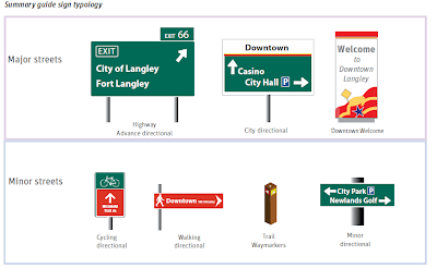
Arrival in the Downtown area is not well-defined. This is mainly because there is no significant change in built form or character from the surrounding area.I hope that council approves the strategy tonight as it will be a step in the right direction. Of course signage is only 10% of the solution, the City needs a built form that actually supports sustainable transportation. Below is an example of some of the proposed signs to be installed.
The City is dominated by major roads, with the Langley Bypass, Fraser Highway, 200th Street and 203rd Street: Street carrying the highest traffic flows. Within the City, these streets are between four and six lanes wide and can be even wider at their intersections leading to long waits for cross walk signals.
Major roads are fronted by malls and big-box development which is invariably set back from the highway to provide large parking lots. Heavy traffic and set back development creates a car oriented environment that reduces the free and easy movement of people on foot.
Langley’s environment is one designed around car access. Drive-thrus, large surface parking lots between buildings and the highway and the absence of obvious walking routes all point to this fact.
There is no shortage of parking in the City, but little obvious enforcement of the unauthorized use of private spaces, the visitor is presented with a confusing range of options.
Even where distances are not great, the perception is that they are because the walking environment is so poor. For example, the Downtown Core is 20 minutes walk from Willowbrook Shopping Centre, but the Fraser Highway is such as poor pedestrian environment that it is not a journey that is undertaken.
 |
| Proposed Wayfinding Signage. Click Image to Enlarge. |
To encouraging new cyclists to undertake everyday journeys rather than experienced cyclists or leisure cycling; the proposed priority for signs would be routes that link residential areas with the Downtown via quieter streets and off-street trails and routes that link residential areas with workplaces and places of education via quieter streets and off-street trails.
The projects for the plan would be:
Project 1 - City Map
Project 2 - City Directions
Project 3 - Highway Signage
Project 4 - Downtown Orientation
Project 5 - Cycling Network
Project 6 - Walking Network
Project 7 - Construction Wayfinding
Project 8 - City Gateways
Project 9 - Explore Downtown
Project 10 - Transit Information
The cycling and walking signage would be installed in 2013 if council approves this plan.
---
On the topic of wayfinding, the report also contains samples of TransLink's proposed new bus stop signage. If this replaced the current useless “BUS STOP” signage currently in use, I would cry tears of joy!
 |
| Proposed TransLink Bus Stop Sings. Click Image to Enlarge. |

No comments:
Post a Comment