Thursday, August 31, 2023

Understanding Langley City's Transportation Network: Where We Are Prioritizing Walking, Cycling, and Transit

Yesterday, I posted about why we are prioritizing walking and cycling in Langley City and how the region is prioritizing transit to give people more safe, cost-effective and convenient travel options. Today, I wanted to explore how this is proposed to roll out in Langley City.

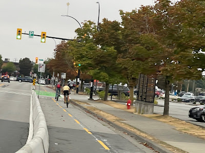
A protected cycling lane on Douglas Crescent.

Langley City will have two SkyTrain stations—one at the Willowbrook Mall and one at 203rd Street and Industrial Avenue. The areas within a 10-minute walk of these stations will be the priority areas for building high-quality streetscapes and wide sidewalks. The following map shows these areas.
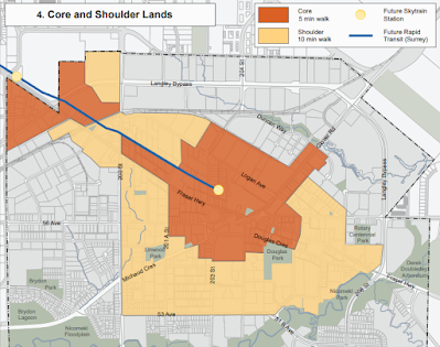
The 5- and 10-minute walking area to the two Langley City SkyTrain Stations. Select the map to enlarge.

Langley City will, over time, continue to complete the sidewalk network in the rest of our community.

Langley City is only 10 square kilometres. On an e-bike, I can get from my place near Sam's Pub to Councillor Solyom's house in the Uplands Neighbourhood (the furthest distance you can travel within our community) in under 15 minutes. Put another way, we have a compact community ideal for cycling.

We want to make it easy for people outside the 10-minute walking area to bike into that area, as shown on the previous map. The City will prioritize building a cycling network to get people safely to our walkable core and SkyTrain stations. The province will also build a safe cycling connection between the SkyTrain stations as part of the SkyTrain project.

Langley City is prioritizing cycling access for the Brydon Neighbourhood, upgrading existing bike lanes, closing gaps in our cycling network, and completing the Grade Crescent Greenway. These priorities also align well with the location of most schools in our community, so kids have safe cycling infrastructure as well.

Over time, the goal will be to have safe cycling infrastructure on all major streets in Langley City.

While most trips people take are under 5km, whether in Langley City, Vancouver, or Maple Ridge, transit comes into play for longer trips. Besides the two SkyTrain Stations, Langley will have Bus Rapid Transit along or near the 200th Street corridor in the coming decade.

Between SkyTrain and Bus Rapid Transit, about 75% of the area of Langley City will be within a 10-minute walk of fast, frequent transit. For everyone else, they will be within a 10-minute bike ride of a SkyTrain station.

Now, we know that driving will still be a way for people to get around, especially for commercial purposes. Giving people more travel options will free up road capacity for commercial traffic.

For more information about Langley City's proposed transportation network plan, please visit our Transportation 2045 page.

As a note, our walking infrastructure must be universal, meaning that people who use mobility aids should be able to use it comfortably. Cycling infrastructure also includes micro-mobility in general, such as scooters and skateboards.

Wednesday, August 30, 2023

Why we are focusing on walking, cycling, and transit in Langley City and Metro Vancouver

From time to time, I get questions from community members asking why Langley City is investing in cycling infrastructure and how it fits into the bigger picture of enabling people to move around in Langley City and our region. I wanted to expand on this over a few posts.

Young people cycling on Douglas Crescent

The priority transportation investments in Langley City are to make walking and cycling safe and inviting. This is coupled with the regional focus on building fast, frequent, and convenient transit, including building SkyTrain to Langley City. But why?

There are four reasons.

First, as our population grows, we need to be more efficient with our transportation network as we don't have the space or money to widen roads in Langley City and many other parts of our region. Widening roads in urban areas is a destructive process as well. A road with generous sidewalks, protected cycling lanes, and bus lanes can handle an order of magnitude more people per hour than a conventional road, as people walking, cycling, or taking a bus use less space. As more people walk, cycle, and take transit, they drive less, reducing congestion. This frees up road space for tradespeople and commercial traffic.

The second reason is that it offers more cost-effective travel options. Life is expensive, and many households own more than one car. The Canadian Automobile Association has a car ownership cost calculator. Owning and operating a car costs about $10,000 per year in BC. It is even more if you own an SUV or pickup. When people have safe and convenient walking, cycling, and transit options, households could go from two or three cars to one car, which puts significant money back into people's pockets.

The third reason is car ownership's health costs. It is the direct link between high speeds, traffic volumes and increased crashes that cause injury and death, the direct link between air and noise pollution and its negative impact on human health.

The final reason is the environmental impacts of GHG emissions and battery production. The fewer cars on the road, the better it is for the environment.

Focusing on walking, cycling, and transit helps more people get where they need to go, puts significant money back into their pockets, improves their health, and cleans up the environment. This is why we are focusing on this in Langley City.

In my next post, I'll discuss how this will look on the ground in Langley City.

As a note, walking includes using mobility assistance devices. We need to ensure that as we build out walking infrastructure, it is universally accessible to all people.

Tuesday, August 29, 2023

Why does it cost so much to build transit in Metro Vancouver? Lessons from Continental Europe

Over the last few weeks, I have been on a holiday that took me through parts of France, Germany, and the Netherlands. While I was there, there were several news stories about how it cost way more to build transportation infrastructure in the UK compared to the rest of continental Europe. It costs about double. They included Canada and the US in their comparison, and we faired even worse.

Sam Dumitriu, who works for Britain Remade, detailed this information in the post, "Britain's infrastructure is too expensive."

What contributed to lower transportation project costs in places like Spain, France, and Germany? They used off-the-shelf equipment, no-frills designs, and cost-effective construction.

In Strasbourg, they were debating building a SkyTrain-type system or a tram network in the 1980s. Many people wanted to build the SkyTrain-type system because it would have less impact on driving and parking.

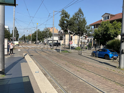
I had a chance to ride their tram network in Strasbourg, France. It opened in 1994 and has been continually expanding. It was four times less costly than their originally proposed SkyTrain-type system.

The first picture shows the Landsberg Tram Station in Strasbourg.

Landsberg Tram Station in Strasbourg. Select the image to enlarge.

The second picture shows how they adopted four-lane roads for transit, walking, and cycling.

Mother and Child Crossing Street with a Tramway on Bikes in Strasbourg. Select the image to enlarge.

So, what does this have to do with Metro Vancouver?

While I'm proud of our SkyTrain system, it is one-of-a-kind, which means that compared to other rapid transit systems, it does cost more to build.

The TransLink Mayors' Council wants to get more high-quality transit to more people and places in our region over the next decade than ever before. While we are committed to building SkyTrain to UBC and Langley, the future of rapid transit in our region will be Bus Rapid Transit.

What makes transit networks great isn't whether it is built with rails or rubber (buses) but whether it is fast, frequent, and convenient.

We will build more transit per dollar using off-the-shelf buses, traffic light prioritization, high-quality but no-fills stations, and existing road right-of-ways.

Building cost-effective rapid transit is the way to go, but change management challenges exist. We will have to change some general travel lanes to bus-only lanes along many bus rapid transit corridors. While most folks in our region support building high-quality transit, there will be opposition to reallocating road space. In some communities, this opposition may give elected representatives pause. I remember that RapidBus didn't continue to Ambleside but stopped at Park Royal in West Vancouver due to the opposition to reallocating road space.

While we can build cost-effective rapid transit in Metro Vancouver, there will be tough political decisions to be made in some communities.

Monday, August 28, 2023

How we actually lower the cost of housing in Metro Vancouver

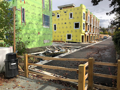
A townhouse project under construction

Over the past few weeks, I've been out of town and taking a break from blogging, but I have been thinking a lot about housing and how we seriously move the needle to return housing prices to a normal level in Metro Vancouver.

The first question is, what is a normal level? In the CMHC report, "Housing Shortages in Canada: Solving the Affordability Crisis," the authors note that households in BC historically spent no more than 44% of their pre-tax income on housing.

Using Langley City, the average income for a household in 2020 was $89,400. About 50% of the households in Langley City make this income or more.

These households should be able to buy or rent housing at market rates built by for-profit developers. This isn't the case today, with many households spending 60% or more of their income on housing.

So, how do we drive down the cost of housing in a meaningful way in Metro Vancouver?

The first is to lower the cost of land. Most land within our Urban Containment Boundary is zoned for single-detached housing in Metro Vancouver. This zoning restriction puts a premium on land zoned for higher densities.

I did a straightforward search on Reator.ca in Langley City. The property at 20196 48 Avenue is selling for $149/sq. ft. Meanwhile, 20214 52 Avenue, a 5-minute walk down the street, is selling for $278/sq. ft. The 48 Avenue property is in a single-detached area, while 20214 52 Avenue is in a low-rise attached housing area.

Building a townhouse, excluding land, costs about $233/sq. ft. in Metro Vancouver. Increasing the land supply to accommodate townhouses will lower the land cost, driving meaningful savings for people buying or renting a home. This is simple supply and demand.

The provincial government understands this is a concern, so they will be requiring municipalities to allow up to four housing units per residential lot in BC. While I understand this, a much better approach to driving down land costs would be to enable a minimum FAR of 1.4 for all resident areas within the Urban Containment Boundary of Metro Vancouver. This would enable cost-effective land assemblies and the typical three-story townhouse format we see in Metro Vancouver. Municipalities cannot do this piecemeal, so it would have to be mandated or strongly encouraged by the provincial government to drive meaningful cost savings across Metro Vancouver.

We also know that borrowing money impacts the cost of building housing. The provincial and federal governments should help developers to get lower-interest loans for building market rental and ownership townhouses and apartments, not just below-market housing.

Another significant cost driver for housing is municipal parking requirements. Looking at the typical three-storey townhouse, about 1/3 of the square footage is for parking. We must remove minimum parking requirements. I know this can be tricky as parking is a third-rail issue in some communities. Still, many North American municipalities are removing or reducing parking requirements to reduce housing costs.

As they say, time is money, and waiting a year to go through the approval process at City Hall wouldn't cut it. The provincial government must set service-level targets that municipalities should meet and work with municipalities through UBCM to help us achieve those targets by providing support.

The home construction industry needs to become more productive. Simply put, the same amount of people working in the industry will need to build more housing units faster. The province must work with the industry to help improve productivity.

The final piece of the puzzle is to add transparency to buying new homes. Many people tell me, "Nathan, for all the cost savings you're talking about, developers will just take that as profit." This is why we should have updated disclosure statements for every new home. These statements should show the land costs, construction costs, development fee costs, financing costs, and profit per square foot for a new home. The province should also centrally track this information and make it publicly available to ensure developers are not exploiting folks.

I didn't talk about non-market housing in this post. We must build more of it, but lowering the cost of market housing will help the most people, the faster.

Thursday, August 10, 2023

Some Random Thoughts About Being Mayor of Langley City

In August, local government elected representatives do not meet. This time off gives folks a chance to reflect and recharge. As such, I thought it would be a good opportunity to reflect on my first season as Mayor of Langley City.

One of the things I knew when running for Mayor is that there is more accountability to the community. As a Councillor, I was accountable for my actions. As the Mayor, I am accountable for my actions, the actions of Council, and the actions of the municipality. I have certainly felt that increased accountability. It can be stressful at times.

When people reach out to the Mayor, they generally believe I have more power than I actually have. I am continually surprised by the number of "special favours" people request of the Mayor. Folks want the Mayor to "fix" parking tickets, remove late payment penalties, have inspectors look the other way for building code violations, and speed through their subdivision or development applications. I'm OK with saying no to these requests.

I've also observed that people want to express their opinions about the world's state of affairs to me. Because the Langley City Mayor is a lot easier to get a hold of than the Premier or Prime Minister, I've found that the role of the Mayor is also providing an opportunity for people to express their concerns, even if the opportunity to action those concerns is limited.

As Mayor, I love when I can take action on an idea or request from a resident or business owner by bringing it to a City department or City Council to consider.

Between the Metro Vancouver Regional District, Fraser Valley Regional Library Board, Mayors' Council, City Council and committees, external committees, meetings with residents and businesses, and attending events, you could find yourself burnt out pretty quickly as Mayor. I needed to delegate responsibilities to other members of Council.

I'm glad that Councillor Paul Albrecht and Councillor Rosemary Wallace share responsibilities for the Metro Vancouver Regional District and Fraser Valley Regional Library Board.

Previous Mayors attended a bunch of other external committees that I'm happy to have delegated to other members of Council, such as Councillor Teri James, who attends Gateway of Hope Community Council or Councillor Leith White, who attends the Healthier Community Partnerships.

Councillor Delaney Malack and Councillor Mike Solyom serve on internal committees.

With many community events to attend, it has been important for me to share this responsibility with the Deputy Mayor. The role rotates among all members of Council

I heard the saying don't let the urgent override the important, and this resonates with me. I'm still learning this lesson. I constantly need to check that what the City and I are doing is consistent with Council's strategic priorities and that we are moving those priorities forward.

I've also learned that it is important that every member of Council sees a part of their vision for the community reflected in the City's policies and actions.

Politics, unfortunately, lends itself to a lot of gossip at the local level. I must continually check myself to ensure I don't get sucked into the day's gossip. I approach people from a place of trust regardless of the gossip because in the end a person's actions show what is important to them and what kind of person they are.

My final observation is to avoid getting involved in things that don't directly impact Langley City or the overall Metro Vancouver region. It is a surefire way to get into trouble. At the beginning of my term, I got invitations from the Government of China and the Government of Taiwan to meet. I decline both of those invites.

I'm excited about the future of Langley City, and I look forward to September, but over the next few weeks, I'll be taking a break.

Wednesday, August 9, 2023

New TransLink Report: Bus Congestion Shows Need for Increase Transit Priority Infrastructure

Over the past year, TransLink has been releasing their 2023 Bus Speed & Reliability Report. Earlier in the year, they released information about transit delays due to congestion and the percentage of people that use transit along select transit corridors during peak periods. I posted about this earlier in the year.

TransLink has added new information to its report, so I wanted to examine the South of Fraser context further.

The following map shows how much delay transit riders experience due to congestion. The purple and red sections show where delay is a significant concern.

Map of 2021 Person-Hours of Delay per km on Transit in the South of Fraser. Select the map to enlarge.

The Scott Road, 104 Avenue, 72 Avenue, and Fraser Highway corridors are in Metro Vancouver's top 20 most congested transit corridors.

The way to reduce delay is to introduce transit priority measures, such as what we've done in Langley City on select corridors.

Bus-Only Lane on 203rd Street in Langley City. Select the image to enlarge.

Around 21-35% of people who travel along Fraser Highway do so on public transit during peak travel periods. In Langley, 33-58% of people using the 200th Street corridor do so by public transit during peak travel. These percentages are something to remember, as sometimes bus prioritization means redesignating general travel lanes.

The following map shows transit priority measures installed to date. The dark green lines are bus lanes, and the yellow dots are intersection measures such as queue jumper lanes and transit priority traffic signals.

Map of Transit Prioritization Infrastructure in the South of Fraser. Select the map to enlarge.

As you can see, we have some ways to go in the South of Fraser. TransLink is willing to fund transit priority measures, but municipalities must also be willing. It does take political capital.

Tuesday, August 8, 2023

A Tour by Mayor Leonard of Bowen Island: Metro Vancouver Regional Parks and their Oversized Impact

On Saturday, Councillor Paul Albrecht and I visited the Mayor of Bowen Island, Andrew Leonard. Mayor Leonard gave us a tour of the island and provided some important insights.

Me, Councillor Paul Albrecht and Mayor Andrew Leonard at Cape Roger Curtis. Select the image to enlarge.

Councillor Albrecht is Langley City Council's appointee to the Metro Vancouver Regional District Board, and I serve on the Mayors' Council for Regional Transportation. In these roles, we must make decisions for the whole region. It is essential to understand the context of all parts of our region to make better decisions, which is why I've been visiting the mayors of other municipalities in their communities.

Bowen Island is a unique municipality within Metro Vancouver in more than one way. Besides being the only island municipality in BC, it is also part of the Islands Trust, so it has a legislative requirement to "preserve and protect" the environment and the island way of life. After Crown land, the Metro Vancouver Regional District is the second largest landholder on the island for its regional parks. These parks create some unique challenges for the island.

Mayor Leonard noted that about half the ferry trips are for folks visiting Crippen Regional Park. For a small island community of 4,256, this creates an oversized impact on their community.

Passengers disembarking at Snug Cove on Bowen Island. Select the image to enlarge.

The Metro Vancouver Regional District recently acquired land to build another regional park on the island at Cape Roger Curtis. I posted about this previously.

The long-term plan for the new park will be to have 52 walk-in/bike-in campsites, 33 drive-in campsites, and 40 day-use parking spots. Traditionally, people drive to regional parks for camping, but for Cape Roger Curtis, there is the opportunity to do things differently.

A proposed campsite location at Cape Roger Curtis. Select the image to enlarge.

Mayor Leonard drove Councillor Albrecht and me to Cape Roger Curtis. You travel on a narrow road through a residential neighbourhood to access the park.

With limited parking and poor driving access, this park must be accessible by public transit thru the Metro Vancouver Regional District, TransLink, or both. Mayor Leonard said the 33 drive-in campsites should be replaced with additional walk-in/bike-in campsites as it is one of the few parks with camping in Metro Vancouver that is easier to access via public transit from the rest of the region.

For example, someone in Whalley could take the SkyTrain to Downtown Vancouver, hop on the Horsebay Express, then ferry to the island in a few hours.

The other item of importance for Bowen Island to effectively serve Metro Vancouver Regional Park visitors is completing the Bowen Island Multi-Use Path Project. Given that the Regional District creates 35% of the trips to the island, it makes sense that we, as a region, contribute to completing this path project.

While the Regional District is considering walking, cycling, and transit as a way to access its parks on Bowen Island, the understanding I got from Mayor Leonard is they are still thinking that driving would be the primary way for people to access these parks.

Given our region's goal to reduce motor vehicle trips, Bowen Island would be the perfect place to practice what we preach, to create parks that are accessible primarily via walking, cycling, and transit and where driving is actively discouraged. This people-first access approach also seems to be what the Bowen Island community supports.

Thursday, August 3, 2023

July 24 Public Hearing Notes: 6-storey, 75-unit apartment on 54A Ave

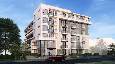
On July 24th, Langley City Council held a public hearing for a rezoning bylaw that, if approved, would allow for a 6-storey, 75-unit apartment at 20214-24 54A Avenue.

A rendering of a proposed building at 20214 & 20224 54A Avenue. Select the image to enlarge.

Because this site is within a 5-10 minute walk of the future 203rd Street SkyTrain Station, which the province plans to start construction on next year, Langley City's Official Community Plan allows up to 12-storey buildings in that part of town. The highest densities in the City will be within a 10-minute or less walk to our two SkyTrain stations. Beyond the 10-minute walk area, the maximum height for apartments is six stories.

Because the proposed project would redevelop an existing market rental building, this project is subject to Langley City's tenant relocation policy which includes provisions to help tenants relocate with the assistance of a tenant relocation coordinator, help with moving and moving expenses, the right to move back into the new building at 10% below market rental rates, and compensation. For vulnerable tenants, the policy includes additional help and compensation. For more information, please read Langley City's Tenant Relocation Plans policy. The applicant at the public hearing noted they would provide an additional one month of rent compensation above City policy.

This project is subject to Langley City's one-for-one rental replacement policy. As such, the project will include eight new purpose-built rental units ranging from studio to two-bedroom units.

The public hearing was well attended, and Council received several emails about the proposed project.

Generally, the concerns centred around the height of the building and shadow impacts on adjacent apartment buildings, on-street parking, traffic, and construction impacts. With the cave-in issue at the project being built at the former site of the West Country Hotel, folks were concerned about cave-ins of the underground parking.

The applicant's geotechnical engineer tried to assure people at the public hearing that the construction plan for the underground parking would ensure no cave-in event.

Langley City staff noted that the City is working on an on-street parking management plan for the whole City, that all redevelopment projects are subject to a traffic impact/mitigation process, and that all development projects must have a construction management plan to help mitigate the impacts of construction.

Specific to this proposed project, trees along the property line must be removed. These tree removals were vehemently opposed by the strata councils of the adjacent apartments as the trees straddle both the applicant property and the stratas'.

One person at the public hearing suggested installing a concave mirror in the alley to help with vehicle navigation and safety.

Council will consider the written and verbal feedback from the public hearing. Council is not able to consider any other feedback from the public per BC law.

Council will consider third reading of the rezoning in the fall.

Wednesday, August 2, 2023

July 24 Council Notes: 6- and 8-storey apartment projects, $15 million loan, industrial zoning change, personal services businesses

As I recently posted about, Langley City completed an Alternate Approval Process for a $15 million loan to help purchase property to support SkyTrain and fund the renewal of the Fraser Highway One Way.

Last Monday, Langley City Council gave final reading to the bylaw authorizing this borrowing. The provincial government must now approve the bylaw. Once approved by the provincial government, it will also need to be approved by the Metro Vancouver Regional District Board, as all borrowing in BC is facilitated thru regional districts. This borrowing process, from budget approval to getting "money in the bank," usually takes around a year.

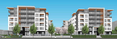
At that meeting, Council also gave first and second reading to a bylaw enabling the construction of a two-building, 6-storey, 171-unit apartment project at 20659 - 20679 Eastleigh Crescent.

Rendering of proposed project at 20659 - 20679 Eastleigh Crescent. Select the image to enlarge.

This project is subject to Langley City's tenant relocation and one-for-one rental replacement policies. As such, the applicant will need to provide 21 purpose-built rental units. The applicant proposes a 50/50 rental unit mix of one- and two-bedroom units ranging from 557 to 805 sq. ft. All the rental units will have air conditioning.

The buildings step down to four stories on the northeast side to help reduce shadowing on the adjacent Wyndham Lane townhouse complex.

Council also gave third reading to a proposed 8-storey, 78-unit apartment at 5404, 5406, 5408 and 5414 207 Street. You can read more about this project in my previous posts about first and second reading, and the public hearing.

A rendering of the proposed project at 5404, 5406, 5408 and 5414 207 Street. Select the image to enlarge.

Council gave third and final reading to update our zoning bylaw to allow taller industrial buildings (from 15 metres to 30 metres), up to 10% of an industrial site to have office uses, and to reduce the parking requirements for industrial buildings to 1 space per 100 m2 in the I1 zone.

Council also gave third and final reading to require a 400-metre separation distance between businesses that provide the following services: hair cuts, hair styling, hair chemical treatment, pedicures, manicures, facials, lashes, microdermabrasion, microblading, permanent make-up, waxing, laser, hydro, anti-aging, skin rejuvenation theray, shiatsu, acupressure, reflexology, bio-kinesiology, hellework, polarity, reiki, rolfing, trager and other touch therapies and techniques.

As I noticed previously, existing business locations will be grandfathered to allow these uses. If a beauty/nail/hair/skincare salon or nonregistered massage establishment closed down, that location could be used for a future business of the same type within six months. Only after six months of beauty/nail/hair/skincare salon or nonregistered massage establishment being closed at a location would the 400-metre separation distance take effect.

Council also gave the final reading to update our Municipal Ticking Information System Bylaw. This bylaw is a housekeeping matter and allows for fines of up to $100 for infractions of our Parks & Public Facilities Bylaw.

Tuesday, August 1, 2023

Langley City Council Adopts Townhome & Plex-Home Best Practices Guide, Lifts Moratorium South of 50th Avenue

Langley City's Official Community Plan's land-use vision includes townhomes and 'plexes along the 200th Street and 208th Street corridors south of the Nicomekl River.

In the spring of 2022, Langley City Council placed a moratorium on townhomes and 'plexes rezoning applications south of 50th Avenue. Council put this moratorium in place due to near-universal concern expressed by people in the Uplands Neighbourhood about how townhomes and 'plexes would integrate into their neighbourhood.

Two of the conditions to lift the moratorium were to create a survey to get feedback from residents, which would feed into creating a best practices guide for townhomes and 'plexes development along the 200th Street and 208th Street corridors. Council adopted this best practices guide at its July 24th Council meeting.

A drawing of how townhouses and single-detached housing can co-exist. Select the image to enlarge.

The best practices guide includes the following sections:

  • Rooftop Patios and Balconies
  • Rooftop Styles
  • Transportation Improvements
  • Green Space and Landscaping
  • Building Heights
  • Building Setbacks
  • Garage Styles and Parking
  • Amenity Spaces

I encourage you to read the Townhome & Plex-Home Best Practices Guide.

The final two conditions to lift the moratorium were to complete a traffic and parking study for the Upland Neighbourhood south of Newlands Drive and east of 208th Street (the study area) and to incorporate any mitigation measures into the City's capital budget.

Langley City staff completed the traffic study and determined that the neighbourhood will need a full traffic signal at 208 Street and 45A Avenue. The traffic signal is scheduled to be operational by April 2024 and funded by redevelopment.

The parking study found there are 120 on-street parking spaces in the study area. The parking study determined there could be a maximum of 59 townhomes or 'plex units built in the study area, which would require 130 parking spots to be included within townhome or 'plex projects. The single-detached houses have 374 parking spots on their lots. There would be 624 parking spots in the study area at full build-out. The math works out to 2.4 parking spots per housing unit in the study area, above the City's requirement of 2 spaces per unit.

As the conditions to lift the moratorium were met, Council voted to lift the moratorium.