Yesterday, I posted about why we are prioritizing walking and cycling in Langley City and how the region is prioritizing transit to give people more safe, cost-effective and convenient travel options. Today, I wanted to explore how this is proposed to roll out in Langley City.

|
| A protected cycling lane on Douglas Crescent. |
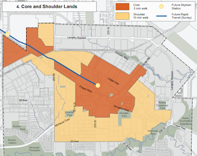
Langley City will have two SkyTrain stations—one at the Willowbrook Mall and one at 203rd Street and Industrial Avenue. The areas within a 10-minute walk of these stations will be the priority areas for building high-quality streetscapes and wide sidewalks. The following map shows these areas.

|
| The 5- and 10-minute walking area to the two Langley City SkyTrain Stations. Select the map to enlarge. |
Langley City will, over time, continue to complete the sidewalk network in the rest of our community.
Langley City is only 10 square kilometres. On an e-bike, I can get from my place near Sam's Pub to Councillor Solyom's house in the Uplands Neighbourhood (the furthest distance you can travel within our community) in under 15 minutes. Put another way, we have a compact community ideal for cycling.
We want to make it easy for people outside the 10-minute walking area to bike into that area, as shown on the previous map. The City will prioritize building a cycling network to get people safely to our walkable core and SkyTrain stations. The province will also build a safe cycling connection between the SkyTrain stations as part of the SkyTrain project.
Langley City is prioritizing cycling access for the Brydon Neighbourhood, upgrading existing bike lanes, closing gaps in our cycling network, and completing the Grade Crescent Greenway. These priorities also align well with the location of most schools in our community, so kids have safe cycling infrastructure as well.
Over time, the goal will be to have safe cycling infrastructure on all major streets in Langley City.
While most trips people take are under 5km, whether in Langley City, Vancouver, or Maple Ridge, transit comes into play for longer trips. Besides the two SkyTrain Stations, Langley will have Bus Rapid Transit along or near the 200th Street corridor in the coming decade.
Between SkyTrain and Bus Rapid Transit, about 75% of the area of Langley City will be within a 10-minute walk of fast, frequent transit. For everyone else, they will be within a 10-minute bike ride of a SkyTrain station.
Now, we know that driving will still be a way for people to get around, especially for commercial purposes. Giving people more travel options will free up road capacity for commercial traffic.
For more information about Langley City's proposed transportation network plan, please visit our Transportation 2045 page.
As a note, our walking infrastructure must be universal, meaning that people who use mobility aids should be able to use it comfortably. Cycling infrastructure also includes micro-mobility in general, such as scooters and skateboards.

1 comment:
Cycling into the city is a great idea that I support. But, I am unable to leave my eBike anywhere. Can’t even stop for coffee.
Post a Comment