Thursday, November 28, 2013

East Clayton and Commercial Development

East Clayton was one of the City of Surrey’s first attempts to purposefully design a sustainable, pedestrian-oriented community. Work started in the late 1990’s with the help of the UBC James Taylor Chair in Landscape and Livable Environments. The main design goals were to:

-Conserve land and energy by designing compact walkable neighbourhoods. This will encourage pedestrian activities where basic services are within a five to six minute walk of all homes;
-Provide different dwelling types in the same neighbourhood and even on the same street;
-Communities are designed for people; therefore, all dwellings should present a friendly face to the street in order to promote social interaction;
-Ensure that car storage and services are handled at the rear of dwellings;
-Provide an interconnected street network, in a grid or modified grid pattern, to ensure a variety of itineraries and to disperse traffic congestion and provide convenient public transit to connect East Clayton with the surrounding region;
-Provide narrow streets shaded by rows of trees in order to save costs and to provide a greener, friendlier environment; and
-Preserve the natural environment and promote natural drainage systems.

In fact, the East Clayton Neighbourhood Plan speaks to creating a pedestrian-first community with buildings that putting their best face to the street and parking tucked behind buildings (out of sight). Surrey has been successful in creating a pedestrian-first community in the residential areas, but hasn’t been as successful in the commercial areas. 188th Street and 72nd Avenue were meant to serve as high streets, but most of the commercial development has gone into auto-oriented strip malls along Fraser Highway to date. While Surrey could have made Fraser Highway into a multi-modal boulevard, instead it is treated like a Provincial Highway with high speeds and buildings that turn their back to the road.
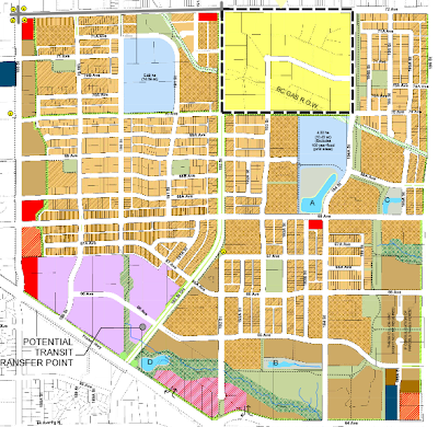
General land-use map of East Clayton. Click image to download PDF version.

While on the bus, I noticed that there is a new development that is being built at the corner of Fraser Highway and 64th Avenue. This area was originally to be a mixed-use, live/work area, but it now going to be a strip mall.

Rendering of Mosaic Clayton Market at Fraser Highway and 192nd Street/64th Avenue. Note that parking is not to scale.

Site plan for Mosaic Clayton Market at Fraser Highway and 192nd Street/64th Avenue. Click image to enlarge.

As you can see from the site plan, the project does a far better job of being pedestrian-friendly than the current strip malls in East Clayton, but I believe its design could have been improved. The project puts its best face forward on its internal road; it does not prioritize pedestrian access on Fraser Highway, its green lane, or 192nd Street. The biggest issue though is that a large drive-thru will be built between the future residential area and the commercial area. If the vision of East Clayton is to be pedestrian-friendly, drive-thrus should not be allowed. The drive-thru signals that the mall is an auto-oriented area.

I have to give the City of Surrey credit for not allowing the future office area to be developed into a strip mall, but I have to wonder why they have compromised the vision of East Clayton by allowing auto-oriented retail development in a community that was meant to be pedestrian-oriented.

Wednesday, November 27, 2013

Making better use of surface parking lots and vacant lots

One of the basic requirements to create a walkable high street is to have shops, restaurants, and cafes that go right up to the edge of the sidewalk. White Rock, Downtown Langley, and Fort Langley are some of the walkable places in the South of Fraser, and all have this basic design. A surefire way to kill walkability is to break up these pedestrian-oriented streets with surface parking lots and vacant lots.

Downtown Langley and Fort Langley both have surface parking lots and vacant lots that reduce the walkability of these areas. In fact, the City of Langley basically razed a complete section of its downtown over the last few years, replacing it with surface parking and ugly blue fencing. While these areas will hopefully be developed into buildings that enhance the pedestrian realm, right now they are destroy it. What if there was something that could be done in the interim to make these places contribute to creating a walkable community.

Asphalt Alley - City of Langley's Civic Centre

Portland, OR has its share of surface parking lots in both its core and older walkable neighbourhoods. The last time I was in Portland years ago, many of these places were under-underutilized and created dead zones. Last week when I was back, I noticed that many of these surface parking lots had temporary, permanent food carts at the sidewalk’s edge. Seeing how successful this concept was in bring livelihood back to the street, it would be good to try this in places like Downtown Langley and other location where there is underutilized space and dead zones.

Food carts; an intern-use at the edge of a surface parking lots in Portland. Source: http://www.flickr.com/photos/johnjoh/

These are interim uses that would be replaced when economic makes sense to build mixed-use building with ground level shops and services. The concept could also be extended to pop-up retail as well. This would certainly do more to improve places like Langley City than community killing surface parking lots. The City of Portland has a website about their food cart program and a guide called “No Vacancy! is an exploration of temporary use of vacant space” which contains information about this program.

Tuesday, November 26, 2013

My trip to Portland: comparing Portland to Metro Vancouver

Last Thursday, I took Amtrak down to visit Portland for a mini-holiday. I hadn’t been to Portland for about five years, so it was interesting to see what has change in the region and what has not. Portland is known for its investment in public transit and as being a multi-modal transportation leader with its bike, transit, and pedestrian-friendly communities. While Portland's core (circled by Interstate 5 and 405) contains some of the most walkable communities in North America, outside of the core things are a different story.

According to the latest National Household Survey for the City of Vancouver, 30% of all trips to work are made by public transit with 52% of trips to work by car. In the City of Surrey, 13% of all trips to work are made by public transit with 83% of all trips to work by car.

Like Metro Vancouver, Metro Portland contains multiply municipalities. According to the 2012 American Community Survey 1-year estimates in the City of Portland, 11.1% of all trips to work are made by public transit with 66.8% of all trip to work by car. In Vancouver, Washington (which is similar to Surrey), 4% of all trips to work are made by public transit with 88% of all trips to work by car.

Why is Portland with its investment in biking, transit, and walking more auto-dependant than Metro Vancouver?

Transportation infrastructure combined with land-use choices shape the accessibility of a community. No more clearly is this required combination more evident than in Portland. The Pearl District, which is part of central core of Portland, was transformed into a walkable community by combining mid-rise, mixed-use development with a streetcar network.

While I was taking the MAX light rail system in Portland, I was surprised at how the vast majority of station stops where still in low-density, auto-oriented areas. In Metro Vancouver, higher-density mixed-use communities are built around major transit stations and corridors. I did not notice this in Portland. For example, the low-density, auto-oriented neighbourhoods that the MAX Yellow line goes through have changed very little since the line was opened about a decade ago.

There could be several reasons for this. Local and regional government policies and politicians which guide land-use might need to be changed. There could also be community opposition to change. Social-economic factors also plan their part, but I think there is also another issue at play in Portland.

Metro Portland's frequency transit network. Includes TriMet buses and MAX light rail. Click image to enlarge.

In Metro Vancouver, the SkyTrain runs every 2 to 10 minutes depending on the time of day. Metro Vancouver also has an extensive frequency bus network that run 15 minutes or better service 7 days a week. In Portland, MAX lines run about every 10 minutes during peak weekday period, but you can wait 20 to 30 minutes for a train outside of the peak periods. The frequent bus network also only provides services every 20 minutes outside of peak periods and isn’t as extensive as TransLink's network in Metro Vancouver. I found myself having to look at the MAX light rail schedule this weekend when planning my trips. For a rapid transit system, this is not a good thing.

Portland has similar funding challenges as Vancouver. More service is needed, but money is not available. While Portland’s transit network may be underfunded today, it has a light rail grid that stretches out to almost all parts of the region. When Portland solves its funding challenges, it will be able to ramp up service. It seems to me the biggest challenge for Metro Portland will be to export the walkability found in its central core to other parts of its region; something we’ve done a better job of in Metro Vancouver.

Thursday, November 21, 2013

Metro Vancouver and the ALR

Last week, I posted about how critical the Agricultural Land Reserve is for the long term success of our region. I also posted about how the Provincial government is looking at dismantling the Agricultural Land Commission which would have a disastrous effect on sustainability in our region and the rest of the province. It appears that Metro Vancouver feels the same way. I thought I’d share some quotes from their latest Regional Planning and Agriculture Committee Meeting.

The ALC is a critical partner for implementing Metro Vancouver’s Regional Growth Strategy (RGS) “Metro Vancouver 2040 Shaping our Future”, adopted by the Board on July 29, 2011. The RGS explicitly states the importance of protecting the supply of agricultural land and promoting agricultural viability in collaboration with the Province and the ALC. The policy to maintain the Urban Containment Boundary not only helps to concentrate growth in urban areas, but also provides predictability and efficient use of financial investments in utility, road and transit infrastructure. In addition, lands designated for agriculture are essential for agriculture economic development, food security, as well as the future well-being of residents.

[The Regional Planning and Agriculture Committee recommends] that the Board request that the Minister Responsible for Core Review and the Minister of Agriculture:
a) ensure the Provincial Core Review process protects and enhances the Agricultural Land Reserve and Agricultural Land Commission (ALC) in support of mutual objectives to protect the region’s supply of agricultural land and promote agricultural viability;
b) reconfirm the Provincial 2013 budget commitment to provide the ALC an additional $4 million over three years to support the ALC in providing better oversight over the Agricultural Land Reserve including working with local governments to encourage farming; and
c) ensure adequate consultation opportunities for the Metro Vancouver Board and all local governments in the region.