
One of the key tenets of land-use planning in Metro Vancouver is to preserve green space, whether it be parks and areas with sensitive ecosystems, or farmland. To accomplish this, our region has an urban containment boundary in which all urban development is supposed to occur. There are policies in place, agreed to by all municipalities in our region, that create a higher barrier to sprawl outside of the urban containment boundary.
 |
| Urban Containment Boundary and General Urban Areas Map. Select map to enlarge. Source: Metro Vancouver |
Has our region done a good job of protecting green space? The answer would be a qualified yes. The following table shows the change in land-use mix in Metro Vancouver.
| Proportion of Overall Land Area in 2011 | Proportion of Overall Land Area as of August 2018 | |
|---|---|---|
| Agricultural | 19.8% | 19.7% |
| Conservation & Recreation | 47.1% | 47.4% |
| Industrial | 3.6% | 3.6% |
| Mixed Employment | 1.2% | 1.2% |
| Rural | 3.1% | 3.1% |
| General Urban | 25.2% | 25.1% |
There has been a small reduction in both land available for urban development and agricultural land, and a small increase in protected green space (parks and conservation). The following table from the October 5th Metro Vancouver Regional Planning Committee agenda shows how regional land-use designations have shifted over the last seven years.
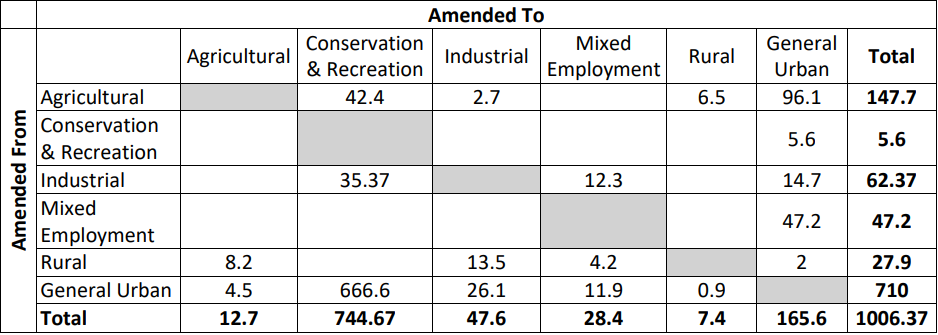 |
| Cumulative Changes in Regional Land Use Designation Amendments 2011 to August 2018. As a result of mapping clean-up through RCS, 0.3 hectares changed from undesignated to Conservation & Recreation, and 5.3 hectares changed from undesignated to Industrial. Select table to enlarge. Source: Metro Vancouver |
Communities like Langley City have been long built-out, and all our growth comes from redevelopment. While this is the story for pretty much all municipalities in Metro Vancouver, there are still significant areas of greenfield land available in the following municipalities:
| Municipality | Hectares | Percentage of Total Greenfield Land in Region |
|---|---|---|
| Langley Township | 1,910 | 32% |
| Surrey | 1,850 | 31% |
| Maple Ridge | 1,330 | 22% |
| Coquitlam | 680 | 11% |
Greenfield land includes undeveloped land, former suburban land, and former rural land.
Over the last 7 years, the Metro Vancouver Regional District and its municipalities have done a reasonably good job of preserving green space. With continued pressure to transform the most productive farmland in our province into sprawl, we will need to be vigilant to ensure that population growth occurs in already built-up areas or in the 5,770 hectares of greenfield areas.
No comments:
Post a Comment