Showing posts sorted by relevance for query vision zero. Sort by date Show all posts

Thursday, January 3, 2019

How to design roads that reduce fatalities and serious injuries in Langley City

Yesterday, I posted about how motor vehicle collisions are a leading cause of preventable deaths and injuries in our province. When over 21,000 people, a mid-size city’s population, who use our road network are being injured each and every year, we can’t continue doing business as usual when it comes to the design of our road network.

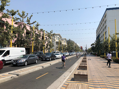
Shared space for people walking, cycling, and driving in Gastown. Select image to enlarge.

In Sweden, they decided to change how they design their roads. They adopted Vision Zero in 1997 with the statement that “it can never be ethically acceptable that people are killed or seriously injured when moving within the road transportation system.”

There are three major principles of Vision Zero:

  1. The designers of the system are always ultimately responsible for the design, operation and use of the road transport system and thereby responsible for the level of safety within the entire system.
  2. Road users are responsible for following the rules for using the road transport system set by the system designers.
  3. If road users fail to obey these rules due to lack of knowledge, acceptance or ability, or if injuries occur, the system designers are required to take necessary further steps to counteract people being killed or seriously injured.

Vision Zero sets the following safe speed limits:

  • If people walking or cycling, and motor vehicles share the same space (including at intersections and crosswalks), the speed limit should not exceed 30km/h. The road design should encourage people to travel 30km/h or slower.
  • If there is a possibility of side impact between only motor vehicles at an intersection, the speed limit should not exceed 50km/h, and the road design should encourage people to travel at 50km/h or slower through the intersection.
  • If there is a possibility of frontal impact only between motor vehicles, the speed limit should not exceed 70km/h, and the road design should encourage people to not travel faster than 70km/h.

The only time that speeds can be faster than 70km/h would be when there is zero chance of side or frontal impacts between motor vehicles, and zero chance of impacting a person walking or cycling. This would be for limited-access freeways.

Langley City is responsible for the local road network in our community. What does Vision Zero look like for our community?

A good example of Vision Zero in action would be 203rd Street between Grade Crescent and the Langley Mall. The intersection at 203rd Street and 53rd Avenue is a roundabout. That roundabout encourages motor vehicle speeds of around 30km/h. This makes it safe for people driving, walking, and cycling. At crosswalks, the road is narrowed which encourages people to drive slower. People walking and cycling are also separated from motor vehicle traffic outside of intersections which is why the speed limit can be higher than 30km/h, and still be compatible with the principles of Vision Zero.

The Fraser Highway One-Way is another example of a road that follows the principles of Vision Zero as its speed limit and design results in people driving 30km/h or slower.

A safer crosswalk at 54th Avenue and 204th Street in Langley City. Select image to enlarge.

An example of a road in Langley City that doesn’t follow the principles of Vision Zero is 208th Street. While the posted speed limit is 50km/h, people exceed 50km/h regularly. People do not drive at 30km/h through intersections or at crosswalks. People cycling are not separated from motor vehicle traffic.

Could a road like 208th Street become a Vision Zero road? It could if certain design elements where implemented. The first would be to ensure that people cycling are separated from motor vehicle traffic (like on 203rd Street). Ideally, the intersections with traffic lights would be replaced with roundabouts. If that is not possible, the traffic lights could be set to allow people walking and cycling to start crossing the road while all other traffic has a red light. Before the crosswalks, design measures could be put in place to ensure that motor vehicle traffic is traveling at 30km/h while passing through the crosswalk area.

Due to its success in saving lives and reducing serious injuries, Vision Zero has been implemented in many places, and is slowly making its way into policies of cities, provinces, and states in North America. Our province has released a guide about moving towards Vision Zero which also includes some case studies from throughout the province.

While enforcement is an important component of Vision Zero, it is impossible to have universal traffic enforcement. If enforcement was all that was needed, we would not have 21,000 people being injured due to motor vehicles crashes in 2017. We need to design roads that naturally cause people to travel at safe speeds; this is the third principles of Vision Zero. If a road has a 50km/h speed limit, but has a traffic flow of 70km/h, the problem is with the road design, not enforcement.

Monday, August 26, 2019

Visions Zero: Lessons from Sweden. Building safer roads and intersections.

I just got back from a holiday in Sweden where I visited at handful of mid-sized cities. While taking a holiday was the number one priority of the trip, I also was interested in seeing how Sweden designs safer streets. Motor vehicle crashes are the leading cost of deaths and injuries here in BC and in Sweden.

In 1997, the Swedes decided to do something about this and launched Vision Zero. Vision Zero, in short, looks to change the design of roads to make them safer. The data shows that this has been working in Sweden to reduce deaths and injuries from motor vehicle crashes.

These principles have been adopted in other places either formally or informally. In Langley City, we have a good example of a street that follows the principles of Vision Zero, 203rd Street. It has seen a reduction of crashes since it was redesigned.

I wanted to share a few pictures from my trip which shows Vision Zero in action. Because Langley contains both urban and rural streets, I will show an example of both.

For higher speed roads where there is a high volume of traffic, centre barriers are used in Sweden. Even if it is a two-lane road.

An example of a rural road with a passing section. Note the centre barrier. Select image to enlarge.

If 16th Avenue was in Sweden, it would have a centre barrier like in the preceding picture. Sweden is a rural country, so they rely heavily on road design to keep their roads safe.

There is also a large stationary photoradar network in Sweden. I saw speed cameras everywhere in rural areas at speed transition areas.

In urban areas, the normal speed limit on major roads is either 40km/h or 60km/h in Sweden. In the Langley City context, Fraser Highway between 200th Street and Glover Road would be 40km/h. The Langley Bypass would be 60km/h. Side streets and downtown areas are 30km/h.

While speed bumps are the preferred traffic calming measure in North America, they are not in Sweden. Swedes use road narrowing and pinch points to slow traffic down. Unlike speed bumps which can cause people to slow to a crawl at the bump, and speed up between the bumps, road narrowing and pinch points cause people to drive at a consistent slower speed.

An example of an intersection in Stockholm. Notice there are no stop signs.

An example of a crosswalk. Note the centre island. Select image to enlarge.

Intersections are the most dangerous points of any road. Roundabouts are the safest form of intersection. Whether a four-lane or two-lane road, roundabouts are the preferred form of intersection in Sweden. Traffic signalled intersections are the least preferred form of intersection there. I only saw traffic signals when there were space constraints that prevented the installation of a roundabout such as in historic areas. The 203rd Street roundabout in Langley is typical of roundabout design in Sweden.

An example of an intersection with a roundabout. Select image to enlarge.

In Langley City, we have good examples of how to build roads that follow Vision Zero principles. Today, these are the exceptions and not the default.

Sweden has had a 20-year head start working on creating Vision Zero streets, and they started in the same place we are today. I’m hopefully that we will be able to make Vision Zero the default design in our community, and not the exception over time.

Wednesday, February 20, 2019

Creating safer streets in Langley City. 80% drop in crashes on 203 Street.

The majority of streets in Metro Vancouver have been built and are maintained by municipalities. As I posted about in early January, motor vehicle crashes are a leading cause of fatalities in our province and a leading cause of hospitalizations. These statistics are alarming and unacceptable. These statistics are unacceptable because street design is directly linked to both the severity and number of crashes. Street design can be changed.

Many municipalities in North America are adopting “Vision Zero” principles to reduce the severity of injuries from crashes and to eliminate fatalities caused by motor vehicle crashes.

While Langley City has not official adopted Vision Zero principles, the City has nonetheless being making changes to our street network to reduce speeding and conflicts at intersections which help to reduce the frequency and severity of collisions.

Over the past several years, there has been a significant redesign of two streets in our community that have been completed to improve safety for all street users: 203rd Street and 53/51B Avenue, east of 204th Street.

Have these street redesigns been successful in creating safer streets?

203rd Street at 53A Avenue. Select image to enlarge.

Between the beginning of April 2016 and end of March 2017, there were 12 collision on 203rd Street between Michaud Crescent and Grade Crescent according to RCMP data. Between the beginning of April 2017 and end of March 2018, there were 2.

Between the beginning of February 2017 and end of January 2018, there were 4 collisions on 53/51B Avenue between from 204 and 208 Street. Between the beginning of February 2018 and end of January 2019, there were 2.

There have also been various smaller traffic calming projects implemented throughout Langley City in the past few years. Headlines were made in 2017 when there were several vehicles that crashed and flipped along 50 Avenue near Condor Park.

Before traffic calming was installed along this section of 50 Avenue, there were 4 collisions between the beginning November 2016 and the end of October 2017. Between the beginning of November 2017 and end of October 2018, there was 1 collision.

Most of the changes that have been made to Langley City streets in the last several years seem to be reducing the number of collisions. The means safer streets which results in a happier and healthier community.

Monday, May 10, 2021

Spring Metro Vancouver Council of Councils Meeting: Budgets, Metro 2050 Regional Growth Strategy, TransLink’s Transport 2050 Strategy

Twice a year, elected local representatives gather for a Metro Vancouver Regional District Council of Councils meeting. During the meeting, we hear updates from regional district staff and have the opportunity to ask questions of regional district staff.

On Saturday, around 120 local representatives attended a Zoom meeting.

I virtually attended Saturday’s Metro Vancouver Council of Councils meeting.

Regional district staff noted that the 2021 operation budget is $939.5 million, with the loin’s share of expense for water and liquid waste services. The capital budget for 2021 is $1.5 billion, funding significant wastewater treatment plant new-builds and renewals. The capital budget is funding by a combination of operation budget contributions, developer charges, and debt.

Staff also noted that they are continually looking to find new revenue streams and cost-saving opportunities. For example, they said selling natural gas as a byproduction of liquid waste management is a new revenue stream.

Metro Vancouver’s Climate Action Committee chair presented roadmaps for our region to become carbon neutral by 2050. One of the direct actions that municipalities can take is to adopt higher steps of the BC Energy Step Code. Metro Vancouver will encourage all municipalities to adopt Step 4 or 5.

I posted the transportation and housing updates for Metro 2050, the region’s proposed updated new regional growth strategy, last week. Regional district staff highlighted Metro 2050, including:

  • Creating a compact urban area
  • Strengthening the Urban Contain Boundary by focusing growth in urban centres and transit corridors
  • Protecting industrial land, local food production, and food security
  • Protecting conservation and recreation land
  • Protecting, restoring, and connecting ecosystems throughout the region by ensuring 50% of the region is natural areas
  • Reducing GHG emissions through land-use and settlement patterns.
  • Expanding the variety and supply of housing
  • Increasing affordable housing with a focus on affordable housing near transit
  • Supporting sustainable transportation choices like walking, cycling, and transit

Metro Vancouver staff stated that housing affordability is still the most significant concern among elected officials.

TransLink is also working on Transport 2050, which is the region’s transportation strategy. TransLink and Metro Vancouver staff are coordinating both Metro 2050 and Transport 2050.

The goals of Transport 2050 are to increase convenient, reliable, affordable, safe & comfortable, and carbon-free transportation options.

The plan has the following goals:

  • People take 50% of all trips by walking, cycling, or transit
  • People spend 20% less time stuck in congestion compared to 2019
  • People spend no more than 45% of their income on housing and transportation
  • There are no serious traffic injuries or fatalities, with reductions every year
  • By 2030, transportation-related GHG emissions will be cut in half and be zero in 2050

TransLink is making a big push for Vision Zero and slower streets in Transport 2050. TransLink staff also noted that they are looking at interregional rail to Squamish and the Fraser Valley in Transport 2050.

On autonomous vehicles, TransLink will be pushing a car-sharing model; otherwise, if we all own autonomous vehicles, there will be a massive increase in congestion.

Metro Vancouver staff noted that they are improving public notification and alerting around the Cleveland Dam and the Capilano River.

Wednesday, February 16, 2022

Transport 2050: TransLink’s New Long-Range Plan to Reduce Pedestrian and Cyclist Deaths

When people think of TransLink, they think about transit. While providing transit is the largest service that TransLink delivers, it also funds the major road network such as 200th Street as well as cycling and walking infrastructure such as 203rd Street, Duncan Way, Glover Road, and the 208th Street Causeway.

TransLink’s Board and the Mayors’ Council recently adopted Transport 2050, the new long-range plan for how we get around in our region. Transport 2050 works together with Metro 2050, the proposed new regional land-use strategy for Metro Vancouver.

I want to focus on aspects of Transport 2050 beyond transit.

Motor vehicle crashes are the third leading cause of injury-related death in BC for people who are 15 or older. Speed is a leading factor in these deaths.

According to TransLink, annually “100 people are needlessly killed [by motor vehicle drivers] on Metro Vancouver streets — typically, 40 of whom were walking, biking, or rolling while they were struck and killed.”

Strategy 4.1 of Transport 2050 is to eliminate traffic fatalities and serious injuries. This strategy is known as Vision Zero.

A people-first street in Santa Monica, California

TransLink plans to work with municipalities to accomplish this by:

  • Reducing the default speed limits and designing urban streets to 30 km/hr or slower, only supporting speed limits of 60km/h or more for controlled-access highways.
  • Allowing 50km/h speed limits as long as streets have signalized crossings, wide sidewalks, protected bike lanes, and transit priority lanes.
  • Transforming roads into people-first streets by creating safe and inviting environments for people who are rolling, walking, and cycling.
  • Providing support for other ways of getting around on people-first streets such as e-scooters, mopeds, and even delivery trikes.

Transport 2050 includes actions around enforcement and education such as:

  • Delivering, in partnership with other agencies, increased training on how to operate motor vehicles safely around people walking, rolling, cycling as well as around transit vehicles, heavy commercial vehicles and agricultural equipment.
  • Working with the police to focus traffic enforcement on dangerous motor vehicle drivers.
  • Working with the province to increase automated speed and traffic enforcement at high-collision intersections.
  • Working with the Commercial Vehicle Safety Enforcement branch to create a unified regional program of commercial vehicle safety inspections.
  • Working to encourage Advanced Driver Assistance Systems that help reduce collisions between drivers of heavy commercial vehicles and people walking, rolling, and cycling.

For more information, please read Transport 2050 starting on page 83 (number 163 in the strategy.)

Thursday, May 9, 2019

Top 10 vehicle crash intersections in Langley City have a few things in common

One of the comments that I receive regularly from people in Langley City when it comes to traffic safety is the request to install traffic lights and four-way stops to increase safety. I also received comments from people telling me that they believe that building narrower streets, tighter intersections, and roundabouts decrease the safety of Langley City streets. One the surface, this makes sense. The more uncomfortable a road feels to drive and the less certainty of who has the right of way, the more unsafe the road should be, right?

The following list from the most recent 2017 ICBC data shows intersections with the highest number of crashes that involve motor vehicles in Langley City.

Intersection Crashes
Langley Bypass @ Fraser Highway 130
Langley Bypass @ 200th Street 112
Langley Bypass @ 56th Avenue 77
200 Street @ Fraser Highway 67
Langley Bypass @ Glover Road 55
Langley Bypass/208th @ Fraser Highway 52
Langley Bypass 204th Street Turn Lane 34
Fraser Highway @ Glover Road 31
200 Street @ Logan Avenue 24
203rd Street @ 56 Avenue 23

There are some common design elements of these intersections. They have higher traffic volumes, traffic lights, higher speeds, and turn lanes. When driving through one of these intersections, most people feel completely safe and 100% certain of who has the right of way.

Intersections of wide roads with traffic lights are dangerous because of human nature. The safer we feel, the more likely we are to act in an unsafe manner. For example, would you send a text message while driving down the Fraser Highway One-Way? How about when driving along Highway One?

A good example is 203rd Street, the regular intersection with traffic lights at 56th Avenue, Fraser Highway, and Logan Avenue have a higher number of crashes. The section of 203rd Street south of 56th Avenue is one of the safest sections of road in Langley City. Even with its higher traffic volume, it is designed in such a way that people feel less comfortable driving. When people feel less comfortable driving, they drive safer.

This intersection of 56th Avenue/Douglas Crescent and 203rd Street had 23 crashes in 2017.

This complex section of 203rd Street, just south of 56th Avenue up to and including the Langley Mall pedestrian signal had 1 crash in 2017.

One of the best ways to increase road safety is to get people to drive slower and more cautiously. For more information about this, please check out a post I wrote about Vision Zero which outlines how to reduce road transportation crashes and fatalities.

Just a note, I posted in the past about why a four-way stop is not a great tool for traffic calming or to increase safety.

Wednesday, April 3, 2019

More transit and clean energy vehicles, plus mobility pricing required to reduce climate change

As I posted about on Monday, greenhouse gas emissions from our buildings and transportation systems are responsible for about two-thirds of all greenhouse gas (GHG) emissions in Metro Vancouver. I previously posted about what can be done to reduce GHG emissions from residential buildings. Today, I’ll be posted about what can be done to reduce the 37% of GHG emissions that are caused by our transportation system.

As documented in a report in the Metro Vancouver Climate Action Committee’s most recent agenda, both the BC Liberals and BC NDP had/have plans to reduce GHG emissions. When the Liberals were in power, it was the B.C. Climate Leadership Plan. The current BC NDP/Greens plan is called the B.C. Clean Growth Strategy.

Both of these plans call for an increase in public transit, and as shown in the following graph, while the current TransLink 10-Year Vision is having an impact on reducing GHG emissions, more is needed to reduce emissions further.

Metro Vancouver Personal Transportation GHG emissions. Hashed red line shows impact of 10-Year Vision. Yellow line is where we need to be. Select chart to enlarge. Source: Metro Vancouver

Not only do we need to invest more into public transit, but we must also look at a whole host of options to reduce GHG emissions caused from transportation. The following list shows the policies supported by the Metro Vancouver Regional District that are in the current provincial strategy.

  • Zero emissions vehicle mandate that would require automakers to report on their sales in 2019, meet targets starting in 2020 for new vehicle sales (increasing annually to at least 10% in 2025 and 30% in 2030), and a possible ban on the sale of new gasoline and diesel light duty vehicles by 2040.
  • Continue incentives for the Clean Energy Vehicle Program until zero emissions vehicles make up 5% of all new light-duty vehicle sales.
  • Take measures to encourage charging station installations at businesses and other buildings.
  • Expand the Specialty Use Vehicle Incentive Program, which supports the purchase of clean heavy duty vehicles, buses, transport trucks, motorcycles, and heavy equipment.
  • Increase the stringency of the Low Carbon Fuel Standard by decreasing the average carbon intensity of fuels by 15% by 2030 compared to 2010 levels.
  • Continue to invest in transit and investment in clean transportation infrastructure that is inter-connected, providing easy access to clean options and reducing demand for vehicles.
  • Development of demand-management programs, which focus on finding ways to reduce traffic overall, so people ultimately drive less.

Mobility pricing has been shown to be an effective demand-management program to reduce congestion which reduces GHG emissions. A good examples of this is how removing tolling on the Port Mann Bridge caused an overnight increase in congestion and emissions.

While the current province strategy called for demand-management programs such as road pricing, it will be interesting to see if progress will actually be made.

Strategies are only helpful is they are implemented. I hope that the current provincial government makes significant progress in acting on reducing GHG emissions to preserve our communities and way of life.

Wednesday, January 31, 2024

Metro Vancouver Regional District Board Votes Against Reducing GHG Emissions in Large Buildings

Large Buildings

The Metro Vancouver Regional District is the only regional district in BC with the delegated authority to regulate air quality. The Regional District Board has also approved various climate change reduction and mitigation policies, including Climate 2050, the regional district's overall vision for climate change adoption and reduction.

The overall goal is to reduce greenhouse gas emissions to 45% of the 2010 level by 2030, with the region becoming carbon neutral by 2050.

Buildings are responsible for about a quarter of our region's total greenhouse gas emissions. Drilling down further, buildings over 25,000 sq. ft. are responsible for about a third of those emissions. Put another way, Regional District staff found that about 9,000 buildings in our region cause 9% of the total greenhouse gas emissions. This number is significant.

Consistent with Climate 2050 policies, Metro Vancouver Regional District staff recommended applying a regulatory approach to reduce GHG emissions in these large buildings.

At a high level, the proposed policy would start with large building owners reporting their building's greenhouse gas emissions starting in 2026. The regional district would then set limits for greenhouse gas emissions that would come into force starting in 2028 and would slowly reduce to zero by 2045. Building owners would have to pay a per tonne charge for greenhouse gas emissions caused by fossil fuels over the set limit. Cooking-related emissions and buildings connected to district energy systems would be exempt.

At its January 26th meeting, the Metro Vancouver Regional District Board was asked to support this proposal approach in principle, directing Regional District staff to continue the development of the regulatory framework, including continuing engagement with large building owners.

My understanding is that after a debate, the Regional District Board, in a tight vote, decided against this policy approach.

Langley City's Director, Paul Albrecht, supported reducing emissions from large buildings. I also support the proposed regulatory approach.

I am disappointed that while the Regional District Board approved the bold Climate 2050 vision, it has elected to refrain from taking action within its jurisdiction. I hope there is a path forward, as reducing greenhouse gas emissions from large buildings will have a significant impact in helping our region meet its climate change mitigation goals.

Tuesday, December 18, 2018

Province’s new CleanBC plan promises new investments in walking and cycling

Earlier this month, the provincial government released its CleanBC plan. This plan outlines how the provincial government plans to reach its 2030 greenhouse gas emission (GHG) reduction targets.

One of the largest sources of GHGs is transportation. While the CleanBC plan outlines how the province plans to move towards a zero-emission future for automobiles, it also contains a section about the important role of active transportation in reducing GHGs and giving people a way on out congestion.

On page 25 of the report it states that “in 2019, the Province will establish an active transportation strategy with measures to support new infrastructure, education and incentive programs, and safety improvements for people walking, cycling and using other kinds of active transportation.”

The authors of the report note that currently the province invests just $1.50 per people on active transportation (walking and cycling), and that places like Denmark and New Zealand invest $34 and $24 per person respectively. The plan goes on to say that “lessons learned in these leading jurisdictions will help to inform the new B.C. strategy.”

Combined with the TransLink 10-Year Vision, significant funding is becoming available for walking and cycling infrastructure.

A family using the year-old bike lanes on 53rd Avenue this summer. Select image to enlarge.

In Langley City, we have been successful in getting grants from both TransLink and the provincial government to build cycling infrastructure on 203rd Street and 53rd Avenue. We also will be receiving funding from TransLink over the next few years to implement $1.9 million in cycling infrastructure on Glover Road and $2.2 million in cycling infrastructure on the 208th Street Causeway.

We’ve also received funding to improve walking in our community from TransLink for projects such as the new path on Duncan Way.

With the provincial government now doubling down on investing in active transportation options, Langley City will be in a good position to take advantage of that funding.

Our community is 10 square kilometres which is the perfect size for providing active transportation options. Within our community, if we continue to invest in safe and comfortable walk and cycling infrastructure, people will have real transportation choices. When traveling outside of our community, people will be able to take high-quality transit.

6% of people use active transportation options as their primary way to get to work in Langley City, and around 7% of people take transit to get to work, based on the latest 2016 census data.

While some people must use a car to get around, there is ample opportunity for increasing the number of cycling and walking trips in Langley City. Doubling the percentage of trips that use transit and active transportation options in our community would help reduce congestion and GHG emissions.