Thursday, August 29, 2019

An observation from Sweden: Independent mobility for people of all abilities is critical for a healthy community.

Over the past few days, I have been posting about my observations from being in a dozen or so small- to mid-sized cities in Sweden last week. When it comes to creating safe streets that reduce fatalities and injuries, and promoting walking and cycling, Sweden is ahead of us. There is one important caveat: you need to be able-bodied.

If you where a person with limited mobility requiring a chair or other aid, getting around cities in Sweden independently is challenging, and in many cases impossible. While many city centres in Sweden have been around since the 16th Century or earlier, the sidewalks and streets are modern.

Curb letdowns and smooth sidewalks are key ingredients to making an accessible community for everyone. The following are examples from Langley City.

An example of a modern sidewalk in Langley City. Select image to enlarge.

An example of an intersection in Langley City’s Downtown. Select image to enlarge.

In Sweden, I noticed that curb letdowns where generally wide enough for one bicycle, but not a wheelchair.

An example of a crosswalk in Sweden with a narrow curb letdown and a sidewalk with uneven pavers. Select image to enlarge.

I also noticed that they used a lot of pavers. While they are pretty, they are hard to navigate when using a mobility aid.

An example of a typical city square in Sweden with pavers. Select image to enlarge.

I noticed that people with limited mobility needed the help of friends or strangers to navigate in the places that I visited. While this might seem good, having to rely on other people to get around is not. As humans, we all need independence.

My observation about the lack of accessible access in most city centres in Sweden reminded me of the importance of making sure that we are building a community for all people in Langley City.

In Langley City, we have an accessibility representative on our Advisory Planning Commission which looks at all development proposals for our community. This is important because as an able-bodied person, there are things that I won’t get that someone with lived experience will be able to call out.

While there are many things that we can learn from Sweden about creating safer streets, we must not loose sight of the importance of building communities where people of all abilities can move around independently.

Wednesday, August 28, 2019

Treat walking and cycling the same way to create a safer, healthier community. Lessons from Sweden.

In BC, we tend to think of people riding bicycles in the same terms as people driving cars when it comes to the provisioning of transportation infrastructure, and the rules of the roads. In Sweden, they tend to think of people riding bicycles in the same terms as people walking. This mindset creates a very different experience for people riding a bike, and as a result, encourages more people to ride bikes for short trips around town.

In Sweden, people cycling and people walking are treated the same. Select image to enlarge.

In the dozen or so municipalities I visited in Sweden, ranging in size from White Rock to Abbotsford, I was surprised to see such a larger number and diversity of people riding bikes. I was especially surprised to see a larger number of seniors riding bicycles around town. There were also little kids riding bikes without parental supervision. Every demographic was represented riding bikes in Sweden.

This makes sense because the cycling infrastructure in Sweden is designed the same way as pedestrian infrastructure. While 203rd Street has some challenges with curb letdowns, it is close to what a typical major corridor looks like in Sweden. People ride bikes and walk across intersections the same way in Sweden. At roundabouts, people driving yield for people cycling and walking.

If 203rd Street was in Sweden, it would use the following sign at all crosswalks:

A pedestrian and cycling crosswalk in North Vancouver. Select image to enlarge.

Because residential side streets are 30km/h in Sweden, there is nothing special needed to make cycling safe on these streets.

One thing that I didn’t see was unprotected shoulder bike lanes in Sweden. This is the default design in BC because we tend to think of cycling like driving. Unfortunately, this kind of cycling infrastructure only attracts the spandex-wearing crowd. It makes cycling an unappealing option for most people.

203rd Street and the recently completed path on Duncan Way in Langley City is the kind of cycling infrastructure that is the default in Sweden for cities of all sizes. Because of this, cycling is an option that people of all abilities and ages take advantage of.

A shared-use path across a bridge in Sweden. A line in the path separates people walking and cycling. Select image to enlarge.

I’m happy that in Langley City, we are focusing on creating cycling infrastructure that is more in line with Sweden because what I saw in that country confirms that we are on the right path here.

Tuesday, August 27, 2019

The three Ps of a successful downtown: public parking, public transit, and pedestrian priority. Lessons from Sweden.

Last week, I was in Sweden on holiday. I visited close to a dozen small to mid-sized municipalities while there. One of the things that I noticed was that these municipalities all had vibrant downtowns; I observed some commonalities which contributed to their success.

Before I get into that, vibrant downtowns are important for many reasons. One reason is that they give a community an identity and sense of place. When you live in a community with this, you are more likely to be invested in its success whether it be by being involved with volunteering or by keeping your eyes and ears on the street which reduces negative activity.

Downtowns also support higher walking, cycling, and public transit usage. This create a healthy and happy community where people know their neighbours and have more positive health outcomes. It also supports reducing private automobile usage which reduces congestion, is good for the environment, and is good for human health.

Finally, downtowns are small-business incubators. Small-business owners invest more back into their communities of operation than businesses owned by larger national or international corporations.

I should also point out that Sweden, like Canada, has big-box stores and malls outside of their downtowns as well.

An example of a shared surface parking lot at the edge of a Downtown in Sweden. Select image to enlarge.

Shared parking is critical to creating a walkable downtown core. In Sweden, there was little to no private parking on the sites of shops and offices in their downtown cores. Instead, there was municipally-owned surface parking lots and/or parkades which book-ended the downtowns in Sweden. I was never more than a 10-minute walks from shared parking. There was on-street parking on some streets as well, but it was paid parking. Most of the shared parking was also paid parking, but it was cheaper than the on-street parking to encourage longer-term parking in the book-ended shared parking.

In North America, we generally require that all new buildings provide on-site parking. This is inefficient as it leads to more congestion and unnecessary parking spots. Here is a local Langley example.

If you visit Downtown Langley, you park once and walk to all the stores. If you are visiting the Langley Bypass, and need to go from Indigos to Sleep Country, you are likely going to drive from one store to the other because each on-site parking lots require that businesses be spaces further apart. This means for one shopping trip, you will need to two parking spots and need to drive which creates congestion.

Every downtown was also the home of the main transit exchange for each community in Sweden, this provides people an easy way to get to downtown other than by car.

Because of shared parking, public transit, and good walking and cycling access from residential neighbourhoods adjacent to downtowns in Sweden, they created people-first areas. The following picture shows a good example of this.

An example of a people-first Downtown in Sweden. Select image to enlarge.

This supports the creation of a strong and vibrant downtown.

Downtown Langley has many of the characteristics of downtowns in Sweden though it is missing the shared public parking. Interesting, our current zoning bylaw encourages building commercial areas more in line with the Langley Bypass than Downtown Langley. Langley City is in the process of updating our zoning bylaw. I will be supporting a zoning bylaw that creates a vibrant people-first community. I will also continue to advocate for a parkade in our downtown core.

Monday, August 26, 2019

Visions Zero: Lessons from Sweden. Building safer roads and intersections.

I just got back from a holiday in Sweden where I visited at handful of mid-sized cities. While taking a holiday was the number one priority of the trip, I also was interested in seeing how Sweden designs safer streets. Motor vehicle crashes are the leading cost of deaths and injuries here in BC and in Sweden.

In 1997, the Swedes decided to do something about this and launched Vision Zero. Vision Zero, in short, looks to change the design of roads to make them safer. The data shows that this has been working in Sweden to reduce deaths and injuries from motor vehicle crashes.

These principles have been adopted in other places either formally or informally. In Langley City, we have a good example of a street that follows the principles of Vision Zero, 203rd Street. It has seen a reduction of crashes since it was redesigned.

I wanted to share a few pictures from my trip which shows Vision Zero in action. Because Langley contains both urban and rural streets, I will show an example of both.

For higher speed roads where there is a high volume of traffic, centre barriers are used in Sweden. Even if it is a two-lane road.

An example of a rural road with a passing section. Note the centre barrier. Select image to enlarge.

If 16th Avenue was in Sweden, it would have a centre barrier like in the preceding picture. Sweden is a rural country, so they rely heavily on road design to keep their roads safe.

There is also a large stationary photoradar network in Sweden. I saw speed cameras everywhere in rural areas at speed transition areas.

In urban areas, the normal speed limit on major roads is either 40km/h or 60km/h in Sweden. In the Langley City context, Fraser Highway between 200th Street and Glover Road would be 40km/h. The Langley Bypass would be 60km/h. Side streets and downtown areas are 30km/h.

While speed bumps are the preferred traffic calming measure in North America, they are not in Sweden. Swedes use road narrowing and pinch points to slow traffic down. Unlike speed bumps which can cause people to slow to a crawl at the bump, and speed up between the bumps, road narrowing and pinch points cause people to drive at a consistent slower speed.

An example of an intersection in Stockholm. Notice there are no stop signs.

An example of a crosswalk. Note the centre island. Select image to enlarge.

Intersections are the most dangerous points of any road. Roundabouts are the safest form of intersection. Whether a four-lane or two-lane road, roundabouts are the preferred form of intersection in Sweden. Traffic signalled intersections are the least preferred form of intersection there. I only saw traffic signals when there were space constraints that prevented the installation of a roundabout such as in historic areas. The 203rd Street roundabout in Langley is typical of roundabout design in Sweden.

An example of an intersection with a roundabout. Select image to enlarge.

In Langley City, we have good examples of how to build roads that follow Vision Zero principles. Today, these are the exceptions and not the default.

Sweden has had a 20-year head start working on creating Vision Zero streets, and they started in the same place we are today. I’m hopefully that we will be able to make Vision Zero the default design in our community, and not the exception over time.

Thursday, August 15, 2019

Fraser Highway Express – Big Changes to Transit Start September 3rd

Thanks to the Mayors’ Council’s 10-Year Vision which is delivering a record-level of transit investments throughout Metro Vancouver, there will be some big improvements to transit along the Fraser Highway corridor.

Starting on September 3rd, there will be a significant enhancement to transit service along the Fraser Highway corridor from SkyTrain to Langley City (and onto Aldergrove).

Fraser Highway Express sign at Langley Centre Bus Loop.

The new Fraser Highway Express (503) is a limited stop service which is similar to TransLink’s new RapidBus network minus the fancy bus stops. Some bus trips will operate will longer articulated buses between SkyTrain and Langley City. Transit priority measures are also being rolled-out over the fall to keep the Fraser Highway Express on-time.

Fraser Highway Express Schedule:

Every 8 to 9 minutes during weekday peak periods
Every 10 to 15 minutes outside of peak periods
Every 30 minutes during the night

Fraser Highway Express Stops:

Surrey Central SkyTrain
King George SkyTrain
140th Street
148th Street
152nd Street
156th Street
160th Street
164th Street
168th Street
184th Street
188th Street
192nd Street
Willowbrook Mall
201a Street
Langley Centre

Map of service along Fraser Highway for 502 and Fraser Highway Express (503). Select map to enlarge.

The 503 becomes a local service route east of Langley Centre as it is today.

As a result, the 502 will see scheduling changes as well.

502 Schedule

Weekdays

Every 15 minutes in the early morning
Every 12 minutes during peak periods
Every 15 minutes outside of peak periods
Every 20 minutes during the night

Saturdays

Every 15 minutes 6am until midnight
Every 30 minutes from midnight until late

Sunday and Holidays

Every 15 minutes

In other Langley transit news, the 555 between Carvolth and Lougheed SkyTrain will started being served with double-decker buses starting in January 2020.

Wednesday, August 14, 2019

New housing needs report will help municipalities align zoning and better advocate for affordable housing for all

If you live in British Columbia, you are keenly aware that we are in a housing crisis. The housing crises might be the most keenly felt in Metro Vancouver where the price of housing whether apartment, townhouse, or detached house has skyrocketed. Even with the current damping of housing prices in our region, home ownership remaining unaffordable and unavailable for many people.

MLS Home Price Index Benchmark Prices for the Fraser Valley. Source: Fraser Valley Real Estate Board

The rental market has also seen prices escalated due to extremely low vacancy rates caused by a limited supply of new purpose-built rental units.

While the federal and provincial governments are now just starting to catch up, there was a multi-decade long under-investment in subsidized housing, specialized housing for people with physical and mental disabilities, and housing for people dealing with addiction.

In order to advocate for housing that meets the needs of all British Columbians, local governments need to know where there are gaps in the types of housing required within their community.

To help municipalities and regional districts, the provincial government enacted legislation last year to require that local governments complete housing needs reports. The specifics of what must be included in these reports was released this spring. The provincial government also provided funding to help local governments complete these reports.

Local governments must complete their first housing needs reports by April 2022, then update the reports every five years.

At at least 50 unique points of data must be incorporated into a housing needs report.

The Metro Vancouver Regional District already has expertise collecting demographic and housing data on our region. As the regional district is a federation of local governments, the district will be preparing the approximately 50 unique points of data for each local government within Metro Vancouver. This will save both time and money when creating the 20+ housing needs reports for municipalities in our region.

Local governments like Langley City would use the data from the Metro Vancouver Regional District to prepare their own housing needs report. The report must include:

  • Statements about key areas of local need, including affordable housing, rental housing, special needs housing, seniors housing, family housing, and shelters and housing for people at risk of homelessness
  • The number of housing units required to meet current and anticipated housing needs for at least the next five years, by housing type. Housing ‘type’ is defined as dwelling size (number of bedrooms)
  • The number and percentage of households in core housing need and extreme core housing need

These reports are required to be publicly available, and their content needs to be consider whenever there is an update to an official community plan (zoning) or regional growth strategy.

These reports will provide the information local governments need to advocate to the provincial and federal governments for funding to build subsidized and special needs housing.

It will also help keep local governments honest about the link between zoning and housing required in their community. If the housing needs report says a community needs 1-bedroom rental units, but current zoning only permits single-family housing, hopefully local governments will update their zoning to encourage 1-bedroom rental units.

I look forward to the development and release of Langley City’s housing needs report.

Tuesday, August 13, 2019

Massey Crossing Project Update: 6-lanes with bus-only lanes and keeping the old tunnel shortlisted.

Back in 2015, the provincial government which was controller by the BC Liberals announced that they were going to build a $3.5 billion, 10-lane bridge to replace the Massey Tunnel. I was concerned about this project. It would have caused worse congestion on the Alex Fraser Bridge. There were serious geotechnical challenges which likely would have escalated the cost of this bridge project further. The project also did very little to improve public transit.

When the NDP came to power, they paused the project to complete a technical review of it. The review which was released early this year stated that a 10-lane bridge was not required, and that a more modest design could be used.

The province is now moving forward with a rebooted George Massey Crossing Project. Unlike the first version of this project, there appears to be more consultation with local governments. Items that are important to municipalities in our region include enhancing transit, cycling, and walking transportation options. The new Massey Project is putting a priority on these modes of travel.

The project has a “commitment to transit growth; including dedicated [bus] lanes.” It will also include a 3.5 to 4 metre cycling and walking path on both sides of the road.

Options that are currently being considered include:

  • A new 6-lane bridge or tunnel with the existing tunnel being converted to a 2-lanes road for use by transit or local traffic
  • A new 8-lane bridge or tunnel with dedicated transit lanes

Building more than 3-lanes in one direction would simply shift congestion from one area to another. For a perfect case study, just look at the Port Mann Bridge and Highway 1. The modelling for the new Massey Project also shows that more lanes simple cause more traffic. This is called induced demand, and is a well know impact of highway expansion projects.

Updated George Massey Crossing traffic forecasts for 2035 and 2050 based on 4-lane, 6-lane, and 8-lane configuration. Select chart to enlarge.

The next step for the project is to further study the short-listed options to come up with a preferred option.

The lower the lane count, the less a river crossing project costs to build. I’m hopeful that the province will choose a cost-effective option to make sure that funding is available for other transportation project and to reduce the impact of induced demand.

Monday, August 12, 2019

Volunteers needed for 2nd Annual Know Your Neighbour Campaign

When people know their neighbours, we end up with a safer community. People who have connections with other people in their building, complex, or neighbourhood, even if it is just saying a simple hello to the person who lives across the street or hall, helps create a sense of ownership.

When people have a sense of ownership in their community, they are more likely to notice when something or someone is out of place. This helps reduce negative activity. Beyond creating a stronger and safer community, knowing your neighbour also makes people happier. For a good book about this, read “The Happy City.

To give people tools to connect with their neighbours, including services available from the city to support these connections such as Block Watch and funding for neighbourhood BBQs, the 2nd Annual Know Your Neighbour Campaign is scheduled to hit the streets on September 28 and October 5.

Last year’s campaign was a big success. To make this year’s campaign even more successful, your help is needed.

The Know Your Neighbour Campaign is an initiative of Langley City’s Crime Prevention Task Group. We need your help to go door-to-door for 2 hours either on Saturdays, September 28 and/or Saturday, October 5. The more people that volunteer, the more neighbourhoods we can visit.

I was handing out information in the Uplands neighbourhood during last year's campaign. Select image to enlarge.

I helped out last year; it was a lot of fun. To signup to volunteer, please contact Dave Selvage who is the Manager of Bylaw Enforcement at dselvage@langleycity.ca or 604-514-2822.

Thursday, August 8, 2019

RapidBus: Better B-Lines for Metro Vancouver coming this winter.

While rail rapid transit gets most of the attention in Metro Vancouver, it is the bus system that moves the majority of people who use transit in our region. As part of TransLink’s 10-Year Vision, significant investments are being made to bus service in our region. This includes investing in higher-quality bus service.

Most people in Metro Vancouver know that B-Lines are limited stop bus routes. Limiting the number of bus stops on a route increases the speed of a route.

Another key to speeding up bus service is to provide bus priority measures such as bus-only lanes and bus priority at intersections. Today’s B-Line routes have limited and inconsistent application of bus priority measures.

As it rains a lot in Metro Vancouver, bus shelters are important. Not all B-Line stops have shelters today.

As part of the 10-Year Vision, TransLink will be rolling out more and better B-Line routes.

Some of the meaningful enhancements compared to today’s B-Lines include consistent and targeted bus priority measures along routes, all-door boarding, and articulated buses. Bus stops will also be better as they will have real-time next-bus info and shelters at all stops.

An example of a RapidBus stop post. Select image to enlarge.

Because these routes will be better than B-Line today, TransLink is calling this service RapidBus. The following will be the new RapidBus routes which will be launching in January:

R1: King George Boulevard (Guildford Town Centre to Newton Exchange) – upgraded 96 B-Line
R2: Marine Drive (Park Royal to Phibbs Exchange)
R3: Lougheed Highway (Coquitlam Central Station to Haney Place)
R4: 41st Avenue (UBC to Joyce–Collingwood Station)
R5: Hastings (SFU to Burrard Station) – upgraded 95 B-Line

Bus service on these routes will run every 3 to 10 minutes in peak times, and 8 to 15 minutes at other times of the day. TransLink has posted information about these routes and RapidBus in general on their website.

The following maps show the transit priority measures being implemented on these routes.

R2 - Marine Drive: Map of Transit Priority Measures. Select map to enlarge.

R3 - Lougheed Highway: Map of Transit Priority Measures. Select map to enlarge.

R4 - 41st Avenue: Map of Transit Priority Measures. Select map to enlarge.

Fraser Highway between Langley City and Surrey Central was supposed to get RapidBus service too. Because of the extension of SkyTrain to Fleetwood, this was put on hold. Instead, this corridor will be getting RapidBus Lite service starting this fall. From what I can tell, the only meaningful difference is the lack of bus stop amenities such as real-time info and shelters at all stops. As I will be taking the new Fraser Highway service daily, I will be posting about my experience.

More RapidBus routes will be launched in Metro Vancouver beyond these five as the 10-Year Vision continues to roll out.

Wednesday, August 7, 2019

Local governments responsible for majority of infrastructure in BC, yet receive least revenue

Recently, the provincial government released its 2018-19 public accounts. This document is the annual financial report for the provincial government. The provincial government also collects financial information for regional districts and municipalities in our province. It has recently made this draft information available online for 2018.

The following pie chart shows the amount of revenue that the provincial government collected in 2018-19, and the total collected by regional districts and municipalities in our province in 2018.

This revenue also includes grants and transfers between governments. For example, the provincial government receives funding from the federal government, and local governments receive funding from both the federal and provincial governments.

As you can see, the provincial government receives the lion’s share of revenue in BC. This is not surprising.

While the provincial government provides important services to people such as health care, education, and social assistance, it is local governments (municipalities and regional districts) that operate services that require significant infrastructure such as water, sewer, roads, and parks.

The following chart shows that local governments are responsible for the majority of physical infrastructure in our province.

So why does this matter? There was a large investment in infrastructure that occurred in the mid-twentieth century. Most of this infrastructure is now coming due for replacement in the next decade or so. Given the limited amount of revenue that local governments collect, and the amount of infrastructure that needs to be renewed, we need to start talking about a New Deal for local governments in our province.

Either the federal and provincial governments have to increase their commitments to transfers and grants for local governments to fund infrastructure renewal, or the provincial government will need to enable new funding options such as expanding local government’s ability to collect developer charges, or new revenue steams such as a half-penny sales tax for local government.

I did not include the federal government in these charts as I do not have a breakdown of revenue collected from British Columbia by the feds, nor infrastructure directly owned by the feds in BC. I can say that the federal government owns less infrastructure in BC than the provincial government.

As a note, local government infrastructure value also includes land. These charts are interactive.

Tuesday, August 6, 2019

Learning about Metro Vancouver’s Regional Centres including in Langley

The idea that the Metro Vancouver Regional District should be made up of compact communities connected by high-quality transit has existed since the 1960s, becoming formalized in the mid-1990s under the Livable Region Strategic Plan (LRSP).

Under the LRSP, nodes of regional city centres were to accommodate the majority of new jobs and housing in our region. Because these regional city centres are relatively compact, concentrating jobs, shops, and housing into these areas creates walkable, bikeable, and generally accessible communities. This concentration makes it feasible to serve these centres with high-quality, frequent transit.

In 2011, these regional centres where further formalized into a hierarchy of regional city centres, municipal town centres, and frequent transit development areas.

Map of Regional City Centres, Municipal Town Centres, and Frequent Transit Development Areas. Select map to enlarge.

Regional City Centres are “major regional centres, serving Metro Vancouver’s subregions.” These centres are to be transit hubs.

Municipal Town Centres are “hubs of activity within municipalities.” These centres are to be connected via rapid transit or frequent transit.

Frequent Transit Development Areas (FTDA) are “focal areas for growth in alignment with TransLink’s Frequent Transit Network.”

Map of TransLink’s Frequent Transit Network. Select map to enlarge.

The Metro Vancouver Regional District has created an Urban Centre and FTDA Profiles Dashboard to help monitor the alignment of these centres in relationship to regional objectives such as concentrating jobs and employment into these areas, and transit connectivity.

Langley City and Township share a Regional City Centre. The Urban Centre and FTDA Profiles Dashboard provides a breakdown of statistics for this Regional City Centre by municipality.

Map of Langley Regional City Centre. Select map to enlarge.

For example in the Langley City portion of the Langley Regional Centre, there are 13,045 total jobs based on the 2016 census. That number is 8,650 in the Township portion.

The Langley Regional Centre is one of only two regional centres that isn’t served with rapid transit today. Building SkyTrain to Langley will fulfill a critical regional objective of connecting regional centres with high-quality transit. Even so, 8.5% of people that live in the Langley City portion of the Langley Regional Centre take transit to work as of the 2016 census.

To learn more about Metro Vancouver’s Urban Centres and FTDAs, please explore the regional district’s dashboards.

Thursday, August 1, 2019

The search for the meaning of “crescent” found in aerial photos of mid-20th century Langley City

Over the Canada Day long weekend, I posted a somewhat silly comment on Facebook noting that all roads called “crescent” in Langley City were not in fact crescents. A crescent is typically a road that connects a street to an avenue, or has two connections off the same road. The only “true” named crescent in Langley City is Brydon Crescent.

After I posted this comment, I started to wonder if these roads call “crescent” such as Eastleigh Crescent, Grade Crescent, Michaud Crescent, or Douglas Crescent where in fact true crescents at one point.

The provincial government has aerial photos that date back to at least 1936. Most of these photos are not online, so they need to be special ordered. I decided to special order some aerial photos from the time range between 1946 and 1953 around Langley City.

The following map shows what Downtown Langley City looked like in the early 1950s.

Aerial photo of mid-20th century Downtown Langley City with markup. Select image to enlarge.

The green line is 200th Street, the street marked with the heart is Michaud Crescent which ran south of the Interurban passenger and freight railway. The star denotes the beginning of the Fraser Highway One-Way which is marked in yellow. The lighting bolt marks the intersection of Douglas Crescent and 208th Street. If you look closely, you can also see Eastleigh Crescent.

Looking at this photo, it is clear that these roads were never crescents.

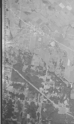
The next image shows all of Langley City in the same time period. The BC Hydro right-of-way is present in this photo. Grade Crescent, which used to be an old rail right-of-way, is also present.

Full aerial photo of mid-20th century Langley City. Select image to enlarge.

One of the other interesting things is that 208th Street used to go around a pond which is the current site of Nicomekl Park at 208th Street and Fraser Highway. It looks like when the 208th Street Causeway was built, the pond was drained. This is something that wouldn’t be allowed today.

As far as I can tell, the term “crescent” in Langley City really means original road.

As someone who values history, I was really happy to find out that the provincial government keeps historical aerial photos of our communities.