Wednesday, September 30, 2015

Langley City Council eyeing to reduce property tax exemption for some non-profits

Under BC law, local governments are not allowed to collect property tax from the land and buildings used by churches, cemeteries, mausoleums, and private schools that meet certain criteria. Land and buildings used by local, provincial, or federal governments, and land used by organizations owned by various levels of government are also generally exempt from taxation.

Local governments in BC are also allowed to exempt organizations from paying property tax within their jurisdiction for a limited period of time, though this period can be renewed indefinitely.

In the City of Langley, the following organization do not pay property tax because of a permissive tax exemption:

  • Global School Society
  • Governing Council of the Salvation Army
  • Ishtar Transition Housing
  • Langley Association for Community Living
  • Langley Care Society
  • Langley Community Music School
  • Langley Hospice Society
  • Langley Lawn Bowling
  • Langley Seniors Resource Society
  • Langley Stepping Stones
  • Langley Community Services
  • Southgate Christian Fellowship

The Langley Memorial Hospital Auxiliary was looking for Langley City Council to provide a tax exemption for their thrift store. The Langley Food Bank was also looking for a tax exemption. On Monday, Langley City Council voted against providing a tax exemption to these organizations.

Right now the City provides about $276,000 in permissive tax exemptions. This represent a 1.2% loss of property tax revenue.

Langley City Council on Monday voted to review the current permissive tax exemptions with an eye to reduce them.

While I understand Council reasons for looking to reduce these tax exemptions, there are many inconsistencies, I certainly wouldn’t want to see the Langley Seniors Resource Society having to start paying property tax; they provide a much needed service to the community.

This tax review may turn into a politically charged affair, as many of these non-profit organizations have members with deep roots in the community.

Tuesday, September 29, 2015

Confusion at City Hall about building safer bike lanes along 203rd Street

Last night, I attended the City of Langley’s Council meeting. The Parks and Environment Advisory Committee’s recommendation to build protected bike lanes along 203rd Street, as part of a larger 203rd Street reconstruction project, was before Council. Staff recommended that Council deferred their decision about whether to build protected bike lanes until costing could be determined, and until public support of protected bike lanes could be gauged.

While I agree that costing needs to be provided in order for Council to determine if they would like to support making our streets safer for all road users, I really have to wonder why building protecting bike lanes would even be considered an optional component on a major thoroughfare like 203rd Street.

Would building a sidewalk be something open for debate? I would certainly hope not.

There was confusion at last night’s Council meeting about the recommendation to building protected bike lanes along 203rd Street, and some of that confusion was caused by Francis Cheung who is the Chief Administrative Office of the City.

Mr. Cheung noted that the 2.5 meter multi-use pathways, that are being proposed for both sides of 203rd Street, are protected bike lanes. This led some on Council to question why further protection would be needed.

The 2.5 meter pathways are not protected bike lanes. Mixing cycling and walking into the same space can create conflicts between people who are walking at a slower speed, and people who are cycling at a faster speed.

Of course, there are many ways to create safe spaces for walking and cycling. For example instead of building on-street bike lanes, the 2.5 meter sidewalk could become a 4 meter sidewalks with a painted line to delineate space for walking and cycling.

Councillor Gayle Martin stated that she was “taken aback” by the Parks and Environment Advisory Committee’s recommendation, and didn’t want to see “Vancouver-style” bike lanes in Langley City. The Parks and Environment Committee was not recommending the construction of a two-way protect bike lanes like in Downtown Vancouver.

Councillor Albrecht and Councillor Hall were not in support of the deferral as they wanted to see protected bike lanes as part of the 203rd Street reconstruction project, full-stop. At the end of the discussion over the recommendation, Council voted to deferred voting on the inclusion of protected bike lanes until costing can be determined, and the public is consulted on the overall project.

I hope that City of Langley staff will come back with a reasonable, cost-effective option for Council to vote on that will make 203rd Street feel safe enough that people will allow their children to walk or bike along the corridor.

Monday, September 28, 2015

It’s a lack of money, not TransLink, which is preventing transit service expansion in Langley

From time-to-time citizens, business associations, and non-profit organizations in Langley propose various transit-style services to fill-in real or perceived gaps in the service provided by TransLink.

I know that many in Langley believe that TransLink doesn't care about our community, and the lack of transit service in many areas of Langley is a results of TransLink not caring.

The challenge with all these proposals is that the cost of providing these services are normally underestimated. It seems that the proponents of these independent transit services believe that all they need is a physical bus and volunteer labour; this is never the case.

For example, TransLink community shuttle service runs between $300,000 and $1,000,000 per year to operate per route with a basic 30-minute service frequency. A less frequent service would have very limited use.

One of the more recent attempts to start an independent transit service was the Aldergrove Shuttle. This service would have provided bus service around Downtown Aldergrove and Gloucester Industrial Estates. Gloucester Industrial Estates is a business park around the 264th Street Interchange that is completely surrounded by farmland. Because of the design and location of Gloucester, it is not a walkable or transit-friendly area.

The fact of the matter is that TransLink doesn’t run transit in areas like Gloucester today because it would serve only a handful of people per day. Transit service to this area would run at a huge loss. As TransLink has been told to be more efficient with its money, and with no new money available to expand service, areas like Gloucester will likely never see transit service.

Over the last few years, funding for HandyDart service which provides “door-to-door, shared ride service for passengers with physical or cognitive disabilities” has been reduced. Because of this reduced funding, service has suffered. It is no surprise that many organizations in Langley are now calling for the creation of a Langley-based shuttle service similar to HandyDart.

At the last afternoon Township of Langley meeting, Council referred the following motion to its Senior’s Advisory Committee based on a previous delegation to Council.

Whereas the Township of Langley is an Age Friendly Community;

Whereas transportation is one of the key elements of the Age Friendly Strategy; and

Whereas the draft implementation plan for the Age Friendly Strategy identifies the area of transportation as requiring further study and research;

Therefore be it resolved that the information provided by Ms. Reddington’s delegation be reviewed by staff for a report back to Council; and

Be it further resolved that this report include the exploration of a Seniors-Only Shuttle Bus for Greater Langley based on the survey results, which study would include consultation with seniors and senior-serving stakeholders as well as the business community.

Now assuming that the Senior’s Advisory Committee and Council decide to move forward with this proposal, will the Township of Langley, City of Langley, and other community organizations contribute funding to purchase the buses needed to run the service? Will these same organizations commit to spending the millions of dollars per year needed to operate the service?

Not to sound like a broken record, but the problem with transit service in our region is not TransLink. The problem with transit in our region is that there is simply not enough money to provide the services that people want.

While I certainly support more transit, paratransit, and custom transit service in Langley, no expansion will happen until the matter of funding can be resolved. Once funding is secured, regular and HadyDart service can be increased in Langley. No independent transit service will be needed.

Friday, September 25, 2015

UBCM resolutions show what challenges are top-of-mind for local governments

This week the annual UBCM conference is being held in Vancouver. The UBCM represents the interests of local governments in our province, and advocates on behalf of all local governments in BC.

Our province is unique in Canada in so far as the provincial government treats local governments as another order of government. Even though local governments are created by provincial legislation, there is a higher degree of respect from the province around the autonomy of local governments. In other provinces in Canada, provincial governments normally do as they please to local governments. For example, sections of the Greater Toronto Area were merged into one municipality on the whim of the Ontario provincial government in the 1990s.

At the UBCM, local government delegates propose and endorse a series of resolutions which they want the provincial government to address. The province responds to these resolutions several months after the convention. Sometimes the provincial government actually takes action on the resolutions passed, but most of the time it usually responds to the resolution with words that sound nice, but mean nothing.

For example, last year local governments asked that “the provincial government increase [and pay for] the number of RCMP members at detachments that have identified staff shortages through RCMP audit.”

The provincial response was “in these fiscally challenging times, it is increasingly imperative to find innovative solutions to meet public expectations for the delivery of police services and address increasing costs. Government has set this as a priority for the RCMP.”

Nice words, but little action. Another resolution last year called for the province to take action on adding regulations around e-cigarettes. The province indicated that it would take action, and now has, on this resolution.

This year, there are some 166 resolutions that are looking for an endorsement at this year’s UBCM conference.

One of the interesting resolutions endorsed this week is for the provincial government to allocate 60% of the revenue it receives from the federal “New Build Canada Fund” directly to local governments. Right now, the province only redistributes 40% of the funding it receives from the feds to local government for infrastructure, pocketing the rest. Local governments have the largest pool of infrastructure assets in BC, but collect the least about of taxes compared to the provincial and federal governments.

Another resolution that was endorsed this week called for the province to enact an Environment Bill of Rights which:

  • Recognizes the right of every resident to live in a healthy environment, including the right to clean air, clean water, clean food and vibrant ecosystems;
  • Provides for public participation in decision making respecting the environment and access to environmental information;
  • Provides access to justice when environmental rights are infringed; and
  • has whistle-blower protection.

As you might imagine, local governments in BC haven’t been impressed with the scandal-laden provincial Auditor General for Local Government. Many in local government saw the creation of this position as a way for the province to start micro-managing local governments, while providing little benefit to local governments. It is no surprise that a resolution was passed to eliminate the AGLG position.

Some other interesting resolutions relating to public transit include a resolution from Vanderhoof requesting that the province fund public transit delivery in rural and resource-based communities. Since the provincial government has stop funding transit expansion via BC Transit starting this year, another resolution by Lower Mainland Local Government Association is asking that the provincial government once again invest in public transit expansion throughout the province.

Another thing that local governments have been requesting of the provincial government for a few years now is for more flexibility to reduce speed limits in urban areas from 50km/h to 40km/h. By reduce speed-limits, lives are saved. Unfortunately, the provincial government has been raising speed limits because it is politically popular. In rural areas, the speed limits on some roads have increased from 80km/h to 100km/h. The Central Okanagan Regional District proposed a resolution for the province to put in place a formalized process where local governments can request a lowering of the speed limit on certain sections of highways that pass through rural communities and neighbourhoods.

While most of the resolutions don’t actually result in any action by the provincial government, reading the resolutions endorsed is a good gauge of the challenges that local governments in BC face.

Wednesday, September 23, 2015

The High Cost of 208th Street Expansion

If you talk to anyone who lives in Willoughby or Walnut Grove, they’ll likely tell you that 208th Street is a mess. 208th Street varies between 2 and 4 lanes. During peak periods, the whole corridor between Costco and the 208th Street Overpass is congested.

During last fall’s municipal election, promises were made to speed up the expansion of the 208th Street corridor. As it turns out, these promises will be costly.

If you travel along 208th Street, you’ll know that some sections of the corridor are fully expanded while other sections are not. Up to this point, developers have paid for the full cost of expanding the corridor. This is why 208th Street is only fully expanded next to new development projects.

The current plan will see 208th Street fully expanded as development projects along the 208th Street corridor are completed.

Map of anticipated time-frame of development along 208th Corridor. Select map to enlarge.

Knowing that the expansion of the 208th corridor was a long-term project, Council looked at making the 208th corridor part of TransLink’s Major Road Network several years ago. This would have entitled the Township to TransLink cash to cover not only half the cost of maintaining the corridor, but also cash to help speed up the expansion of the corridor.

If 208th Street was part of the Major Road Network, it would have also made the Township eligible for TransLink cash to expand the 208th Street Overpass. Currently, the Township of Langley is planning to pay for the full $12.6 million cost of expanding the overpass directly out of its own pocket.

Township residents in the area opposed making 208th Street part of the Major Road Network because they feared that 208th Street would become a trucking highway. Of course this wouldn’t be the case, but Township Council scrapped this plan due to public pressure; the Township rejected cash from TransLink!

As part of the development process, the Township requires proponents of development projects along 208th Street to dedicate land, for free, for the expansion of 208th Street. If the Township continues to build out 208th Street as development proceeds, it would cost about $29.7 million.

If Township Council decided to speed up the process, it would cost an additional $16.7 million as the Township would have to pay for the cost of land acquisition needed to expand the corridor.

While speeding up the expansion of the entire 208th Street corridor might seem like a good idea today, in the long term it will cost Township taxpayers more. While developers will eventually pay for most of the cost of expanding 208th Street through developer cost charges, the higher cost of speeding up the expansion will mean that there will be less developer money available to pay for things such as parks and community centres.

Rejecting TransLink cash and speeding up the expansion of the 208th Street corridor will end up costing Township taxpayers tens of millions of dollars. Is that cost worth it?

Tuesday, September 22, 2015

Metro Vancouver needs another transit study like I need a hole in the head

If there is one thing that we are good at in Metro Vancouver, it is putting together studies on transportation planning, regional transportation governance, and the interaction between land-use and transportation systems.

When funding isn’t available to accomplish what is needed, in Metro Vancouver, we do another study. The action of completing a studying makes it seem like we are moving forward, even if we are not.

Take transit for example, there is a broad consensus at the local level on what needs to happen. Metro Vancouver’s Regional Growth Strategy, the Mayors’ Council Transportation Vision, and TransLink’s Regional Transportation Strategy lay out what needs to happen to maintain the livability of our region and expand transit service. All these plans have been recently updated.

Another thing that we seems to be obsessed with is studying and changing the governance model for TransLink/regional transportation delivery. While regional growth and transportation plans do need to be updated from time-to-time, our region needs another TransLink governance study like I need a hole in the head.

Right after the majority of Metro Vancouver residents voted No to funding our transportation system with a 0.5% sales tax, the Metro Vancouver Board passed the following two resolutions:

That the GVRD Board direct staff to investigate options for Metro Vancouver to increase its role for advocacy and planning in transportation;

and

That the GVRD Board direct Metro Vancouver staff to work with the TransLink Mayors’ Council to prepare a report that investigates alternate governance structures for the delivery of public transit within the region including perpetuation of the current TransLink governance structure and a public utility model similar to the current water and liquid waste utilities.

This is yet another governance study on the delivery of regional transportation services in Metro Vancouver. The study that Metro Vancouver is starting to initiate will answer the following questions:

  1. How can transportation planning, operating and financing best be undertaken to achieve a wholly integrated land use and transportation plan and system?
  2. What are the characteristics of an effective and sustainable transportation system that we hope to achieve and/or optimize in the Metro Vancouver region
  3. What governance model can best allow land use planning to drive decisions about the transportation system? What role should key bodies (i.e., TransLink, Mayors’ Council, Metro Vancouver) play?
  4. In the short term, how can we optimize the transportation system within the governance structure as it currently exists?
  5. Over the longer term, what changes to the governance model help to achieve a broader range of characteristics of an effective and sustainable transportation system?

Honestly, we can study how to deliver a world-class transportation system six ways from Sunday, but the real issue in Metro Vancouver isn’t our regional plans, its funding those plans.

Until the provincial government and local governments in Metro Vancouver come to a consensus on how to fund transit and other regional transportation infrastructure, all the studying in the world will not cause more SkyTrain or light rail lines to be built.

Monday, September 21, 2015

Metro Vancouver's industrial land base is shrinking as demand rises

Just like the Agricultural Land Reserve which is meant to protect farmland from urban development, some organizations such as Metro Vancouver and Port Metro Vancouver have been calling for the creation of an Industrial Land Reserve.

Because Metro Vancouver is a popular place for people to live and businesses to grow, two things have happened. Former industrial sites have been converted to residential and office spaces because land is so valuable. At the same time, the remaining, shrinking industrial land base has been steadily filling up.

In fact, Metro Vancouver predicts that somewhere after 2024 all the industrially zoned land in the region will be developed.

Industrial land demand and supply, based on total industrial land capacity in 2010. Select table to enlarge.

One of the important things for industrial land users is proximity to major transportation infrastructure such as port facilities, railways, and highways.

To protect industrial land, Metro Vancouver introduced two regional land use designations as part of its Regional Growth Strategy. Industrial area are to be used for “heavy and light industrial activities, and appropriate accessory uses. Limited commercial uses that support industrial activities are appropriate. Residential uses are not intended.”

As Metro Vancouver is a federation of municipalities, during the creation of the Regional Growth Strategy, many municipalities did not like the restrictive nature of the regional Industrial land designation. In response, Metro Vancouver created a “Mixed Employment” designation. This designation allows for all land uses, but residential uses. Industrial factories, office parks, and big-box malls are permitted in “Mixed Employment” areas.

The following map shows the various regional zones.

Metro Vancouver's Regional Growth Strategy land use map. Select map to enlarge.

In 2010, Metro Vancouver completed an Industrial Land Inventory.

2010 Industrial Land Inventory. Select map to enlarge.

As you can see in the proceeding map, pretty much all of the regionally designated Industrial land is developed. The largest vacant areas that could be used for industrial uses are in Surrey, but these areas are regionally designated as the weaker “Mixed Employment” use.

With the shortage of industrial land in the region, municipalities such as Surrey need to have a hard look at whether they want to allow office parks and malls in “Mixed Employment” areas. The problem is that industrial land users in our region typically take up a lot of space, and don’t provide the same intensity of jobs or property taxes as other land users.

As industrial land fills up, there will be pressure to convert agricultural land to industrial land. This already happened within the Tsawwassen First Nations.

Does an Industrial Land Reserve make sense? This discussion will likely continue for many years to come. In the meantime, Metro Vancouver is working on updating its Industrial Land Inventory from 2010.

Thursday, September 17, 2015

Lack of transit service threatening Regional Growth Strategy

One of the key pieces of Metro Vancouver's Regional Growth Strategy is to accommodate 40% of new residential housing and 50% of employment growth within Urban Centres. The strategy also calls for 28% of residential and 27% of employment growth along frequent transit corridors. The map below shows both Urban Centres and current Frequent Transit Development Areas.

Map of Urban Centres, Frequent Transit Development Areas, and the Frequent Transit Network in Metro Vancouver. Select map to enlarge.

By concentrating growth in these areas, the pressure to develop in agricultural and rural areas of the region will be reduced. If you live outside of an Urban Centre or Frequent Transit Development Area, you also benefit by having closer access to transit, shops, services, and employment.

As noted in a recent Metro Vancouver Regional Planning Committee presentation, there has been limited uptake of Frequent Transit Development Areas throughout the region. The major challenge is that we don’t have the funding to expand the frequent transit network. Properly funded transit is a tenet of our Regional Growth Strategy. Without transit, there will be pressure to develop in agricultural and rural areas. At the same time, there will be increasingly limited ways out of congestion which will limit people’s access to jobs in the region.

On the topic of transit, the following maps show how well Urban Centres are served by transit today. It is no surprise that transit service coverage is poor in Langley. This is due to the auto-oriented built form of the area which is a result of a lack of transit funding to improve service. 200th Street will become a Frequent Transit Development Area if funding can be secured to improve transit.

Maps of frequent transit service coverage in Urban Centres. Select maps to enlarge.

Our region’s future is tied directly to transit funding. Will we have an accessible region with opportunity for everyone? I don’t know because I’m uncertain that the province and our mayors will be able to find a way to end the decade long impasse around transit funding in our region.

Wednesday, September 16, 2015

Improving walking and cycling along 203rd Street

In July, the City of Langley received $1.45 million from the federal government and $1.45 million from the provincial government to upgrade the 203rd Street bridge over the Nicomekl River. The funding will also be used to replace the traffic light at 203rd Street and 53rd Avenue with a roundabout.

As part of the bridge upgrade, it will be widen by about 3.3 meters. This will support the installation of 2.5 meter wide multi-use pathways on both sides of 203rd Street, plus 1.7 meter shoulder bike lanes, between 203 Street and 53 Avenue.

203rd Street is a key multi-modal corridor for Langley as it connects to the Township of Langley’s cycling and trail network, Downtown Langley, the Nicomekl Floodplain Trail System, the Power Line Trail System, and schools. It is already a popular route for cycling and walking, and has a wide enough right-of-way to support all modes of travel, plus parking, comfortably.

One of the key ways to encourage cycling is by providing protected bike lanes. I enquired with City Hall if the 203rd Street project would include protected bike lanes earlier this summer, and was told no. As the following illustration from the City of Calgary shows, in order for the majority of people to consider cycling, they cannot share the road with motor vehicles due to safety concerns.

From the City of Calgary's Centre City Cycle Track Network Development and Recommendation Report. Select graphic to enlarge.

At the last City of Langley Parks and Environment Advisory Committee meeting, I presented on why improving cycling infrastructure is important along 203rd Street. As part of the presentation, I showed the following illustration of what protected bike lanes could look like on the section of 203rd Street between 53rd Avenue and the Nicomekl River Bridge.

Illustration of what protected bike lanes could look like between 203rd Street and the Nicomekl River bridge. Looking south. Illustration by Tristan Miller. Select illustration to enlarge.

I asked the Committee to consider the following motion which they passed:

Whereas off-street paths, trails, and on-street protected bike lanes provide a safe and inviting space for the majority of Langley citizens to cycle;

Whereas unprotected bike lanes only encourage a small percentage of the population to cycle;

Whereas cycling along 203rd Street would improve access to our park system;

Whereas cycling supports the Parks, Recreation and Cultural Master Plan, Sustainability Strategy, Community Energy and Emissions Sustainability Plan, and Climate Action Charter;

Now Therefore May It Be Resolved that the Parks and Environment Advisory Committee recommend that protected bike lanes be integrated into roadway reconstruction projects along the 203rd Street corridor.

While the section of 203rd Street being upgraded is small, if safe walking and cycling infrastructure is endorsed by Council and built by the City, it could be a model for the rest of the corridor.

Tuesday, September 15, 2015

7-Eleven Update: Sidewalks now included in proposal

Last night, I attended the City of Langley’s Committee of the Whole in regards to a new 7-Eleven development that I posted about yesterday. While I sent in a written submission about the development, I attended so I could provide more feedback on the project.

At the Committee of the Whole, several residents who live next to the proposed new 7-Eleven where concerned that it would become a magnet for sex trade workers, and for people selling and buying controlled substances. This was a concerned expressed by many on Council as well.

A Committee of the Whole is meant for people to discuss the built-form of a proposed development and its design elements only.

If City Council wanted, they could ban future 24-hour convenience stores from certain zones in the community. That being said, I’m not convinced that banning 24-hour convenience stores would be in the best interest of the community.

Many people at the Committee of the Whole, including some on Council, targeted 7-Eleven as the reason for increased criminal activity along 56th Avenue between Fraser Highway and 203rd Street. The built-form and the demographics of area are the primary reasons why this area is a perceive crime magnet.

For example, some streets and parking lots in the area are poorly lit. There are also many dark areas where people can hid. This is due to how buildings and their parking lots are sited. Because there are no eyes and ears on the street (the 7-Eleven has a blank wall facing 56th Avenue, there are no mixed-use buildings, and other businesses along 56th Avenue aren’t open late), and because of the built-form, criminal activity is attracted to this area.

Back to the topic of the design of the new 7-Eleven. One of the things missing in the original design was safe, comfortable sidewalks connecting from both 56th Avenue and 200th Street to the store. At the Committee of the Whole, 7-Eleven proposed to extend a sidewalk from their store to 200th Street. During the Committee of the Whole, a 7-Eleven representative told City Council that building a sidewalk between 56th Avenue and their store was too costly.

Later on at the Council Meeting, Councillor Hall proposed that the 7-Eleven build a sidewalk connecting their store to 56th Avenue as a requirement of being issued a development permit. In the end, this was supported by both 7-Eleven and Council.

In my letter, I also requested pedestrian scale lighting within the development; this request appears to have been glossed over. At the end of the day, I am happy that Council required 7-Eleven to include proper sidewalks to enhance the walkability to this new store.

Monday, September 14, 2015

Walkability an afterthought for proposed 7-Eleven in Langley City

One of the things that I’ve been noticing about commercial development proposals in the City of Langley lately is that walkability is often an afterthought. This is odd considering that Langley City is a compact community and walkability is a key component of the City’s Master Transportation Plan which speaks to “[enhancing] the walkability of areas with high pedestrian demand, such as the Downtown, commercial areas, industrial areas, and around schools.”

The southwest corner of 200th Street and 56th Avenue was the site of a former Husky gas station, and is now an empty lot.

At tonight’s Council Meeting, a developer is proposing to build a new 7-Eleven plus gas station at the site.

Proposed site plan for 7-Eleven. Non-vehicle access is only provided from 56th Avenue via painted hashed lines through the gas bar. Select image to enlarge.

One of the challenges with the plan is that the 7-Eleven is located in the back corner of the lot. The developer has put minimal thought in how the store can be comfortably and safely accessed by walking. This proposal would not be allowed in Surrey or the Township of Langley. Surrey and the Township have very specific guidelines on how gas stations can be developed.

For example, Surrey’s Official Community Plan states that “other types of paving (e.g. contrasting texture and color) to identify customer parking area, gas pump area and pedestrian routes from the sidewalk to the commercial store” should be part of a design proposal.

As there is a opportunity for public input at tonight’s City of Langley Council Meeting, I have drafted a letter as follows:

Re: Development Permit No. 07-15

Dear Mayor and Members of City Council,

The proposed 7-Eleven at the intersection of 56th Avenue and 200th Street will provide a convenient location for residents to walk or cycle to, and pick up quickly needed items.

As the neighbourhood that the proposed 7-Eleven is located in is primarily a multi-family housing area, walking and cycling are key modes of transportation.

The current "painted line" access for people walking or cycling to the proposed 7-Eleven is not safe or inviting. In fact, it treats walking and cycling as second-class modes of travel.

To improve the proposed 7-Eleven project for all people accessing the store by all modes, 1.5 meter wide sidewalks should connect 200th, 56th, and the entrance of the 7-Eleven. These sidewalks should include pedestrian-scale lighting along the sidewalks. This will ensure that people can safely and comfortably access the proposed 7-Eleven, whether by walking, cycling or driving.

Thank you for the chance to provide feedback on the betterment of our community.

Thursday, September 10, 2015

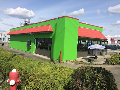
Going green, literally, in Downtown Langley

One of the great things about places like Downtown Langley is that they serve as an incubator of small business, and permit the reuse of older buildings.

For example, a derelict fast-food restaurant along Fraser Highway was recently transformed into a new family-run restaurant.

Former Arby's, now family-run restaurant along Fraser Highway

Another example is a strip mall that was recently renovated.

Recently renovated strip mall at 20226 Fraser Highway in Downtown Langley

While I am happy to see buildings being reused for new purposes, and new businesses growing in my community, I’m not the biggest fan of the vibrant green paint that was used in both of the renovations pictured.

When a renovation triggers a development application or building permit, a city can require certain standards be met. For example, the City of Langley's Official Community Plan and Downtown Master Plan contain language around using “high quality exterior finishes” to “present an attractive appearance.” Other cities are more prescriptive.

The City of Vernon, where I grew up, requires “when making an application for development in the City Centre, the proponent must illustrate how the proposal addresses the design guidelines through architecture relative to its location.”

The City of Vernon has very detailed design guidelines for its downtown. For example, when it comes to colour “the use of colour will be encouraged. Historic practice has been to encourage earth tones in the City Centre. Colour must be thoughtfully introduced over time and complement surrounding colour choices.”

The design of buildings is important in any community. When creating a sense of place, the design of buildings should complement a well-designed public realm.

While the City of Langley can update its design guidelines for Downtown Langley in the future, even today, the Official Community Plan and Downtown Master Plan provide the framework for Council to ensure that new development and redevelopment contribute to creating a cohesively designed core.

Wednesday, September 9, 2015

Designing for able-bodied people who drive has no place in Downtown Langley

I am not a fan of drive thrus or parking lots that front streets. Surface parking lots that surround buildings do many things such as spreading out buildings, and increasing the time it takes to walk from one place to another. They also create boring, hostile environments for walking. The end result being the degradation of the public realm, and the erosion of walkability. Walking and walkability includes getting around with personal mobility devices.

Besides encouraging idling and creating an ugly public realm, drive thrus send the signal that an area should be accessed by driving only.

Downtown Langley is a great places to live and visit because it is walkable, safe, and built at a human scale. One of the keys to the future success of Downtown Langley is the continued creation of a inviting, walkable public realm.

Having a new Tim Hortons at the corner of 203rd Street and Douglas Crescent is better than an empty lot. Many people have told me this. So what if it isn’t as walkable as it could be? So what if it includes a drive thru, highway-scale sign, and a parking that fronts Douglas Crescent?

While one parking lot and one drive thru won’t destroy the public realm and walkability of Downtown Langley, two, three, ten projects over the period of a decade will. This is why it is important that every development project in Downtown Langley be evaluated on how it will contribute to creating a walkable, vibrant public realm. By the way, there are simple ways to enhance walkability while still including surface parking.

On the topic of surface parking and that Tim Hortons, even its parking lot is not designed well. Normally, accessible parking is placed as close to a business as possible. At this Tim Hortons, the accessible parking is on the other side of the parking lot.

Accessibly parking is located across the parking lot from the store's entrance. Select the image to enlarge.

To make matters worse, the ramp that provides access to the Tim Hortons can become blocked.

Large vehicles can block the ramp between the parking lots and the entrance to the store. Select the image to enlarge.

The design of the Tim Hortons says that it is for able-bodied people who can drive. Downtown Langley is a place for people of all ages and all abilities; a place where you should feel safe walking, cycling, and scootering. This is why I take issue with the design of projects like this Tim Hortons.

Tuesday, September 8, 2015

Recent changes to allowed uses within the Agricultural Land Reserve

Last year, the provincial government changed the legislation that protects agricultural land in BC. One of the biggest changes was splitting the Agricultural Land Reserve (ALR) into two zones.

In Zone 1, which included the South Coast, Vancouver Island, and the Okanagan, the Agricultural Land Commission and its regional panels must preserve agricultural land and work with all levels of government to encourage farm uses on agricultural land.

With land in Zone 2, the rest of the province, in addition to preserving agricultural land for farm uses, the Commissions and its regional panels can also permit uses on agricultural land if there is economic, cultural and social value; it meet regional and community planning objective; or it meets other prescribed considerations.

The introduction of the Zone 2 additional uses created a paradox because those additional uses can only be considered if those uses still result in the preservation of agricultural land for farming. If land within the ALR is not suitable for farming, it really should be excluded from the ALR. Luckily in Metro Vancouver, we are in Zone 1.

When the province changed the legislation last year, they also started a review process to update what uses would be allowed within the ALR that didn’t require the approval of the Commission.

The province recently expanded non-agricultural uses permitted within the ALR, and was considering changing the rules around the subdivision of land within the ALR. The subdivision of farmland can result in fragmentation which reduces the ability of land to be efficiently farmed.

As of June 2015, the following changes were made to uses allowed within the ALR in Zone 1 according to a Metro Vancouver staff report:

  • Allow the production of marihuana in accordance with federal regulations
  • Allow biodiversity conservation, passive recreation, heritage, wildlife and scenery viewing purposes
  • Allow aggregate extraction if the total volume of materials removed is less than 500 cubic metres
  • Change where products sold at a farm shops can be sourced from
  • Change where farm products stored, packed, prepared, or processed can be sourced from
  • Allow breweries, distilleries, or meaderies within the ALR if 50% of the farm products used in the creation of beverages are grown on the farm
  • Allow the selling of alcoholic beverage, other than ones produced on the farm, in a lounge or for special events
  • Allow the leasing of sections of farmland as long as farming is the intended use
  • Allow, in addition to one secondary suite in a single family dwelling, either one manufactured home or single level addition to an existing dwelling

Many people were concerned that the province would further weaken the protection of farmland, but the changes in regulation so far have been reasonable.

More changes could still be in the works around “agri-tourism” which is circularly defined as tourist activity on farmland.

Thursday, September 3, 2015

That half-full bus is a better use of road space than two Honda Civics

One of the things that I hear sometimes is people complaining about buses being half-full, taking up much needed road space. This is a common perception, but does this perception line up with reality? At what point would a typical bus take up less space per passenger than a car?

To illustrate this, I picked a typical 40’/12.2m transit bus and a 179.4”/4.5m 2015 Honda Civic Sedan.

Travelling 50km/h, two Honda Civics fit into the space of one bus. Select image to enlarge.

When travelling 50km/h on the road, you should leave at least 2 seconds between vehicles. This happens to work out to about 30 meters. If a typical car has 1 to 2 passengers, a typical bus would need to have 2 to 4 passengers to take up the same amount of space as a car per passenger. More than 5 passengers, and a bus becomes a more efficient use of limited road space. A typical 40’ bus in Metro Vancouver fits about 70 people, so a half-full bus has about 35 people. That means that a half-full bus uses at least 8 times less road space per passenger than a typical car.

This even holds true when stopped in a queue at an intersection. Research shows that most people stop their cars about their vehicle length behind the vehicle in front of them.

Stopped at an intersection, two Honda Civics fit into the space of one bus. Select image to enlarge.

Now passenger vehicles come in all shapes and sizes, but the point is that it doesn’t take much for a bus to be a better way to move people around in an urban environment over longer distances. Even if cars ran only on solar power, in urban centres, we simplely could not afford to build large enough roads to have everyone drive a personal vehicle. Even if we could afford to build large enough roads, we would destroy our Metro Vancouver way-of-life in the process.

Wednesday, September 2, 2015

Where do younger households live? Where do people retire in Metro Vancouver?

Once a month, Metro Vancouver posts an aptly named Map of the Month. These maps look at the geography of Metro Vancouver with an eye on how it relates to the Regional Growth Strategy, and the creation of a livable region.

I thought I would share the map that will be posted for September.

Demographics and Development: Major Development Projects and Age Cohort Housing Trends. Select map to enlarge.

The graphs show what housing types various household groups live in based on average adult age, and whether they own or rent. Not surprising, but 30% of households aged 25-35 live in single family homes. That number rises to 55% for those aged 35-64 before dipping down to 51% for households aged 65+. It will be interesting to see how housing type preferences trend moving forward.

The map shows which parts of the region have higher than, or lower than average numbers of households, grouped into three age categories. It turns out that Langley City and Clayton in Surrey are popular places for younger households. Willoughby in the Township of Langley is also a emerging choice for younger households. These younger households live in places with good transit access, or places where transit access will be improved shortly (like the Evergreen Line.)

Middle-aged households live in areas that have poorer transit access. South Surrey stands out as an area where many middle-aged households are living. Interestingly, UBC is also a popular location.

A higher than average amount of 65+ households live in the more rural parts of our region, and in some of the older communities like Tsawwassen, White Rock, and Crescent Beach. The North Shore also appears to be a retirement haven.

Besides demographic information, the map shows small dots which represent apartment and townhouse projects that are worth $20 million or more, that have been built since 2011.

The maps and graphs are based on the 2011 National Household Survey and BC Stats Major Projects Inventory (March 2015).

Tuesday, September 1, 2015

Latimer Neighbourhood plan receives Metro Vancouver staff support

Back in May, I posted about the new Latimer Neighbourhood land use plan. In general, the plan increases the diversity of housing types available in Willoughby along the 200th Street corridor. It also introduces mixed-use areas at major intersections along 200th Street. If Latimer is built as planned, it will support the creation of a walkable, bikeable, and transit-ready community.

One of the cool things about the plan is that it removes the original suburban business park zoning for the northwest corner of 80th Avenue and 200th Street, replacing it with mixed-use zoning.

Proposed regional land use changes in the Latimer Neighbourhood. Select map to enlarge.

Under the Metro Vancouver Regional Growth Strategy (RGS), this area is currently zoned as “mixed-employment”. To allow the mixed-use area, the regional zoning must be changed to “general urban.” Section 6.2.7 of the RGS allows municipalities to change regional land use zones within the Urban Containment Boundary as long as the total adjustments doesn’t total more than 1 hectare.

This can only be done if a municipality has a regional context statement that permits this. This context statement must be approved by the Metro Vancouver board. Because of all the legal issues between Metro Vancouver and the Township of Langley, the Township of Langley is one of the only municipalities without a regional context statement for the RGS.

Township of Langley Council has therefor requested a Type 3 amendment to the RGS to permit the changes in Latimer. A Type 3 amendment to the RGS only requires 50%+1 weighted vote approval of the Metro Vancouver board.

The Township of Langley would also like to change the regional land-use to “mixed-employment” for the area just west of the currently zoned office park. This would create about 3 hectares of land that could be used for commercial or industrial use.

Both Metro Vancouver staff and the TransLink board support these changes as it will support the Regional Growth Strategy. According to a Metro Vancouver staff report:

The Township of Langley’s Willoughby area is one of the largest developing urban areas in the region, and the urban form of this area is crucial to achieving several Metro 2040 goals. Overall, the proposed amendments will serve to shape the form of this emerging urban area in a manner generally consistent with Metro 2040’s goals and strategies. Primarily, the amendments allocate planned land use and density to promote concentrated residential and commercial development at strategic locations along the 200th Street corridor, which will become the main north-south transit corridor connecting this subregion of Metro Vancouver.