The Metro Vancouver Regional District has 22 members, which includes Tsawwassen First Nation and 21 municipalities. One of the significant responsibilities of the Regional District is to create a regional growth strategy. The creation of a regional growth strategy is provincially mandated. All members of the Regional District, including Langley City, must follow the regional growth strategy.
Metro Vancouver has some unique challenges when it comes to land use. We are surrounded by mountains, the US border, and the ocean. We have the largest and busiest port in Canada, which means industrial land is at a premium. We have the most fertile farmland in BC, protected mainly by the Agricultural Land Reserve. We also have a growing economy and population, meaning we need to build more housing. People in our region also believe in protecting greenspace, which helps clean our air and water.
Because of this, it is no surprise that each successive regional growth strategy has become more prescriptive.
The happy path for adopting an updated regional growth strategy is for all Metro Vancouver Regional District members to willingly vote in favour of the new policy. Langley City Council voted to adopt the new regional growth strategy, Metro 2050, back in June. In fact, all members of the Regional District except for Surrey and the Township of Langley have adopted the new regional growth strategy.
In Surrey, Council wants to remove the Rural regional land-use designation, changing it to the General Urban regional land-use designation. Rural land in Metro Vancouver has very low-density residential, agricultural, smallscale commercial, smallscale industrial, or institutional uses that do not require the provision of urban services such as sewerage or transit. Surrey sees rural areas as a “land bank” for future development. The regional growth strategy explicitly states, “Rural lands are not intended as future urban development areas and generally will not have access to regional sewerage services.”

|
| Map of land with the regional Rural land-use designation in Metro 2050. Select map to enlarge. |
This Rural land-use designation existed in the previous Metro 2040 regional growth strategy, so Surrey Council must get Metro Vancouver Regional District Board approval to convert rural land to urban land even today.
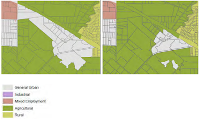
Township of Langley Council and the Regional District have a long-standing dispute focusing on an area around Trinity Western University called the “University District.” The Township of Langley and property owners in the area want to exclude 152 hectares of land from the regional Agricultural land-use designation even though the Agricultural Land Commission has only allowed for the exclusion of 23.4 acres from the Agricultural Land Reserve. While Township of Langley Council has other concerns that I believe the Regional District and its members will be able to address, the biggest challenge will be removing agricultural land for urban use. The challenge is that the majority regional viewpoint is that agricultural land, even if not actively farmed, provides ecological service to the region. In the Township, there is a significant view that land that isn’t Class 1 or 2 agricultural lands should be converted to industrial or urban uses.

|
| Township of Langley’s proposed land use, left. Metro 2050 land use, right. University District. Select map to enlarge. |
With the upcoming local government elections, adopting the new regional growth strategy will likely be paused into the new year.
If Surrey, the Township of Langley, and Regional District cannot find a happy path forward, it will become messy and legal.

No comments:
Post a Comment
All comments are moderated.