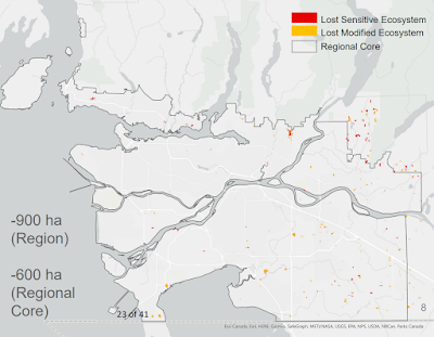
The Metro Vancouver Regional District keeps track of our region's sensitive and modified ecosystems. Sensitive ecosystems include mostly unmodified natural areas such as mountain fields, intertidal areas, mature forests, wetlands, and riparian areas along waterways. These are critical places that support biological diversity. Modified ecosystems can also support various animal and plant species, and areas include unused farm fields and young forests.
About every six years, Metro Vancouver updates their ecosystem mapping. As I posted about in the past, between 2009 and 2014, 426 hectares of sensitive ecosystem were lost in the Metro Vancouver core. Between 2014 and 2020, 207 hectares were lost in the core. This is a slowdown of ecosystem loss, though more can be done.

|
| Map of ecosystem loss in Metro Vancouver between 2014 and 2022. Select the map to enlarge—source: Metro Vancouver. |
The leading types of natural areas lost in the core area were mature forests, riparian areas, and wetlands.
The top causes of ecosystem loss are logging, increased agriculture activities, and urban growth.
The Metro Vancouver Regional Growth Strategy has specific measures to help reduce ecosystem loss, which is likely why the loss was less pronounced in this most recent period. As the next steps, Regional District staff are working on mapping what sensitive ecosystems are protected and which are not. They will also assess the quality of these ecosystem areas. This mapping and assessment will likely inform what land the Regional District could acquire for conservation purposes. They will also map the change in land becoming protected over the years.
Please read the "Sensitive Ecosystem Inventory 2020 Update" in the September 7th Regional Planning Agenda for more information.

No comments:
Post a Comment
All comments are moderated.