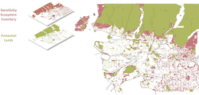
Metro Vancouver is a region in constant tension, and nowhere is this more evident than in how we use or preserve the land. Our region is home to more than half of the population of British Columbia. We are also home to the most productive farmland in the province. Metro Vancouver has some of the most sensitive habits from migratory birds, fish, and plant life in the country.
The Metro Vancouver Regional District controls a significant portion of land in our region. Of the land that the regional district controls, 5% is protected as parks and 17% is protected for our watershed. The following chart shows that around 40% of the land in our region is protected from development.
 |
| Percentage of protected areas in Metro Vancouver. Source: Metro Vancouver. |
The following map from Metro Vancouver shows what land is considered sensitive ecosystems which is not protected (red) and what areas are currently protected (green). The unprotected areas represent about 10% of the land in our region.
 |
| Map of sensitive ecosystems in Metro Vancouver. Source: Metro Vancouver. |
One of the regional district’s goals is to acquire property for conservation purposes. The following map shows areas that provide the highest conservation potential in our region (yellow).
 |
| Map of areas with high regional conservation potential. Select map to enlarge. Source: Metro Vancouver. |
There is significant opportunity in the South of Fraser to protect more land, thought the regional districts ability to purchase this land is limited due to the cost of land. As time goes on, the ability to purchase these properties diminishes. Metro Vancouver has shown leadership in the past such as with the protection of Burns Bog. I’m hopefully that this legacy of purchasing and protecting land continues.

No comments:
Post a Comment
All comments are moderated.